


Gokyo Lakes Trek: Complete 2026 Itinerary, Cost & Planning Guide
The Gokyo Lakes Trek is a 12-14 day Everest-region trek to six sacred turquoise lakes and the 5,357m Gokyo Ri viewpoint, where you see four 8,000m peaks—Everest, Lhotse, Makalu, and Cho Oyu—in one panorama. It costs roughly $905-$2,350 and sees 70-80% fewer trekkers than Everest Base Camp.
| Route | Duration | Max Altitude | Difficulty | Permits | Teahouses | Crowds |
|---|---|---|---|---|---|---|
| Gokyo Lakes Trek | 12-14 days | 5,357m | Moderate-Difficult | $38-45 | Good | Low-Moderate |
| Everest Base Camp | 12-16 days | 5,545m | Moderate-Challenging | $38-45 | Excellent | High (Peak Season) |
| Three Passes Trek | 18-21 days | 5,535m | Strenuous | $38-45 | Basic-Good | Low |
| EBC via Gokyo (Cho La) | 16-18 days | 5,545m | Strenuous | $38-45 | Good | Moderate |
The Gokyo Lakes Trek stands as one of the Himalaya's best-kept secrets—a journey to six sacred turquoise lakes nestled in the shadow of four 8,000-meter giants. While over 50,000 trekkers annually crowd the Everest Base Camp trail, the parallel Gokyo Valley receives a fraction of that traffic, offering the same breathtaking Khumbu scenery with significantly more solitude.
This isn't merely an "alternative to EBC"—it's a distinct experience that many seasoned trekkers consider superior. The Gokyo Valley delivers what the Base Camp trail cannot: pristine glacial lakes that shift from emerald to sapphire depending on the light, sunrise views from Gokyo Ri that rival or exceed Kala Patthar, and the opportunity to walk alongside the Ngozumpa Glacier—the longest glacier in the entire Himalayan range.
For photographers, spiritual seekers, and trekkers who value natural beauty over bucket-list checkmarks, the Gokyo Lakes Trek represents the quintessential Everest region experience.
Route Overview: Why Gokyo Captures Hearts
12-14 days (Lukla to Lukla)
5,357m (Gokyo Ri Summit)
4,790m (Gokyo Village)
100-110 km round trip
Moderate to Difficult
Oct-Nov (Autumn), Mar-May (Spring)
Lukla (2,860m)
Sagarmatha National Park, Khumbu
SNP Entry + Khumbu Municipal
Teahouse lodges throughout
Not mandatory (recommended)
6 glacial lakes (Gokyo Cho)
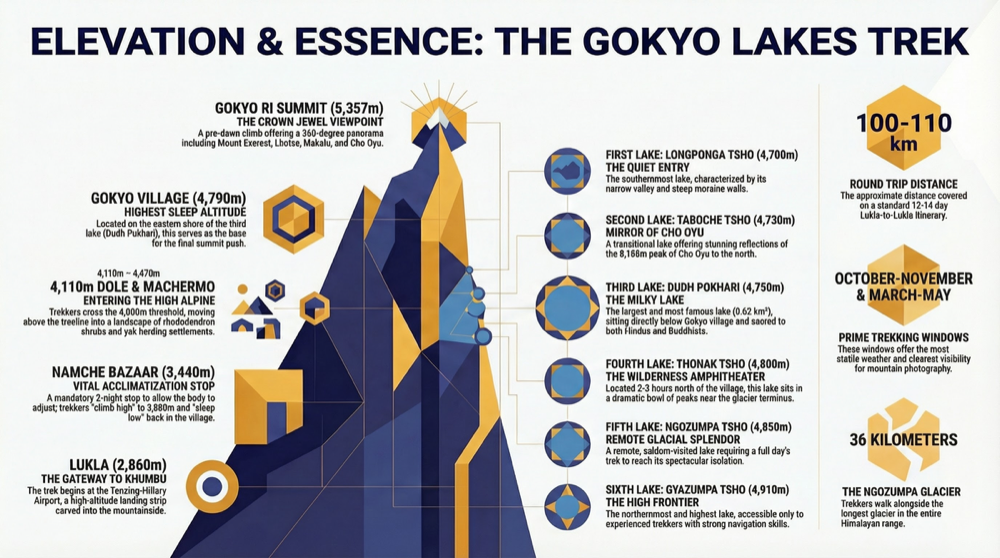
The Gokyo Valley splits from the classic EBC route at Namche Bazaar, climbing northwest through increasingly dramatic terrain to reach a chain of six glacial lakes revered by both Hindus and Buddhists. The third lake, Dudh Pokhari, sits at the foot of Gokyo village and serves as the trek's spiritual and logistical center.
What makes this route exceptional:
- The Six Sacred Lakes — The world's highest freshwater lake system, each pool displaying otherworldly turquoise coloration from glacial minerals
- Gokyo Ri (5,357m) — A viewpoint offering panoramic views of four 8,000-meter peaks: Everest, Lhotse, Makalu, and Cho Oyu
- Ngozumpa Glacier — At 36 kilometers, the longest glacier in the Himalayas, a stark landscape of ice and moraine
- Sherpa Culture — Authentic villages from Namche to Gokyo preserving centuries of Buddhist tradition
- Significantly Fewer Crowds — 70-80% less traffic than the EBC trail during peak season
The Six Sacred Lakes of Gokyo: A Complete Guide
The Gokyo lake system consists of six primary glacial lakes, collectively known as Gokyo Cho in the local Sherpa dialect. Fed by meltwater from the Ngozumpa Glacier, these lakes hold deep spiritual significance and display extraordinary natural beauty.
Understanding the Sacred Significance
Both Hindu pilgrims and Buddhist devotees consider these lakes sacred. According to local tradition, Lord Shiva resides in the waters, and ritual bathing during the Janai Purnima festival (full moon of August) is believed to wash away sins and grant spiritual merit. Sherpa Buddhists associate the lakes with the protective deity Jomo Miyo Langsangma, one of the five long-life sisters of Tibetan Buddhism.
Lake Preservation
These glacial ecosystems are extraordinarily fragile. Never wash clothes, dishes, or yourself directly in the lakes. Use biodegradable soap only, and dispose of all waste properly. The turquoise color comes from suspended glacial sediment—any pollution is highly visible and long-lasting.
The Six Lakes: North to South
First Lake (Longponga Tsho) — 4,700m The southernmost and first lake encountered when approaching from Machermo. Smaller than the others, it sits in a narrow valley with steep moraine walls. Most trekkers pass quickly on the way to Gokyo, but the early morning reflections here are stunning when the water is still.
- Size: Approximately 0.12 km²
- Access: 2-3 hours from Machermo
- Notable Features: Quietest of all six lakes, excellent for photography at dawn
Second Lake (Taboche Tsho) — 4,730m A transitional lake between the first and third, slightly larger and deeper. The trail passes along its eastern shore, offering continuous views of Cho Oyu (8,188m) to the north. Named after the nearby Taboche Peak (6,495m).
- Size: Approximately 0.18 km²
- Access: 30-45 minutes from First Lake
- Notable Features: Clear views of Cho Oyu, relatively shallow, often partially frozen in spring
Third Lake (Dudh Pokhari) — 4,750m The largest and most famous of the Gokyo lakes. Dudh Pokhari ("Milk Lake" in Nepali) sits immediately below Gokyo village and the Gokyo Ri viewpoint. This is where most trekkers spend 1-2 nights, using the village as a base for exploration.
- Size: Approximately 0.62 km² — the largest of the six
- Depth: Up to 43 meters
- Access: Adjacent to Gokyo village
- Notable Features: Best teahouse infrastructure, starting point for Gokyo Ri ascent, most accessible for extended visits
- Sacred Bathing: Pilgrims bathe here during Janai Purnima festival
Fourth Lake (Thonak Tsho) — 4,800m Requires a day hike north from Gokyo village (2-3 hours one way). Significantly less visited than the third lake, offering a more wilderness experience. The lake sits in an amphitheater of peaks with the Ngozumpa Glacier's terminus visible to the west.
- Size: Approximately 0.50 km²
- Access: 2-3 hours from Gokyo village, day hike
- Notable Features: Fewer visitors, dramatic glacial backdrop, excellent acclimatization hike
Fifth Lake (Ngozumpa Tsho) — 4,850m The most remote of the regularly visited lakes. Getting here requires a full day expedition from Gokyo, passing the fourth lake and navigating increasingly rough terrain. The effort rewards with true solitude and some of the most dramatic scenery in the valley.
- Size: Approximately 0.35 km²
- Access: 4-5 hours from Gokyo village, full day hike
- Notable Features: Most remote, rarely visited, spectacular isolation
Sixth Lake (Gyazumpa Tsho) — 4,910m The northernmost and highest lake, rarely visited by trekkers. Reaching it requires navigation skills and a full day's commitment. The terrain is rough, with moraine crossings and no established trail for portions of the route. Only attempt with a guide or strong navigation experience.
- Size: Approximately 0.20 km²
- Access: 5-6+ hours from Gokyo village, expedition-style day hike
- Notable Features: True wilderness, seldom visited, for experienced trekkers only
Pro Tip
Most trekkers only visit the third lake (Dudh Pokhari) adjacent to Gokyo village. Plan an extra acclimatization day to hike to the fourth and fifth lakes—this day trip offers superior scenery and helps prevent altitude sickness before your Gokyo Ri summit attempt.
Gokyo Ri Summit: The Crown Jewel Viewpoint
The pre-dawn climb to Gokyo Ri (5,357m) represents the emotional and visual climax of the Gokyo Lakes Trek. Standing atop this rocky prominence, trekkers witness a 360-degree panorama that many consider the finest accessible viewpoint in the entire Himalayan range. For a deep dive on the summit push itself, see our dedicated Gokyo Ri summit guide.
What You'll See from the Summit
Four 8,000-Meter Peaks in One View:
| Peak | Elevation | Direction from Gokyo Ri | Notable Features |
|---|---|---|---|
| Mount Everest | 8,848.86m | Southeast | The iconic pyramid, clearly visible without obstruction |
| Lhotse | 8,516m | Southeast | Fourth highest peak, connected to Everest by the South Col |
| Makalu | 8,485m | East-Southeast | Fifth highest, distinctive triangular summit |
| Cho Oyu | 8,188m | North-Northwest | Sixth highest, dominates the northern skyline |
Additional Panoramic Highlights:
- The entire Gokyo lake system spread below, their turquoise waters catching the first light
- Ngozumpa Glacier stretching 36 kilometers southward, the largest glacier in Nepal
- Gyachung Kang (7,952m)—the highest peak under 8,000 meters
- Countless 6,000-7,000m peaks including Cholatse, Taboche, and Kangtega
- On clear days, visibility extends to peaks in Tibet
Gokyo Ri vs. Kala Patthar: An Honest Comparison
The debate between Gokyo Ri and Kala Patthar (the EBC trek's famous viewpoint) is one of the Khumbu's great discussions. Here's an objective assessment:
| Factor | Gokyo Ri (5,357m) | Kala Patthar (5,545m) |
|---|---|---|
| Altitude | 287m lower—easier breathing | Higher—more challenging |
| Everest View | Excellent—unobstructed pyramid | Excellent—slightly closer |
| Other Peaks | 4+ eight-thousanders visible | 3 eight-thousanders visible |
| Lake Views | Stunning—all six lakes visible | No lakes visible |
| Glacier View | Ngozumpa Glacier panorama | Khumbu Glacier below |
| Crowds | Significantly fewer trekkers | Often crowded at sunrise |
| Climb Duration | 2-3 hours from Gokyo | 2-3 hours from Gorak Shep |
| Trail Condition | Rocky but well-defined | Rocky, steeper sections |
| Sunrise Quality | Excellent lighting on all peaks | Excellent on Everest/Lhotse |
The Verdict: Gokyo Ri offers comparable Everest views plus the unique addition of the lake system and longer glacier panorama. Kala Patthar provides slightly closer Everest views at greater altitude. Serious trekkers should consider combining both via the Cho La Pass crossing.
Summit Day: Practical Guide
Recommended Schedule:
- 4:30-5:00 AM: Depart Gokyo village (headlamps required)
- 6:30-7:00 AM: Arrive summit before or at sunrise
- 7:00-8:00 AM: Photography and observation (sunrise peaks around 6:15-6:45 AM depending on season)
- 8:30-9:30 AM: Return to Gokyo village for breakfast
Essential Gear for Summit:
- Headlamp with fresh batteries (critical for pre-dawn start)
- Down jacket and multiple warm layers
- Warm hat and gloves (summit temperatures: -10°C to -20°C at dawn)
- Camera with fully charged battery (keep spare battery warm in pocket)
- Snacks and water (at least 1 liter)
- Trekking poles (highly recommended for stability)
- Sunglasses and sunscreen (essential once sun rises)
Altitude Warning
At 5,357m, oxygen levels are approximately 50% of sea level. If you experience severe headache, nausea, confusion, or difficulty breathing during the climb, descend immediately. Gokyo Ri will still be there—your health comes first. Never push through moderate-to-severe altitude sickness symptoms.
Ngozumpa Glacier: Walking Alongside a River of Ice
The Ngozumpa Glacier dominates the Gokyo Valley's western edge—a 36-kilometer river of ice, debris, and moraine that stands as the longest glacier in the entire Himalayan range. Unlike the heavily crevassed Khumbu Icefall visible from EBC, the Ngozumpa presents a more accessible (though no less impressive) glacial landscape.
Glacier Facts and Science
- Length: 36 kilometers (longest in the Himalayas)
- Width: Up to 2 kilometers at its widest point
- Source: Ice fields below Cho Oyu, Gyachung Kang, and surrounding peaks
- Terminus: Feeds meltwater into the Dudh Koshi river system
- Type: Debris-covered glacier—the ice is insulated by rock rubble, slowing melt
- Rate of Retreat: Approximately 30-40 meters per year (accelerating due to climate change)
Walking on the Glacier
Several points along the trek allow safe walking on the glacier's surface. The trail between Gokyo and Thagnak (used for Cho La crossing) traverses portions of the glacier, offering close encounters with:
- Glacial pools: Turquoise meltwater ponds forming in depressions
- Ice pinnacles: Seracs and ice towers exposed where debris cover is thin
- Moraine ridges: Rocky debris pushed to the glacier's edges over centuries
- Glacial streams: Meltwater channels cutting through ice and rock
Climate Witness
The Ngozumpa Glacier is a visible indicator of climate change in the Himalayas. Comparison photos from the 1950s and today show dramatic recession. Trekking here offers a sobering, firsthand witness to environmental change. Please consider your environmental impact and support climate-conscious trekking practices.
Glacial Lake Outburst Flood (GLOF) Awareness
Climate change has created growing glacial lakes behind moraine dams throughout the Himalayas. While the main Gokyo lakes are natural and stable, scientists monitor several smaller glacial lakes for potential outburst flood risk. This is an observed phenomenon, not an immediate trekker danger, but understanding the context adds depth to your glacial experience.
Complete 12-14 Day Itinerary: Day-by-Day Breakdown
This itinerary follows the standard Gokyo Lakes route with proper acclimatization days. Rushing this schedule significantly increases altitude sickness risk.
Day 1: Fly to Lukla (2,860m), Trek to Phakding (2,610m)
Trek Details: 3-4 hours, 8 km, -250m descent
The adventure begins with the legendary flight to Lukla's Tenzing-Hillary Airport—a short runway carved into a mountainside that immediately signals you've entered a different world. After the adrenaline of landing, the first day's trek is intentionally gentle, following the Dudh Koshi River downstream through pine forests and Sherpa villages.
Route Highlights:
- First suspension bridges over rushing glacial rivers
- Sherpa villages with traditional stone architecture
- Entry point to Sagarmatha National Park buffer zone
- Mani walls and prayer wheels along the trail
Information current as of January 2025.
Lukla
2,860m
Room: $8-15
Dal Bhat: $6-9
Last ATM until Namche. Stock up on snacks and cash. Gear rental available but quality varies.
Phakding
2,610m
Room: $5-10
Dal Bhat: $5-7
Pleasant riverside village. Good acclimatization start—actually lower than Lukla.
Day 2: Phakding to Namche Bazaar (3,440m)
Trek Details: 5-6 hours, 11 km, +830m ascent
The most demanding day of the first section. After a pleasant morning along the river, the trail steepens dramatically after the Sagarmatha National Park entrance at Monjo. The final 2-hour climb to Namche gains 600 meters and provides your first real test at altitude.
Route Highlights:
- Multiple suspension bridges including the famous Hillary Bridge
- Sagarmatha National Park entrance checkpoint (permits checked)
- First views of Everest and Lhotse on clear days (from the final climb)
- Entry into the heart of Sherpa country
Permit Checkpoints:
- Monjo: National Park permit and Khumbu Municipality permit checked
- Jorsale: Secondary checkpoint
Pro Tip
Start early from Phakding to reach the final Namche climb before clouds typically develop (around noon). The first Everest view occurs on a bend in the trail during the steep ascent—watch for trekkers stopped and pointing upward.
Day 3: Namche Bazaar Acclimatization Day
Trek Details: 3-5 hours optional day hike, return to Namche
Critical acclimatization day—never skip this. Namche Bazaar (3,440m) is the Khumbu's largest settlement and the perfect place to let your body adjust. Following the "climb high, sleep low" principle, you'll hike to higher elevation during the day but return to sleep at Namche.
Recommended Acclimatization Hikes:
| Destination | Altitude | Round Trip Time | Highlights |
|---|---|---|---|
| Everest View Hotel | 3,880m | 2-3 hours | Iconic panorama of Everest, Lhotse, Ama Dablam |
| Khumjung Village | 3,790m | 3-4 hours | Hillary School, monastery with "yeti scalp" |
| Syangboche Airport | 3,720m | 1-2 hours | Easy option, good views |
| Thame Valley (partial) | 3,500m | 4-5 hours | Quieter route toward Renjo La |
In Namche:
- Explore the Saturday market (if timing aligns)
- Visit the Sherpa Culture Museum
- Resupply snacks and batteries
- Enjoy bakery treats and coffee
- Attend the evening talk at the HRA (Himalayan Rescue Association) if available
Information current as of January 2025.
Namche Bazaar
3,440m
Room: $10-30
Dal Bhat: $7-10
Khumbu's main hub. Excellent acclimatization base. Saturday market famous. Irish Pub has cold beer. Last significant town before high camps.
Day 4: Namche Bazaar to Dole (4,110m)
Trek Details: 5-6 hours, 11 km, +670m net gain (with intervening descent)
This day marks the split from the EBC trail. Instead of continuing toward Tengboche, you'll climb northwest toward the Gokyo Valley. The trail ascends steeply from Namche, passes through Kyangjuma, and reaches the Mong La pass (3,975m) before descending slightly and climbing again to Dole.
Route Highlights:
- Split from EBC trail above Namche
- Mong La pass crossing with excellent views
- Entry into the quieter Gokyo Valley
- Rhododendron forests (blooming in spring)
- First significant altitude gain into the 4,000m zone
Trail Notes: The Mong La section can be exposed on windy days. Carry wind layers accessible. Views of Thamserku, Kangtega, and Cho Oyu open up as you enter the Gokyo drainage.
Information current as of January 2025.
Dole
4,110m
Room: $8-15
Dal Bhat: $7-9
Small yak-herding settlement. Limited choices but friendly lodges. Good views of surrounding peaks. First night above 4,000m—take it easy.
Day 5: Dole to Machermo (4,470m)
Trek Details: 3-4 hours, 6 km, +360m ascent
A shorter day designed to maintain safe altitude gain. The trail continues up the Gokyo Valley, passing through increasingly stark, high-altitude terrain. Machermo sits below dramatic peaks and serves as the final village before Gokyo.
Route Highlights:
- Dramatic high-altitude landscape above treeline
- Views of Cho Oyu emerging to the north
- Potential wildlife sightings (Himalayan tahr, musk deer, monal pheasant)
- Machermo HRA medical post (evening altitude talks during season)
Altitude Note: At 4,470m, you're now solidly in the zone where altitude sickness becomes a real concern. Pay attention to symptoms: headache, nausea, difficulty sleeping, loss of appetite. If symptoms are moderate, consider an extra acclimatization day here.
Information current as of January 2025.
Machermo
4,470m
Room: $10-18
Dal Bhat: $8-11
Final village before Gokyo. HRA post offers free daily altitude sickness talks (3pm). Limited dining options—dal bhat is your friend.
HRA Altitude Talk
The Himalayan Rescue Association runs an aid post in Machermo during trekking season. Attend the free afternoon talk on altitude sickness recognition and prevention—the information could save your life or a fellow trekker's life.
Day 6: Machermo to Gokyo (4,790m)
Trek Details: 4-5 hours, 9 km, +320m ascent
The approach to Gokyo is the scenic culmination of days of anticipation. After crossing a lateral moraine from the Ngozumpa Glacier, the first lake appears—a surreal patch of turquoise in the grey and white landscape. The trail passes all three lower lakes before arriving at Gokyo village, nestled on the shore of the third lake (Dudh Pokhari).
Route Highlights:
- First Lake (Longponga Tsho) appears below the trail
- Second Lake (Taboche Tsho) with Cho Oyu views
- Third Lake (Dudh Pokhari)—the largest and most famous
- Arrival at Gokyo village
- Views of Gokyo Ri rising above the village
The Moment: The first sight of the turquoise lakes against the grey moraine and white peaks is often the emotional high point of the trek. Give yourself time to absorb the view rather than rushing to Gokyo.
Information current as of January 2025.
Gokyo
4,790m
Room: $15-25
Dal Bhat: $10-14
Base for Gokyo Ri climb and lake exploration. Book ahead in peak season. Coldest nights of the trek—good sleeping bag essential. Don't overexert on arrival day.
Day 7: Gokyo Ri Summit (5,357m) & Fourth/Fifth Lake Exploration
Trek Details: 5-8 hours total, multiple objectives possible
The big day. Most trekkers prioritize the pre-dawn Gokyo Ri climb for sunrise, returning to the lodge for breakfast, then using the afternoon for a hike toward the fourth and fifth lakes. Alternatively, if weather is uncertain, you might explore the lakes first and save Gokyo Ri for the following morning.
Option A: Dawn Gokyo Ri Summit
- 4:30 AM departure from Gokyo
- 2-3 hour climb (600m elevation gain)
- Sunrise on summit (approximately 6:15-6:45 AM depending on season)
- Return to Gokyo by 9:00-10:00 AM
- Afternoon rest or light exploration
Option B: Fourth/Fifth Lake Hike (afternoon or full day)
- 2-3 hours to Fourth Lake (Thonak Tsho)
- 4-5 hours to Fifth Lake (Ngozumpa Tsho)
- Excellent acclimatization hike
- Far fewer people than third lake area
Combined Day Schedule (for strong, well-acclimatized trekkers):
- 4:30 AM: Depart for Gokyo Ri
- 7:00 AM: Summit for sunrise, photography
- 9:30 AM: Return to Gokyo, breakfast
- 11:00 AM: Depart for Fourth Lake
- 1:30 PM: Reach Fourth Lake, explore
- 4:00 PM: Return to Gokyo
Don't Rush
Many trekkers arrive at Gokyo and immediately attempt Gokyo Ri the next morning, still not fully acclimatized. If you have symptoms of altitude sickness (headache, nausea, extreme fatigue), rest an additional day. A second night at Gokyo significantly improves your summit experience and safety.
Days 8-10: Return Journey
Day 8: Gokyo to Dole
- 5-6 hours, mostly downhill
- Retrace the route, enjoying different perspectives
- Easier breathing at lower altitude
Day 9: Dole to Namche Bazaar
- 5-6 hours
- Significant descent
- Return to Namche's amenities and oxygen
Day 10: Namche to Lukla
- 6-7 hours
- Final trekking day
- Celebration dinner in Lukla
- Early sleep before flight day
Day 11-12: Lukla to Kathmandu (Buffer Days)
Always build 1-2 buffer days for Lukla flight delays. Weather cancellations are common, especially in peak season. Never book international flights for the day after your scheduled Lukla return.
If delayed in Lukla:
- Explore the village and surrounding trails
- Enjoy the slower pace before returning to Kathmandu
- Consider helicopter option if multi-day delay and schedule is tight ($500-700 shared)
Difficulty Assessment: What to Expect
Overall Difficulty Rating: Moderate to Difficult
The Gokyo Lakes Trek demands respect but remains achievable for reasonably fit trekkers without technical mountaineering experience. The difficulty comes from altitude, not terrain.
Terrain Difficulty: Moderate
- Well-maintained stone and dirt trails
- No technical climbing or rope work
- Some rocky sections, especially near Gokyo Ri summit
- Suspension bridges (some quite high and swaying)
- No glacier travel required on standard route
Altitude Difficulty: Significant
- Multiple days above 4,000m
- Highest sleep altitude: 4,790m (Gokyo)
- Summit altitude: 5,357m (Gokyo Ri)
- Oxygen at Gokyo is approximately 55% of sea level
- Proper acclimatization absolutely essential
Duration/Endurance Difficulty: Moderate-High
- 10-12 days of consecutive trekking
- Daily walking: 4-7 hours
- Cumulative fatigue builds over time
- Cold temperatures affect energy and sleep quality
Physical Fitness Requirements
Minimum Baseline:
- Walk 5-7 hours on uneven terrain without exhaustion
- Climb 500-800m elevation in a single day
- Carry 5-8 kg daypack for extended periods
- Handle consecutive days of physical exertion
- Function comfortably in cold conditions (-10°C to -20°C at night)
Recommended Training (8-12 weeks before trek):
| Weeks Out | Cardio | Strength | Hiking |
|---|---|---|---|
| 12-8 | 30 min, 3x/week (walk/jog/cycle) | Squats, lunges, core 2x/week | Weekend day hike (3-4 hrs) |
| 8-4 | 45 min, 4x/week | Add step-ups, stairs | Weekend hike with pack (4-6 hrs) |
| 4-0 | 60 min, 4x/week | Maintain | Back-to-back day hikes, overnight if possible |
Altitude Sickness Risk Assessment
| Altitude Zone | Location | Risk Level | Prevention |
|---|---|---|---|
| 2,500-3,500m | Lukla to Namche | Low-Moderate | Normal pace, hydrate well |
| 3,500-4,500m | Namche to Machermo | Moderate | Acclimatization day mandatory, slow pace |
| 4,500-5,000m | Gokyo area | High | Extra acclimatization day recommended |
| Above 5,000m | Gokyo Ri summit | Very High | Summit day only, descend same day |
For comprehensive altitude sickness information, see our Altitude Sickness Prevention Guide.
Best Time to Visit: Month-by-Month Analysis
| Month | High | Low | Conditions | Crowds | Notes |
|---|---|---|---|---|---|
| January | -5°C | -22°C | 15mm | Very Low | Extreme cold, some teahouses closed, potentially dangerous conditions |
| February | -2°C | -18°C | 20mm | Very Low | Still very cold, limited services, budget option for hardy trekkers |
| MarchBest | 4°C | -12°C | 35mm | Moderate | Warming trend, occasional snow, good value, fewer crowds |
| AprilBest | 7°C | -7°C | 50mm | Moderate-High | Spring warmth, rhododendrons blooming, good conditions |
| MayBest | 10°C | -4°C | 80mm | Moderate | Warmest pre-monsoon, afternoon clouds common, last spring window |
| June | 10°C | -2°C | 180mm | Very Low | Monsoon begins, rain and cloud, not recommended |
| July | 9°C | 0°C | 320mm | Very Low | Peak monsoon, heavy rain, poor visibility, trail conditions poor |
| August | 9°C | 0°C | 280mm | Very Low | Monsoon continues, not recommended for trekking |
| SeptemberBest | 6°C | -5°C | 140mm | Moderate | Monsoon ending, improving conditions, fresh snow on peaks |
| OctoberBest | 5°C | -10°C | 25mm | High | Peak season—best weather, clearest views, book ahead |
| NovemberBest | 2°C | -15°C | 10mm | Moderate-High | Excellent weather, colder than October, slightly fewer crowds |
| December | -2°C | -18°C | 10mm | Low | Cold but often clear, budget option, some services limited |
Prime Season Windows
Peak Autumn (October-November): The gold standard for Gokyo trekking. Crystal-clear skies, stable weather, and the best visibility for mountain views. October is busiest; November offers similar conditions with slightly fewer trekkers and colder temperatures. For a month-by-month deep dive, see our best time to trek Gokyo Lakes guide.
Spring (March-May): Warmer than autumn with blooming rhododendrons at lower elevations. April and May offer good conditions, though afternoon clouds are more common. Late May approaches monsoon—watch weather forecasts carefully.
Shoulder Season Considerations
September: Monsoon is ending but unpredictable. Late September can offer excellent conditions with fewer crowds than October. Trails may be muddier.
December: Cold but often clear. A budget option for well-equipped trekkers. Some teahouses at higher elevations may close or offer limited services.
Gokyo vs. EBC: Crowd Comparison
The Gokyo Valley sees approximately 70-80% fewer trekkers than the classic EBC route even during peak season. This means:
- Easier teahouse availability (though still book ahead in October)
- Quieter trails for contemplation and photography
- More intimate interactions with local Sherpa communities
- Less pressure and noise at viewpoints
Cost Breakdown: Budget to Premium
Understanding true costs prevents budget surprises. Gokyo is slightly less expensive than EBC due to shorter overall distance and fewer "famous" stops with inflated prices.
Budget Independent Trek ($1,200-$1,800)
| Category | Cost (USD) | Notes |
|---|---|---|
| Lukla flights (round-trip) | $215-400 | Book early; peak season prices higher |
| Permits (SNP + Municipal) | $40 | Fixed government fees |
| Accommodation (10 nights @ $8-15) | $80-150 | Basic rooms, shared bathrooms |
| Food (10 days @ $20-30) | $200-300 | Dal bhat maximizes value |
| Hot showers, charging | $40-80 | Higher elevations charge more |
| Travel insurance | $100-150 | Must cover 6,000m altitude, helicopter evacuation |
| Kathmandu (3 nights) | $45-90 | Budget guesthouses |
| Contingency | $50-100 | Flight delays, emergencies |
| TOTAL | $905-$1,310 | Add guide/porter if desired |
Standard Guided Trek ($1,800-$2,500)
| Category | Cost (USD) | Notes |
|---|---|---|
| Agency package (guide, porter, permits, accommodation, meals) | $1,200-$1,700 | Varies by agency |
| Lukla flights | Often included | If not, add $215-400 |
| Personal expenses | $100-200 | Drinks, showers, snacks, souvenirs |
| Travel insurance | $100-150 | |
| Kathmandu hotel | $75-150 | 2-3 star typical |
| Tips (guide + porter) | $80-150 | Standard: guide $5-8/day, porter $3-5/day |
| TOTAL | $1,555-$2,350 |
Premium Trek ($2,500-$3,500)
| Category | Cost (USD) | Notes |
|---|---|---|
| Premium agency package | $1,800-$2,500 | Private guide, upgraded lodges |
| Helicopter one-way option | $500-700 | Time-saving, spectacular |
| Premium travel insurance | $150-250 | Comprehensive coverage |
| Kathmandu 4-star hotel | $150-300 | Dwarika's, Hyatt, etc. |
| Tips and gratuities | $150-300 | Higher for premium service |
| TOTAL | $2,750-$4,050 |
Hidden Costs to Budget For
- Hot showers: NPR 400-700 ($3-5) at higher elevations
- Charging electronics: NPR 400-600 per device at Gokyo
- WiFi: NPR 400-600 per hour (slow at best)
- Bottled water: NPR 250-500 per liter—bring purification instead
- Flight delays: Extra hotel and food costs
- Bar drinks: Beer $6-10 at higher camps
Accommodation and Food on the Gokyo Lakes Trek
The Gokyo Lakes trek is a classic teahouse trek—you sleep in family-run lodges and eat at each village rather than camping. Accommodation and food are simple but reliable all the way to Gokyo (4,790m).
Teahouse Accommodation
- Rooms: Twin-bed wooden rooms with thin mattresses, blankets, and shared squat or basic Western toilets. Rooms are unheated; only the dining room has a stove (often yak-dung fuelled above the treeline).
- Cost: $5-10/night at Phakding, $10-30 at Namche, and $15-25 at Gokyo. Lodges keep rates low expecting you to eat dinner and breakfast where you sleep.
- Booking: In October you should have a guide or agency call ahead to Gokyo—the village has limited beds and fills fast. Outside peak season, walking in is fine. For tactics, see our guide to booking teahouses in advance and the tea house trekking explained overview.
- Warmth: Bring a sleeping bag rated to -15°C (ideally -20°C) for Gokyo's cold nights. Check our sleeping bag temperature guide before you go.
Food and Drinking Water
Menus are standardized across the Khumbu and get pricier with altitude. Dal bhat (lentils, rice, vegetables, free refills) is the best-value, most energy-dense meal and is what guides and porters eat—see our dal bhat trekking guide.
- Meal prices: $5-7 at Phakding rising to $10-14 per dish at Gokyo. Budget $20-30/day for food.
- Typical dishes: Dal bhat, fried rice and noodles, Sherpa stew, momos, potato dishes, pancakes, porridge, and Tibetan bread.
- Drinks: Black tea is cheap; bottled water costs NPR 250-500/litre at Gokyo. Carry purification and refill instead—see our water purification guide.
- At altitude: Eat more carbohydrates, avoid alcohol above 4,000m, and keep eating even when appetite drops—calories aid acclimatization.
Pro Tip
Order the same dinner the whole table is having and you'll be served faster, hotter, and with less fuel waste. Above Machermo, anything that isn't dal bhat or noodles can take an hour to arrive and uses scarce kerosene.
Guide or Self-Guided? Doing the Gokyo Lakes Trek
One of the most common questions—including from Reddit hikers researching this route—is whether to hire a guide or trek the Gokyo Lakes independently. Both are legal in the Khumbu, unlike Manaslu or Upper Mustang.
You can trek Gokyo self-guided if you:
- Have prior high-altitude experience and recognize altitude sickness symptoms
- Are comfortable navigating a well-marked but occasionally faint trail (especially toward the 4th-6th lakes)
- Carry your own pack or hire a porter only
- Want the lowest cost ($905-$1,310 budget range)
Hire a guide (or guide + porter) if you:
- Are on your first Nepal trek or first time above 4,000m
- Want someone to manage teahouse bookings, monitor your health, and handle an evacuation decision
- Value Sherpa cultural interpretation along the way
- Are a solo traveler wanting a safety backup
A licensed guide costs roughly $25-35/day and a porter $18-25/day, both before tips (guide $5-8/day, porter $3-5/day). Hiring through a verified local agency bundles the guide, permits, and logistics into one package and ensures fair porter treatment—see our porter ethics guide. For a deeper breakdown of every line item, read the Gokyo Lakes cost breakdown.
Solo trekker tip
Even confident independent trekkers benefit from at least a porter on Gokyo—the cold, the altitude, and the long fourth/fifth-lake day hikes are far safer with a second person. New Nepal regulations increasingly favour guided trekking in national parks, so confirm current rules with your operator for 2026.
Gokyo Lakes vs. Everest Base Camp: The Complete Comparison
This is the question most trekkers face: Gokyo or EBC? Here's an honest, detailed comparison to help you decide—and our standalone Gokyo Lakes vs. EBC comparison goes even deeper.
| Factor | Gokyo Lakes Trek | Everest Base Camp Trek |
|---|---|---|
| Primary Goal | Sacred lakes, panoramic views | Reach foot of Everest, see Khumbu Icefall |
| Duration | 10-14 days | 12-16 days |
| Maximum Altitude | 5,357m (Gokyo Ri) | 5,545m (Kala Patthar) |
| Sleep Altitude | 4,790m (Gokyo) | 5,164m (Gorak Shep) |
| Crowd Level | Low-Moderate | High-Very High |
| Trail Traffic (Peak) | 30-50 trekkers/day | 200-400 trekkers/day |
| Iconic Status | Hidden gem | World-famous bucket list |
| Mountain Views | 4 eight-thousanders from Gokyo Ri | 3 eight-thousanders from Kala Patthar |
| Unique Features | 6 sacred turquoise lakes, Ngozumpa Glacier | Khumbu Icefall, Base Camp atmosphere |
| Photography | Lake reflections, sunrise panoramas | Everest up close, expedition tents |
| Teahouse Quality | Good | Excellent |
| Cultural Experience | Authentic Sherpa villages | More commercial in main settlements |
| Difficulty | Moderate-Difficult | Moderate-Challenging |
| Best For | Solitude seekers, photographers, nature lovers | Bucket-listers, those wanting iconic achievement |
| Cost | 10-15% lower than EBC | Standard Khumbu pricing |
When to Choose Gokyo
- You prioritize natural beauty over famous landmarks
- Crowds detract from your experience
- You're a photographer seeking unique shots
- You want to combine lakes and mountain views
- You've already done EBC and want something different
- You prefer a slightly shorter trek
When to Choose EBC
- Standing at Everest Base Camp is a life goal
- You want to see the Khumbu Icefall
- The "bucket list" achievement matters to you
- You plan to attempt Island Peak or other climbs
- You want the most developed teahouse infrastructure
Best of Both: The Cho La Pass Crossing
For trekkers with 16-18 days and strong fitness, combining both routes via Cho La Pass (5,420m) offers the ultimate Khumbu experience. This challenging route links Gokyo to Lobuche, allowing you to experience both the sacred lakes and Everest Base Camp in a single epic journey. See our Three Passes Trek guide for details.
Extension Options: Making Gokyo Part of Something Bigger
The Gokyo Valley's position makes it an excellent component of longer Khumbu adventures.
Option 1: Gokyo + Cho La Pass + EBC (16-18 days)
The most popular extension. After exploring Gokyo, cross the technical Cho La Pass (5,420m) to Lobuche, then continue to Everest Base Camp and Kala Patthar before returning via the classic route. See our EBC and Gokyo combination trek guide for the full plan.
Additional Requirements:
- High fitness level
- Comfort on snow/ice (crampons sometimes needed)
- Weather flexibility (pass may be closed in bad conditions)
- 4-6 extra days
Highlights Added:
- Cho La Pass crossing (challenging but spectacular)
- Everest Base Camp
- Kala Patthar sunrise
- Khumbu Glacier views
Option 2: Gokyo + Renjo La Pass (14-16 days)
Instead of returning the way you came, cross Renjo La Pass (5,360m) to the village of Thame, then loop back to Namche via the quieter western route. Less technical than Cho La but equally scenic.
Additional Requirements:
- Moderate-high fitness
- 2-4 extra days
- Comfort on steep, rocky terrain
Highlights Added:
- Renjo La Pass (stunning Everest panorama)
- Remote Thame Valley
- Quieter return route
- Different perspective on the Khumbu
Option 3: Three Passes Trek (18-21 days)
The ultimate Khumbu circuit combining Kongma La, Cho La, and Renjo La passes with both Gokyo and EBC. This is the complete high-altitude Everest region experience.
For complete details, see our Three Passes Trek guide.
Option 4: Gokyo + Fifth/Sixth Lake Exploration (Add 1-2 days)
For those wanting deeper immersion in the Gokyo Valley without technical pass crossings, adding extra days to explore the fourth, fifth, and potentially sixth lakes offers wilderness solitude that few trekkers experience.
Village-by-Village Guide: From Namche to Gokyo
Information current as of January 2025.
Namche Bazaar
3,440m
Room: $10-30
Dal Bhat: $7-10
Khumbu's main hub. Excellent acclimatization base. Saturday market. Irish Pub. Last major town before Gokyo trail. Stock up here.
Kyangjuma
3,600m
Room: $6-12
Dal Bhat: $6-8
Small settlement between Namche and Mong La. Good lunch stop. Views opening up.
Mong La
3,975m
Room: $8-12
Dal Bhat: $7-9
Pass crossing point. Some earthquake damage still visible. Spectacular views. Exposed to wind.
Dole
4,110m
Room: $8-15
Dal Bhat: $7-9
Yak-herding settlement. First night above 4,000m. Limited choices but friendly. Good acclimatization stop.
Lhabarma
4,330m
Room: $8-12
Dal Bhat: $8-10
Tiny settlement, mostly used as lunch stop. Emergency overnight option.
Machermo
4,470m
Room: $10-18
Dal Bhat: $8-11
Last village before Gokyo. HRA altitude talks at 3pm. Good place for extra acclimatization if needed.
Pangka
4,480m
Room: $10-15
Dal Bhat: $9-12
Between Machermo and Gokyo. Alternative overnight if Machermo full. Basic but clean.
Gokyo
4,790m
Room: $15-25
Dal Bhat: $10-14
Base for Gokyo Ri and lake exploration. Book ahead in October. Coldest nights of trek. Don't overexert on arrival.
Photography Guide: Capturing Gokyo's Magic
The Gokyo Valley offers some of the most photogenic landscapes in the Himalayas. Here's how to maximize your shots.
Best Viewpoints and Timing
| Location | Best Subject | Optimal Time | Tips |
|---|---|---|---|
| Gokyo Ri Summit | Sunrise on Everest/Cho Oyu, lakes below | 6:00-7:30 AM | Arrive before sunrise, stay for changing light |
| Third Lake Shore | Reflections of peaks, Gokyo Ri | 7:00-8:00 AM, 4:00-5:30 PM | Calm morning/evening for mirror reflections |
| Above First Lake | Lake chain stretching north | Mid-morning | Wide-angle to capture multiple lakes |
| Fourth Lake | Cho Oyu reflection, glacier terminus | Afternoon | Fewer people, more dramatic light |
| Ngozumpa Glacier | Ice formations, moraine landscape | Any time | Overcast can add drama |
| Gokyo Village | Traditional buildings against peaks | Golden hour | Smoke from chimneys adds atmosphere |
Technical Recommendations
Camera Gear:
- Wide-angle lens (16-35mm equivalent) for panoramas
- Medium telephoto (70-200mm equivalent) for peak isolation
- Polarizing filter to enhance lake colors and reduce glare
- Lens cloth (dust and moisture are constant)
- Extra batteries (cold kills battery life—keep spares warm in pockets)
Settings Guidance:
- Lakes: Polarizer + lower ISO + smaller aperture (f/8-f/11) for sharpness
- Sunrise: Bracket exposures for HDR possibilities
- Night sky: Wide aperture, high ISO, tripod essential
- Portraits: Open up aperture for subject separation
Challenges to Overcome:
- Extreme cold drains batteries quickly
- Altitude makes steady handheld shots harder
- Harsh midday light flattens the landscape
- Dust and moisture threaten gear—protect and clean regularly
Pro Tip
The famous turquoise color of Gokyo lakes comes from glacial flour—fine rock particles suspended in the water. The color is most intense when the sun is high (10 AM - 2 PM) but this creates harsh light. Compromise: shoot lakes mid-morning (9-10:30 AM) for good color with better angle.
Star Photography at Gokyo
The minimal light pollution at 4,790m creates exceptional conditions for night sky photography when the sky is clear.
Requirements:
- Clear, moonless night
- Sturdy tripod
- Fast wide lens (f/2.8 or faster)
- Remote shutter release or timer
- Extreme cold weather gear (you'll be stationary)
Best Shots:
- Milky Way over Gokyo Ri
- Star trails behind Cho Oyu
- Lake reflections of starlight (requires absolutely still water)
Permits and Regulations (2026)
| Permit | Cost | Where to Obtain |
|---|---|---|
| Sagarmatha National Park Entry | NPR 3,000 (~$23 USD) | Kathmandu (Tourism Board) or Monjo checkpoint |
| Khumbu Pasang Lhamu Rural Municipality Fee | NPR 2,000 (~$15 USD) | Lukla or Monjo |
Total permit cost: Approximately $38-40 USD
Important Regulations
- TIMS Card: Not required for Everest/Khumbu region (replaced by municipal permit)
- Guide Requirement: Not mandatory in Khumbu (unlike Annapurna, Langtang)
- Waste Management: Carry out all trash; leave no trace
- Cultural Sites: Remove shoes in monasteries; walk clockwise around stupas and mani walls
- Wildlife: No feeding or disturbing animals; maintain safe distances
For complete permit information, see our Nepal Trekking Permits Guide.
Safety and Emergency Information
Nepal Police Emergency
General emergency services
Himalayan Rescue Association
High altitude medicine experts
HRA Machermo Aid Post
On-site altitude medicine during trekking season
CIWEC Hospital (Kathmandu)
Best expat/tourist medical facility
Helicopter evacuation cost: $3,000-5,000 USD without insurance
Your travel insurance MUST cover trekking above 5,000m AND helicopter medical evacuation. Standard policies often exclude both. Recommended: World Nomads, Global Rescue, Battleface.
Altitude Sickness Prevention at Gokyo
The Gokyo area presents significant altitude sickness risk due to sleeping at 4,790m and climbing to 5,357m.
Prevention Protocol:
- Never skip acclimatization day at Namche
- Consider extra night at Machermo or Dole if any symptoms
- Climb high, sleep low on acclimatization hikes
- Drink 3-4 liters of water daily
- Avoid alcohol above 4,000m
- Descend immediately if symptoms worsen
Warning Signs Requiring Immediate Descent:
- Severe headache unrelieved by medication
- Persistent vomiting
- Confusion or disorientation
- Difficulty with balance (ataxia)
- Extreme fatigue, cannot get out of bed
- Breathing difficulty at rest
For complete altitude safety information, see our Altitude Sickness Guide.
Frequently Asked Questions
Related Routes and Planning Resources
- Gokyo Lakes Cost Breakdown (2026)
- Gokyo Lakes 12-Day Itinerary
- Gokyo Ri Summit Guide
- Best Time to Trek Gokyo Lakes
- Gokyo Lakes vs. Everest Base Camp
- Everest-Khumbu Region Overview
- Everest Base Camp Trek: Complete Guide
- Three Passes Trek: The Ultimate Khumbu Circuit
- Cho La Pass Crossing Guide
- Nepal Trekking Permits Explained (2026)
- Altitude Sickness: Signs, Prevention & When to Turn Back
- Compare Verified Gokyo Lakes Trekking Agencies
- Khumbu Lodge and Teahouse Guide
- Kathmandu-Lukla Flights Guide
- Porter Welfare: What Fair Treatment Looks Like
Ready to Experience the Sacred Lakes?
Plan your Gokyo Lakes adventure with our trek planning tools. Compare verified operators, check current conditions, and build your perfect itinerary for this stunning alternative to the crowded EBC trail.
Last updated: June 2026. Permit fees verified against Nepal Tourism Board and Sagarmatha National Park official sources. Teahouse prices surveyed for the 2026 season. Trail conditions and availability change seasonally—always verify current status with your trekking operator before you book your Gokyo Lakes trek.
Have questions this guide didn't answer? Contact our editorial team or ask in the comments below.
The Route
Interactive Route Map
Explore the trek on a topographic map. Tap a waypoint for elevation, accommodation, and day-by-day detail. Scroll to zoom.
Loading interactive map…


