


Manaslu Circuit Trek: Itinerary, Cost, Permits & Best Time
The Manaslu Circuit Trek is a 14-18 day, 177 km loop around Mount Manaslu (8,163m) in west-central Nepal, crossing the Larkya La Pass at 5,160m. It is a restricted-area trek requiring a licensed guide and permits costing roughly $150-200, best done September-November or March-May.
| Route | Duration | Max Altitude | Difficulty | Permits | Teahouses | Crowds |
|---|---|---|---|---|---|---|
| Manaslu Circuit | 14-18 days | 5,160m | Challenging | $150-200 | Basic-Moderate | Low |
| Everest Base Camp | 12-16 days | 5,364m | Moderate-Challenging | $45-50 | Excellent | High (Peak Season) |
| Annapurna Circuit | 12-21 days | 5,416m | Moderate-Challenging | $40-45 | Excellent | Moderate-High |
| Langtang Valley | 7-10 days | 4,984m | Moderate | $45 | Good | Moderate |
The Manaslu Circuit Trek represents Nepal's ultimate insider secret—a spectacular 177-kilometer journey around Mount Manaslu (8,163m), the world's eighth-highest peak. While Everest Base Camp welcomed over 50,000 trekkers and the Annapurna Circuit saw nearly 250,000 visitors in 2026, Manaslu hosted just 12,000 adventurers, preserving its remote character and authentic teahouse experience.
This comprehensive guide reveals why experienced Nepal trekkers consistently rank Manaslu among their most memorable Himalayan experiences. From navigating the restricted area permit requirements to conquering the dramatic Larkya La Pass (5,160m), you'll find everything needed to plan your journey through one of Nepal's last truly unspoiled trekking regions—where Tibetan Buddhist culture remains vibrantly alive and the trails feel like they did in Nepal's golden trekking era.
Route Snapshot
14-18 days
177 km (110 miles)
5,160m (16,929 ft) at Larkya La Pass
4,460m (14,632 ft) at Dharamsala
Difficult/Challenging
Sept-Nov (Autumn), Mar-May (Spring)
Manaslu Conservation Area
Soti Khola / Machha Khola (870m)
Dharapani / Besisahar
RAP + MCAP + TIMS (Guide Mandatory)
$150-200 total
Basic teahouse throughout
Key Route Variants:
| Variant | Duration | Highlights | Best For |
|---|---|---|---|
| Classic Manaslu Circuit | 14-16 days | Complete circuit via Larkya La | Standard itinerary, most trekkers |
| Manaslu + Tsum Valley | 18-21 days | Adds hidden Buddhist valley | Cultural immersion seekers |
| Manaslu + Base Camp | 16-18 days | Side trip to 4,800m MBC | Peak baggers, serious trekkers |
| Extended with Acclimatization | 17-20 days | Extra rest days at key stops | First-time altitude trekkers |
| Manaslu to Annapurna Link | 20-25 days | Continues into Annapurna Circuit | Ultimate circuit combination |
Why Choose the Manaslu Circuit Trek
The "New EBC" With Authentic Character
The Manaslu Circuit has earned its reputation as the thinking trekker's alternative to overcrowded Everest. But this isn't merely about avoiding crowds—it's about experiencing Nepal as it existed before commercial trekking transformed its most famous routes.
What makes Manaslu genuinely special:
- Restricted Area Status: Government-limited permits maintain exclusivity and support local communities
- Tibetan Buddhist Culture: Villages like Samagaon and Samdo preserve centuries-old traditions, with active monasteries, mani walls, and prayer flags that feel central to daily life rather than tourist attractions
- Geographic Diversity: The route traverses six distinct climate zones—from subtropical forests along the Budhi Gandaki River to high alpine terrain near Larkya La Pass
- The Larkya La Experience: At 5,160m, this dramatic high pass offers a genuine mountaineering feel without technical requirements
- Teahouse Authenticity: Basic facilities mean genuine cultural exchange rather than tourist-bubble experiences
- Wildlife Encounters: Blue sheep, Himalayan thar, marmots, and occasional snow leopard sightings in upper regions
Manaslu vs. EBC: An Honest Comparison
Having guided thousands of trekkers through both regions, we provide this candid assessment:
| Factor | Manaslu Circuit | Everest Base Camp |
|---|---|---|
| Crowds | Quiet trails, rarely passing other groups | Peak season can feel congested |
| Cultural Authenticity | Strong Tibetan influence, traditional villages | More commercialized, Sherpa culture |
| Teahouse Quality | Basic but sufficient, improving yearly | Generally better facilities |
| Permit Complexity | More expensive, group/guide requirements | Simpler, individual-friendly |
| Physical Demands | Longer days, more elevation variation | More consistent terrain |
| Pass Crossing | Larkya La (5,160m) - challenging single day | No major pass (unless adding Cho La) |
| Cost | Higher permits, but lower teahouse prices | Lower permits, higher teahouse prices |
| Photography | Manaslu dominates views, fewer tourists in shots | Iconic Everest views, crowded frames |
Pro Tip
Manaslu is ideal for trekkers who've done EBC or Annapurna and want something more remote. If this is your first Nepal trek and you're unsure about basic facilities, EBC or Annapurna Base Camp may offer a gentler introduction to high-altitude teahouse trekking.
Larkya La Pass: The Heart of the Journey
Understanding the 5,160m Challenge
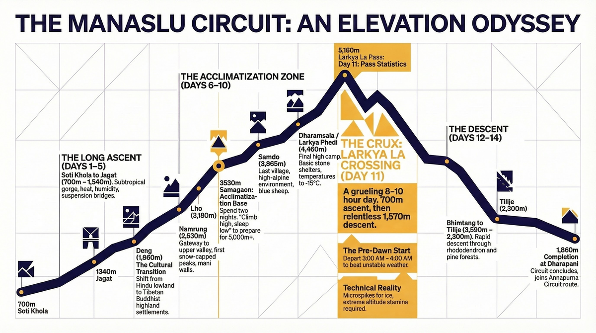
Larkya La Pass represents the physical and emotional climax of the Manaslu Circuit. This isn't a gentle crossing—it's a demanding 10-hour day that begins at 3:00-4:00 AM and tests everything you've built during your acclimatization. For a deep dive on conditions, timing, and crossing strategy, see our dedicated Larkya La Pass guide.
The Pass Day Reality:
- Start Time: 3:00-4:00 AM from Dharamsala (essential to beat weather)
- Total Hiking Time: 8-10 hours
- Elevation Gain: 700m ascent to pass
- Elevation Loss: 1,570m descent to Bhimtang
- Distance: 16 km through snow, moraine, and steep terrain
- Weather Window: Morning offers stable conditions; afternoon clouds/snow common
Technical Requirements:
The pass crossing requires no technical mountaineering skills but demands:
- Excellent physical fitness (ability to hike 8+ hours at extreme altitude)
- Proper acclimatization (following the recommended schedule is non-negotiable)
- Quality cold-weather gear (temperatures can drop to -20°C)
- Microspikes or light crampons (ice/snow common year-round)
- Trekking poles (essential for steep descent)
- Headlamp (pre-dawn start in complete darkness)
Larkya La Pass Risks
This pass claims lives every year from altitude sickness and hypothermia. Never attempt the crossing if you have AMS symptoms, and always turn back if weather deteriorates rapidly. Your guide's judgment on pass conditions is final—this is not negotiable.
Best Timing for the Pass Crossing
Optimal conditions:
- Late September to mid-November: Clearest skies, cold but stable
- April to mid-May: Warming weather, possible afternoon snow
- Avoid: December-February (extreme cold, heavy snow), June-August (monsoon, dangerous conditions)
The crossing experience:
The pre-dawn start reveals a universe of stars before headlamps illuminate the moraine trail. As dawn breaks, Manaslu's north face emerges in alpenglow—a moment most trekkers describe as life-changing. The pass itself is marked with prayer flags, and on clear mornings, views extend to Annapurna II, Himlung Himal, and Cheo Himal.
The descent to Bhimtang is relentless—1,570m over rocky, sometimes icy terrain that punishes knees and concentration. But reaching Bhimtang's meadows with Manaslu's western face towering above marks a profound accomplishment.
Complete 14-Day Manaslu Circuit Itinerary
This itinerary includes two essential acclimatization days. Cutting these days dramatically increases altitude sickness risk and reduces pass-crossing safety margins. Prefer a day-by-day planner? Use our 14-day Manaslu Circuit itinerary or the extended 17-day itinerary with extra acclimatization.
Day 1: Kathmandu to Machha Khola (870m)
- Travel time: 7-9 hours by bus/jeep
- Accommodation: Basic teahouse
- Highlight: Scenic drive along Budhi Gandaki River
The journey begins with an early departure from Kathmandu. The road follows the Trisuli River before turning north into the Gorkha district. The final section involves a rough, winding road that tests vehicle and passenger alike. Machha Khola ("Fish River") is a small settlement marking the official trek start.
Logistics:
- Bus/jeep arranged by trekking agency (typically included)
- Pack lunch recommended (limited roadside options)
- Evening permit check at local checkpoint
Day 2: Machha Khola to Jagat (1,340m)
- Trek duration: 6-7 hours
- Elevation gain: +470m
- Terrain: River valley, suspension bridges, rocky trail
Your first full trekking day establishes the Manaslu rhythm. The trail follows the dramatic Budhi Gandaki gorge, crossing suspension bridges and passing through subtropical forest. The heat at these lower elevations can be intense—start early and carry sufficient water.
Information current as of January 2025.
Machha Khola
870m
Trek starting point. Limited amenities—bring essentials from Kathmandu.
Jagat
1,340m
Last ATM was in Kathmandu. Permit verification required here—entering restricted area.
Day 3: Jagat to Deng (1,860m)
- Trek duration: 6-7 hours
- Elevation gain: +520m
- Terrain: Gorge trail, waterfalls, suspension bridges
The trail continues through the spectacular Budhi Gandaki gorge, with towering cliffs on either side. Multiple suspension bridges cross the river as the path alternates between banks. Watch for beautiful waterfalls cascading from the canyon walls.
Key landmarks:
- Salleri: Small settlement with teahouses
- Philim: Larger Gurung village (alternative lunch stop)
- Numerous suspension bridges—some quite dramatic
Day 4: Deng to Namrung (2,630m)
- Trek duration: 6-7 hours
- Elevation gain: +770m
- Terrain: Steepening valley, forest, first views of snow peaks
The cultural transition begins. As you climb higher, the landscape opens and the first significant mountain views appear. The architecture shifts toward Tibetan-style flat-roofed stone houses, and Buddhist influence becomes visible in mani walls and prayer flags.
Notable features:
- Ghap: Landslide-prone area (caution required)
- First glimpses of Sringi Himal and Ganesh Himal
- Transition from Hindu to Buddhist cultural zones
Day 5: Namrung to Lho (3,180m)
- Trek duration: 4-5 hours
- Elevation gain: +550m
- Terrain: Valley broadens, yak pastures, monastery visits possible
A shorter day allows altitude adjustment. The valley opens dramatically, revealing the first clear views of Manaslu. Lho village offers excellent sunset views and an active monastery worth visiting.
Highlights:
- First clear Manaslu views (weather permitting)
- Lho Gompa (monastery) visit recommended
- Transition to high-altitude landscape
- Tibetan architecture dominates
Day 6: Lho to Samagaon (3,530m)
- Trek duration: 4-5 hours
- Elevation gain: +350m
- Terrain: Alpine valley, glacial moraine edges, Buddhist monuments
Samagaon (also spelled Sama) is the largest village on the trek and serves as the acclimatization base. The setting is spectacular—Manaslu dominates the skyline, and the village preserves strong Tibetan cultural traditions.
Information current as of January 2025.
Lho
3,180m
Active Buddhist monastery. Excellent Manaslu views at sunset.
Samagaon (Sama)
3,530m
Room: NPR 300-500
Dal Bhat: NPR 600-800
Largest village on trek. Best teahouse facilities. Acclimatization base. Wi-Fi available (paid).
Day 7: Acclimatization Day at Samagaon
- Activities: Day hikes to Pungyen Monastery or Birendra Lake
- Max altitude: Up to 4,400m (depending on chosen hike)
- Purpose: Critical acclimatization before high camps
Do not skip this day. Proper acclimatization here determines your success at Larkya La. The "climb high, sleep low" principle applies—gain altitude during the day, return to sleep at 3,530m.
Recommended acclimatization options:
- Pungyen Monastery (3,870m): 3-4 hour round trip, stunning Manaslu views
- Birendra Lake (3,450m): 2-3 hour round trip, glacial lake with reflections
- Manaslu Base Camp (4,800m): 7-8 hours round trip, serious day for fit trekkers only
Pro Tip
The Manaslu Base Camp side trip is demanding and only recommended if you're feeling strong with zero altitude symptoms. Most trekkers find the Pungyen Monastery hike provides excellent acclimatization without overexertion before the challenging days ahead.
Day 8: Samagaon to Samdo (3,865m)
- Trek duration: 3-4 hours
- Elevation gain: +335m
- Terrain: High alpine valley, yak pastures, approaching Tibet border
A short day allows continued acclimatization. Samdo is the last significant village before Dharamsala and sits near the Tibetan border. The landscape here feels austere and remote—you're now truly in the high Himalaya.
Village character:
- Strong Tibetan influence (many residents are ethnic Tibetans)
- Traditional stone houses with juniper wood beams
- Blue sheep often visible on surrounding hillsides
- Clear views toward Tibet
Day 9: Acclimatization/Rest Day at Samdo
- Activities: Rest or optional hike toward Tibetan border
- Max altitude: Up to 4,500m (border viewpoint)
- Purpose: Final acclimatization before Larkya La attempt
Another essential rest day. Options include complete rest or a hike toward the Tibetan border viewpoint (approximately 4-5 hours round trip). This is your last opportunity to gauge fitness before the pass crossing.
Border area notes:
- Views into Tibet from high ridges
- No actual border crossing permitted
- Ancient trade route history
- Possible wildlife sightings (blue sheep, marmots)
Day 10: Samdo to Dharamsala/Larkya Phedi (4,460m)
- Trek duration: 4-5 hours
- Elevation gain: +595m
- Terrain: High alpine, moraine, basic accommodation
The pre-pass camp. Dharamsala (also called Larkya Phedi) offers only basic shelter—dormitory-style accommodation in a stone building. Temperatures drop dramatically after sunset, often reaching -15°C or colder.
Preparation for pass day:
- Early dinner (5:00-6:00 PM)
- Prepare all gear for pre-dawn start
- Sleep in base layers to minimize morning delay
- Fill water bottles (they may freeze overnight)
- Discuss weather and departure time with guide
Dharamsala Conditions
This is not a comfortable night. Expect shared sleeping quarters, basic or no heating, and freezing temperatures. Mental preparation matters as much as physical gear. The reward comes tomorrow.
Day 11: Dharamsala to Bhimtang via Larkya La Pass (5,160m)
- Trek duration: 8-10 hours
- Elevation change: +700m ascent, -1,570m descent
- Terrain: Snow, ice, moraine, rocky descent
The defining day. A 3:00-4:00 AM start allows passage during optimal weather windows. The ascent traverses glacial moraine before steepening toward the prayer flag-draped pass. Summit views on clear mornings include Manaslu, Himlung, Cheo Himal, and Annapurna II.
The descent is relentless—nearly 1,600m of drop over rocky, sometimes icy terrain. Trekking poles are essential. Reaching Bhimtang's meadows with Manaslu's western face towering overhead marks a profound accomplishment.
Pass crossing tips:
- Follow your guide closely—navigation can be difficult in poor visibility
- Microspikes essential for icy sections
- Carry emergency supplies (extra layers, food, water)
- Turn back if altitude symptoms develop
- Celebrate at the top, but don't linger (weather can change rapidly)
Day 12: Bhimtang to Tilije (2,300m)
- Trek duration: 6-7 hours
- Elevation loss: -1,290m
- Terrain: Alpine meadows to forest, dramatic valley views
The journey winds down through changing landscapes. From Bhimtang's high meadows, the trail descends through rhododendron and pine forests, eventually reaching terraced farmland. The contrast with yesterday's arctic conditions is remarkable.
Highlights:
- Final views of Manaslu's western face
- Transition through multiple climate zones
- Return of greenery and warmer temperatures
Day 13: Tilije to Dharapani (1,970m)
- Trek duration: 5-6 hours
- Elevation loss: -330m
- Terrain: Valley floor, joining Annapurna Circuit route
The trail joins the Marsyangdi Valley and connects with the Annapurna Circuit route at Dharapani. This marks the end of the Manaslu-specific trail. Some trekkers continue into the Annapurna region; most return to Kathmandu.
Day 14: Dharapani to Kathmandu
- Travel time: 8-10 hours by jeep/bus
- Route: Via Besisahar and Prithvi Highway
The final journey returns to Kathmandu along the scenic Prithvi Highway. Arrival typically by evening, allowing time for a celebratory dinner and gear return.
Logistics:
- Jeep/bus to Besisahar (2-3 hours)
- Bus to Kathmandu (6-7 hours)
- Arrival typically 5:00-7:00 PM
Permit Requirements: The Complete Guide
Understanding Manaslu's Restricted Area Status
Manaslu's restricted area designation requires specific permits and guided travel. This isn't merely bureaucracy—the system limits visitor numbers, supports local communities, and maintains trail infrastructure. For step-by-step application details and current fees, see our Manaslu Restricted Area Permit guide and the broader Manaslu Conservation Area guide.
Required Permits (2026)
| Permit | Cost (Peak Season) | Cost (Off-Season) | Duration | Where to Obtain |
|---|---|---|---|---|
| Restricted Area Permit (RAP) | $100 per 7 days | $75 per 7 days | Per 7-day period | Department of Immigration (Kathmandu) |
| Manaslu Conservation Area Permit (MCAP) | NPR 3,000 (~$22) | NPR 3,000 (~$22) | Duration of trek | Nepal Tourism Board |
| TIMS Card | NPR 2,000 (individual) | NPR 1,000 (agency) | Duration of trek | Nepal Tourism Board |
| Annapurna Conservation Area Permit (ACAP) | NPR 3,000 (~$22) | NPR 3,000 (~$22) | If exiting via Dharapani | Nepal Tourism Board |
Total permit cost: $150-200 depending on season and trek duration
Critical Regulations
Mandatory Requirements
Guide Required: All Manaslu trekkers must be accompanied by a registered trekking guide. Solo trekking is not permitted in the restricted area.
Minimum Group Size: Officially, two trekkers minimum are required. Solo travelers can be paired by agencies or pay a single supplement.
Agency Arrangement: Permits must be arranged through a registered trekking agency. Independent permit applications are not accepted.
Peak vs. Off-Peak Seasons
- Peak Season (September-November, March-May): $100 per 7 days for RAP
- Off-Peak Season (December-February, June-August): $75 per 7 days for RAP
Most treks require 14+ days, meaning two 7-day RAP periods.
Permit Checkpoints
Your permits will be verified at multiple locations:
- Jagat (entering restricted area)
- Namrung (upper restricted zone)
- Dharapani (exit checkpoint)
Keep waterproof copies of all permits accessible throughout the trek.
For comprehensive permit information, see our Nepal Trekking Permits Guide.
Cost Breakdown: Budget Analysis
Complete Cost Framework (2026)
A guided Manaslu Circuit trek typically costs $1,800-3,000 per person for a standard package, with budget group trips starting near $1,400 and premium private trips reaching $3,500-5,000+. For a line-by-line breakdown, see our Manaslu Circuit cost breakdown.
| Budget Level | Total Cost | What It Includes |
|---|---|---|
| Budget | $1,800-2,200 | Shared group, basic teahouses, minimal extras |
| Mid-Range | $2,400-3,000 | Private guide, better teahouses, porter support |
| Premium | $3,500-5,000+ | Private trip, helicopter backup, best lodges |
Detailed Expense Breakdown
Permit Costs:
- Restricted Area Permit: $100-200 (depending on duration and season)
- MCAP: ~$22
- ACAP (if needed): ~$22
- TIMS: NPR 2,000
- Permit subtotal: $150-250
Guide and Porter:
- Licensed guide: $25-35/day (mandatory)
- Porter: $20-25/day (optional but recommended)
- 14-day guide: $350-500
- 14-day porter: $280-350
Accommodation and Food:
- Teahouse room: NPR 300-500/night ($2-4)
- Dal Bhat: NPR 600-900 ($4-7)
- Other meals: NPR 400-700 ($3-5)
- Daily food/lodging: $15-25/day
- 14-day total: $210-350
Transportation:
- Kathmandu to Machha Khola: $30-50 (shared jeep)
- Dharapani to Kathmandu: $30-50 (shared jeep)
- Transport subtotal: $60-100
Extras:
- Hot showers: NPR 200-500 ($1.50-4)
- Device charging: NPR 200-500 ($1.50-4)
- WiFi: NPR 300-500 ($2-4)
- Snacks/drinks: Variable
- Extras estimate: $50-100
Tips (Culturally Expected):
- Guide: $15-20/day = $210-280 total
- Porter: $10-15/day = $140-210 total
- Tips subtotal: $350-500
Total Budget Summary
| Category | Budget | Mid-Range | Premium |
|---|---|---|---|
| Permits | $150 | $200 | $200 |
| Guide | $350 | $450 | $600 |
| Porter | $0 (carry own) | $300 | $350 |
| Food/Lodging | $210 | $300 | $400 |
| Transport | $60 | $80 | $150 |
| Extras | $50 | $80 | $150 |
| Tips | $200 | $400 | $500 |
| TOTAL | $1,020 | $1,810 | $2,350 |
Note: These are on-trek costs only. Add international flights, Kathmandu hotels, gear, and insurance.
Why Manaslu Costs More Than EBC
The Restricted Area Permit ($100-200) significantly exceeds EBC's permit costs (~$45). However:
- Teahouse prices are generally lower on Manaslu
- Competition keeps food costs reasonable
- Total trek cost often similar to or less than EBC
Pro Tip
Budget travelers: The permit costs are non-negotiable, but teahouse prices on Manaslu are often more reasonable than the heavily-touristed EBC route. Where EBC teahouses charge $8-12 for Dal Bhat, Manaslu teahouses often charge $5-7 for similar meals.
Difficulty Assessment
Understanding the Challenge
The Manaslu Circuit earns its "Difficult" rating through several factors:
- Duration: 14-18 days of consecutive trekking with limited rest
- Altitude: Extended time above 3,500m, passing above 5,000m
- Larkya La Pass: Single demanding day at extreme altitude
- Terrain: Rocky trails, suspension bridges, glacier moraine
- Facilities: Basic teahouses, limited heating, shared bathrooms
- Remoteness: Limited emergency evacuation options in some sections
Physical Fitness Requirements
Minimum fitness baseline:
- Walk 20+ km on varied terrain without exhaustion
- Handle 1,000m+ elevation gain in a single day
- Trek 6-8 hours daily for 12+ consecutive days
- Previous multi-day trekking experience strongly recommended
- Comfort with altitudes above 4,000m (or willingness to properly acclimatize)
Recommended training program (12-16 weeks):
| Weeks | Cardio | Strength | Hiking |
|---|---|---|---|
| 1-4 | 40 min, 3x/week | Squats, lunges 2x/week | Weekend day hike (3-4 hrs) |
| 5-8 | 50 min, 4x/week | Add stairs, step-ups, loaded carries | Weekend hike (5-6 hrs) |
| 9-12 | 60 min, 4x/week | Weighted pack training (10-15 kg) | Back-to-back day hikes |
| 13-16 | Maintain intensity | Taper strength work | Multi-day backpacking (2-3 nights) |
Altitude Sickness Considerations
At Manaslu altitudes, Acute Mountain Sickness (AMS) affects most trekkers to some degree. The key is recognition and response.
AMS Warning Signs:
| Severity | Symptoms | Required Action |
|---|---|---|
| Mild | Headache, fatigue, reduced appetite, mild nausea | Rest, hydrate, monitor overnight |
| Moderate | Severe headache not relieved by medication, vomiting, significant fatigue | Do NOT ascend; consider descent |
| Severe | Confusion, ataxia (difficulty walking straight), breathlessness at rest | IMMEDIATE DESCENT; medical emergency |
Golden Rules:
- Ascend no more than 300-500m sleeping altitude per day above 3,000m
- Include acclimatization days at Samagaon and Samdo
- "Climb high, sleep low" during acclimatization hikes
- Hydrate constantly (3-4 liters per day)
- Avoid alcohol and sleeping pills above 3,000m
- If symptoms worsen, descend immediately
For detailed altitude safety protocols, see our Altitude Sickness Prevention Guide.
Nepal Tourism Police
24/7 emergency line
Himalayan Rescue Association (Kathmandu)
Altitude medicine expertise
CIWEC Clinic (Kathmandu)
Western-standard medical care
Helicopter evacuation cost: $3,000-6,000 USD (higher from remote Manaslu locations)
CRITICAL: Verify your policy covers helicopter evacuation to 6,000m altitude AND covers the Manaslu restricted area. Some policies exclude restricted zones. Confirm coverage in writing before departure.
Best Time to Trek Manaslu
| Month | High | Low | Conditions | Crowds | Notes |
|---|---|---|---|---|---|
| January | -5°C | -20°C | 20mm | Very Low | Extreme cold, heavy snow, some teahouses closed, Larkya La often impassable |
| February | -2°C | -18°C | 25mm | Very Low | Still very cold, improving conditions late month, limited services |
| MarchBest | 3°C | -12°C | 40mm | Low | Spring begins, warming temps, possible snow at pass, fewer trekkers |
| AprilBest | 7°C | -8°C | 60mm | Moderate | Good conditions, rhododendrons blooming lower, occasional afternoon snow |
| MayBest | 10°C | -5°C | 90mm | Moderate | Warmest pre-monsoon, increasing afternoon clouds, spring flowers |
| June | 8°C | -2°C | 200mm | Very Low | Pre-monsoon rains begin, reduced visibility, leeches at lower elevations |
| July | 7°C | 0°C | 350mm | Very Low | Full monsoon, trails dangerous, landslide risk, not recommended |
| August | 8°C | 0°C | 320mm | Very Low | Monsoon continues, poor conditions, limited services |
| SeptemberBest | 8°C | -5°C | 150mm | Moderate | Monsoon ending, clearing skies, some rain possible early month |
| OctoberBest | 6°C | -10°C | 35mm | High | Peak season, best visibility, stable weather, busiest month |
| NovemberBest | 2°C | -15°C | 15mm | Moderate | Excellent weather, cooling temps, clearer than October, fewer crowds |
| December | -2°C | -18°C | 15mm | Low | Cold but clear early month, snow increases, some teahouses closing |
Prime Trekking Windows
Autumn (September-November): The premier season. Post-monsoon clarity offers the best mountain views, stable weather patterns, and comfortable temperatures at lower elevations. October is peak season with the best overall conditions; November offers similar weather with fewer crowds and colder nights. For a month-by-month breakdown, see our Manaslu Circuit best time guide, and for a complete season-by-season analysis across Nepal, see Best Time to Trek Nepal.
Spring (March-May): Warming temperatures and blooming rhododendrons at lower elevations create a beautiful trek. April-May offers good conditions, though afternoon clouds are more common than autumn. Late May brings pre-monsoon warmth but increasing instability.
Season Comparison
| Factor | Autumn (Sept-Nov) | Spring (Mar-May) |
|---|---|---|
| Visibility | Excellent (clearest skies) | Good (afternoon clouds common) |
| Temperature | Cool to cold | Warmer (especially May) |
| Precipitation | Minimal | Moderate (increasing toward monsoon) |
| Crowds | Peak (October) to Moderate | Moderate throughout |
| Flowers | Limited | Rhododendrons, spring blooms |
| Pass Conditions | Generally clear | Possible snow |
| Teahouse Availability | All open | All open |
Seasons to Avoid
Monsoon (June-August): Trail conditions become dangerous with landslides, swollen rivers, and slippery paths. Leeches appear at lower elevations. Cloud cover eliminates mountain views. Not recommended under any circumstances.
Deep Winter (December-February): Extreme cold at altitude, heavy snowfall possible, Larkya La may be impassable. Some teahouses close. Only for experienced cold-weather trekkers with proper equipment and flexibility.
Day-by-Day Trail Guide
Lower Valley Section (Days 1-4)
Character: Subtropical gorge, suspension bridges, Hindu-Buddhist transition
The journey begins in the dramatic Budhi Gandaki gorge—Nepal's deepest canyon. The trail follows the river north through subtropical forest, crossing suspension bridges that span the turquoise waters. Villages display a gradual cultural transition from Hindu lowland communities to Buddhist highland settlements.
Key landmarks:
- Tatopani: Natural hot springs (clothing optional bathing common)
- Philim: Large Gurung village, significant permit checkpoint
- Multiple dramatic suspension bridges (some quite high and narrow)
Trail challenges:
- Heat and humidity at lower elevations
- Rocky, uneven terrain throughout
- Steep sections between river crossings
- Afternoon sun exposure
Mid-Valley Section (Days 5-7)
Character: Tibetan Buddhist villages, opening views, acclimatization base
The valley opens dramatically above Namrung, revealing snow peaks and traditional stone villages. Architecture shifts to Tibetan-style flat roofs, mani walls line the trail, and prayer flags flutter from every high point. Samagaon serves as the cultural and logistical heart of the trek.
Cultural highlights:
- Lho Gompa: Active monastery with daily prayers
- Samagaon monastery and Buddhist art
- Traditional Tibetan stone houses
- Mani walls and prayer wheels throughout
Acclimatization activities:
- Pungyen Monastery day hike
- Birendra Lake visit
- Optional Manaslu Base Camp excursion (demanding)
Upper Valley Section (Days 8-10)
Character: High alpine terrain, Tibet border proximity, pre-pass preparation
Above Samagaon, the landscape becomes stark and austere. Samdo village maintains strong Tibetan connections (many residents are ethnic Tibetans who crossed the border generations ago). The trail to Dharamsala traverses barren moraine—a moonscape of glacial debris.
Wildlife opportunities:
- Blue sheep (bharal) commonly visible on hillsides
- Himalayan marmots in meadows
- Occasional snow leopard signs (sightings rare but possible)
- Golden eagles and lammergeiers overhead
Preparation notes:
- Last reliable water sources before pass
- Final opportunity to assess fitness and symptoms
- Gear organization for pass day essential
Larkya La Crossing (Day 11)
Character: High alpine crossing, glacial terrain, technical demands
The pass day is detailed extensively in the Larkya La section above. This is the physical and emotional climax of the entire trek—a demanding 10-hour traverse from arctic pre-dawn conditions to the meadows of Bhimtang.
Descent and Exit (Days 12-14)
Character: Rapid descent, landscape transitions, return to civilization
The post-pass days offer stunning contrasts as you descend through climate zones: alpine meadows give way to rhododendron forest, then pine, then oak, and finally terraced farmland. The trail joins the Annapurna Circuit at Dharapani, offering continuation options or the journey home.
Highlights:
- Final Manaslu views from Bhimtang meadows
- Forest transitions through multiple zones
- Traditional villages of the Marsyangdi Valley
- Optional extension into Annapurna region
Cultural Highlights: Tibetan Buddhist Heritage
Nubri and Tsum Valleys: Living History
The Manaslu region encompasses two significant cultural zones:
Nubri Valley (main trek route): The villages from Lho to Samdo maintain strong Tibetan Buddhist traditions. Residents speak a Tibetan dialect, practice Tibetan Buddhism, and maintain cultural connections across the border.
Tsum Valley (optional extension): A hidden valley branching from the main route, Tsum is considered a "beyul" (sacred hidden valley) in Tibetan Buddhist tradition. Adding 4-7 days to your trek, the Tsum Valley offers unparalleled cultural immersion.
Religious Landmarks
Key monasteries and sacred sites:
- Lho Gompa: Active monastery with resident monks, daily prayers open to visitors
- Pungyen Monastery: High above Samagaon, spectacular setting with Manaslu views
- Ribung Gompa: Near Samagaon, significant religious site
- Mu Gompa (Tsum Valley): One of Nepal's largest nunneries
Cultural etiquette:
- Walk clockwise around mani walls and stupas
- Remove shoes before entering monastery prayer halls
- Ask permission before photographing monks or ceremonies
- Small donations appreciated but not expected
- Modest dress appropriate at religious sites
Traditional Villages
The trek passes through distinct settlement types:
Lower valley (Hindu-influenced):
- Slate-roofed houses
- Hindu temples alongside Buddhist elements
- Gurung and Tamang ethnic communities
Upper valley (Tibetan-influenced):
- Flat-roofed stone houses with stacked firewood
- Buddhist monasteries as village centers
- Prayer flags on every high point
- Tibetan ethnic communities (Nubri, Tsum)
The Manaslu Teahouse Experience
Unlike the commercialized lodges of EBC or Annapurna, Manaslu teahouses maintain a traditional character:
- Communal dining rooms with wood or yak-dung stoves
- Basic but adequate rooms (thin walls, minimal heating)
- Limited menu variety (Dal Bhat reigns supreme)
- Genuine cultural exchange with teahouse families
- Prices set more by subsistence than profit
Manaslu vs. EBC vs. Annapurna: Detailed Comparison
Which Trek Is Right for You?
| You Should Choose... | If You Want... |
|---|---|
| Manaslu | Remoteness, cultural authenticity, fewer crowds, challenge |
| Everest Base Camp | Iconic destination, better facilities, Sherpa culture, first Himalayan trek |
| Annapurna Circuit | Diversity, road access options, moderate challenge, good infrastructure |
| Annapurna Base Camp | Shorter trek, lower altitude, excellent views, easier logistics |
Feature Comparison
| Feature | Manaslu Circuit | EBC | Annapurna Circuit |
|---|---|---|---|
| Duration | 14-18 days | 12-16 days | 12-21 days |
| Max Altitude | 5,160m | 5,364m | 5,416m |
| Permit Cost | $150-200 | $45-50 | $40-45 |
| Guide Required | Yes (mandatory) | Yes (since 2026) | Recommended |
| Teahouse Quality | Basic | Good-Excellent | Good-Excellent |
| Cultural Focus | Tibetan Buddhist | Sherpa | Diverse (Hindu, Buddhist) |
| Crowds (Peak) | Low | High | Moderate-High |
| Technical Difficulty | High (Larkya La) | Moderate | Moderate (Thorong La) |
| Emergency Access | Limited | Good | Good |
| WiFi Availability | Limited | Widespread | Widespread |
Pro Tip
Many experienced trekkers consider Manaslu the "graduate-level" Nepal trek—best appreciated after experiencing EBC or Annapurna. The basic facilities and remote character that make Manaslu special can frustrate first-time Nepal visitors expecting more infrastructure.
Side Trips and Extensions
Manaslu Base Camp (4,800m)
From Samagaon, 7-8 hours round trip
A demanding day hike to the base of Manaslu's south face. The trail traverses moraine and glacial debris to reach the climbers' base camp. Only attempt this if fully acclimatized and feeling strong—the elevation gain is significant.
What to expect:
- Close views of Manaslu's south face and glaciers
- Expedition tent camps during climbing season (April-May)
- Austere, dramatic high-mountain landscape
- 6-8 hours of challenging hiking
Birendra Lake (3,450m)
From Samagaon, 2-3 hours round trip
A sacred glacial lake offering stunning Manaslu reflections on calm mornings. Named after the late King Birendra, this accessible side trip provides excellent acclimatization without excessive exertion.
Tsum Valley Extension
4-7 additional days
The hidden valley of Tsum branches from the main route at Chhekampar (below Jagat) and penetrates deep into a sacred Buddhist landscape. This popular Manaslu plus Tsum Valley combination offers:
- Mu Gompa, one of Nepal's largest nunneries
- Unspoiled Tibetan culture with minimal outside influence
- Stunning valley views and high passes
- Fewer trekkers than the main circuit
Requirements:
- Additional Tsum Valley permit ($35/week)
- 4-7 extra days minimum
- Same guide/group requirements as main circuit
Annapurna Circuit Continuation
From Dharapani, trekkers can continue into the Annapurna Circuit rather than returning to Kathmandu. This epic combination covers both circuits in 20-25 days, crossing both Larkya La and Thorong La passes.
Frequently Asked Questions
Permits and Logistics
How many days does the Manaslu Circuit Trek take? Most trekkers complete the classic Manaslu Circuit in 14-16 days from Kathmandu to Kathmandu, including two acclimatization days. Add 4-7 days for the Tsum Valley extension (18-21 days total) or shave a day or two with a fit group and a jeep exit from Dharapani.
Is the Manaslu Circuit harder than Everest Base Camp? Yes, modestly. Manaslu involves longer daily distances, more elevation variation, more basic teahouses, and a single demanding pass day at Larkya La (5,160m). EBC reaches a higher point (5,364m at Kala Patthar) but has gentler daily terrain and better infrastructure. Manaslu suits trekkers who have already done EBC or Annapurna.
Can I trek the Manaslu Circuit independently without a guide? No. Restricted-area regulations require every trekker to be accompanied by a licensed guide arranged through a registered agency. Fully independent (guide-free) trekking is not permitted and is strictly enforced at checkpoints.
Can I trek Manaslu solo (one person)? You cannot trek the restricted area entirely alone, but you can travel as a single client with a licensed guide. Officially two trekkers are required; solo travelers are typically paired with another client by the agency or pay a single supplement to trek with their own guide.
How far in advance should I book? For peak season (October-November), book 4-8 weeks ahead. Spring season allows more flexibility. Off-season treks can sometimes be arranged on short notice.
What if I need to evacuate due to illness? Helicopter evacuation is possible but limited by weather and terrain. Insurance covering evacuation is mandatory. The most reliable extraction points are Samagaon and Bhimtang. Be aware that evacuation from Dharamsala or the pass itself may be impossible.
Physical Preparation
How fit do I need to be for Manaslu? Very fit. You should be able to hike 6-8 hours daily for 12+ consecutive days, handle 1,000m+ elevation gains, and feel confident at altitude. Previous multi-day trekking experience is strongly recommended.
Is prior altitude experience necessary? Not mandatory, but helpful. If this is your first high-altitude trek, allow extra acclimatization days and be conservative with your pace. Consider a "training trek" at lower elevation first—the Langtang Valley or Annapurna Base Camp are excellent options.
Can I train for the altitude at home? Not effectively for the physiological demands of 5,000m+. What you can train is cardiovascular fitness and leg strength, which help enormously. The actual altitude adaptation happens on the trek.
What's the hardest day? Day 11 (Larkya La crossing) is universally considered the most demanding—8-10 hours of hiking, pre-dawn start, extreme altitude, and a brutal descent. Days 3-4 (lower valley ascents in heat) are also challenging for different reasons.
Weather and Timing
What temperatures should I expect? At Samagaon (3,530m) in peak season: daytime highs around 8-12°C, nighttime lows -10°C to -15°C. At Dharamsala (4,460m): nighttime lows can reach -20°C. Lower elevations (below 2,000m) can be quite warm—20°C+ during the day.
Can I trek Manaslu in December? Early December offers cold but potentially clear conditions. Late December brings increasing snow and cold that most trekkers find uncomfortable. Some teahouses may close. Not recommended unless you're experienced with cold-weather trekking.
What happens if the pass is closed? Weather can close Larkya La temporarily. Options include waiting (if conditions look promising), returning via the same route (no pass crossing), or helicopter evacuation if you must exit. Flexible itineraries help—build in buffer days.
Accommodation and Food
What are the teahouses like? Basic but functional. Expect shared bathrooms, thin walls, minimal heating (sometimes none), and simple beds. Hot showers cost extra and aren't always available. Dining rooms with wood stoves provide communal warmth.
What food is available? Dal Bhat (rice, lentils, vegetables) is the staple and best value. Noodles, momos (dumplings), fried rice, eggs, and basic Western dishes are available. Menu variety decreases at higher elevations. Vegetarian options readily available; vegan more challenging.
Is WiFi available? Limited. Samagaon has paid WiFi (often slow and unreliable). Lower villages increasingly offer connectivity. Don't expect consistent internet—embrace the disconnection.
Can I charge devices? Yes, for a fee at most teahouses (NPR 200-500 per device). Solar charging diminishes at higher elevations and in poor weather. Bring backup batteries or a solar charger.
Budget and Money
How much cash should I bring? NPR 50,000-75,000 ($380-570) covers most scenarios for a 14-day trek including extras, hot showers, charging, snacks, and tips. Bring extra as a safety buffer—there are no ATMs after Kathmandu.
Can I pay by card anywhere? Essentially no. Cash only throughout the trek. Some Kathmandu agencies accept cards for initial bookings.
What about tipping? Tips are culturally expected and appreciated. Guidelines: $15-20/day for guides, $10-15/day for porters. For a 14-day trek, budget $350-500 total for tips.
Health and Safety
Do I need altitude medication? Discuss with your doctor before departure. Acetazolamide (Diamox) is commonly prescribed as a preventive measure. It helps with acclimatization but doesn't mask serious symptoms—you'll still know if you're developing significant AMS.
What vaccinations do I need? Consult a travel medicine specialist. Typically recommended: Hepatitis A, Typhoid, Tetanus, routine immunizations. Consider: Hepatitis B, Rabies, Japanese Encephalitis depending on your broader travel plans.
Is the water safe to drink? Never drink untreated water. Options: purification tablets (chlorine or iodine), UV treatment (SteriPen), water filter, or boiled water (available at teahouses for a fee). Avoid ice in drinks.
What if I get sick on the trek? Minor illness (colds, stomach issues) can often be managed with rest and medication. Serious illness requires descent and possible evacuation. Travel insurance with emergency coverage is non-negotiable.
Route Variations
Can I do a shorter version of the Manaslu Circuit? Not meaningfully. The circuit requires crossing Larkya La—there's no shortcut. You can reduce some acclimatization days (not recommended) or arrange helicopter exit from Bhimtang (expensive), but the core circuit remains 12-14 days minimum.
What about the Manaslu Base Camp trek without the circuit? Yes, a shorter trek to Manaslu Base Camp and back via the same route is possible. This 10-12 day option avoids Larkya La but misses the dramatic pass crossing. Not the classic experience, but an alternative for those with time constraints.
Can I combine Manaslu with Annapurna Circuit? Yes, the ultimate 20-25 day adventure. From Dharapani, continue north on the Annapurna Circuit, crossing Thorong La (5,416m). This requires excellent fitness and additional permits/time.
Bridge Block: Planning Your Manaslu Trek
Ready to experience Nepal's best-kept trekking secret? Here are your next steps:
- Compare verified operators for Manaslu Circuit
- Nepal trekking permits explained
- Altitude sickness prevention guide
- Best time to trek in Nepal
- What to pack for high-altitude trekking
- Manaslu Region Overview
- Manaslu Circuit packing list
- Larkya La Pass guide
Plan your Manaslu Circuit trek with confidence
Compare verified local agencies, lock in restricted-area permits, and get a realistic 2026 itinerary and cost estimate from people who actually trek this route.
Related Routes
- Everest Base Camp Trek — Nepal's iconic high-altitude journey
- Annapurna Circuit Trek — Classic diversity trek with Thorong La crossing
- Annapurna Base Camp Trek — Shorter, lower-altitude alternative
- Gokyo Lakes Trek — Everest region with fewer crowds
- Langtang Valley Trek — Accessible Himalayan experience near Kathmandu
This guide is maintained by the Nepal Trekking Team with input from verified trekking agencies and local experts. Last updated June 2026. For corrections or updates, contact our editorial team.
The Route
Interactive Route Map
Explore the trek on a topographic map. Tap a waypoint for elevation, accommodation, and day-by-day detail. Scroll to zoom.
Loading interactive map…