


| Route | Duration | Max Altitude | Difficulty | Permits | Teahouses | Crowds |
|---|---|---|---|---|---|---|
| Annapurna Circuit | 12-21 days | 5,416m | Difficult | $40-50 | Excellent | Moderate |
| Everest Base Camp | 12-16 days | 5,364m | Moderate-Challenging | $45-50 | Excellent | High (Peak Season) |
| Manaslu Circuit | 14-18 days | 5,160m | Challenging | $150-200 | Basic-Good | Low |
| Annapurna Base Camp | 7-12 days | 4,130m | Moderate | $40-45 | Excellent | Moderate-High |
Annapurna Thorong La Pass Trek: The Complete Circuit Guide
The Annapurna Thorong La Pass trek is the high-crossing version of the Annapurna Circuit, taking you over Thorong La Pass at 5,416m (17,769 ft)—one of the world's highest trekking passes. The full route runs 12-21 days across 160-230 km, climbing from subtropical valleys to high-altitude desert, with proper acclimatization in Manang (3,540m) the key to crossing the pass safely. A licensed guide is mandatory for foreign trekkers in 2026.
The Annapurna Circuit stands as one of the world's greatest long-distance treks, a legendary 160-230 kilometer journey that circumnavigates the entire Annapurna massif. Voted by numerous trekking publications as the world's best long-distance trek, this route takes you through an astonishing diversity of landscapes—from humid subtropical valleys filled with rice paddies and banana trees to the stark, arid high-altitude desert of the Mustang region, all while crossing Thorong La Pass at a breathtaking 5,416 meters.
First opened to foreign trekkers in 1977, the Annapurna Circuit has evolved significantly over the decades. What was once a remote three-week wilderness expedition has been transformed by road construction, yet the core appeal remains intact: the crossing of one of the world's highest trekking passes, immersion in diverse ethnic cultures from Gurung to Thakali to Tibetan, and panoramic views of 8,000-meter giants including Annapurna I (8,091m), Dhaulagiri (8,167m), and Manaslu (8,163m).
This guide provides an honest, comprehensive assessment of the Annapurna Circuit as it exists today—acknowledging the reality of jeep roads while highlighting the magnificent sections that continue to make this trek a bucket-list experience for adventurers worldwide.
Route Snapshot
12-21 days
5,416m (17,769 ft) at Thorong La Pass
4,925m at High Camp
160-230 km depending on route
Difficult
Oct-Nov (Autumn), Mar-May (Spring)
Annapurna Conservation Area
Besisahar (760m) or Chame (2,670m)
Jomsom (2,720m) or Nayapul (1,070m)
ACAP + TIMS
Teahouse/Lodge throughout
Mandatory for foreign trekkers (2026 rule)
Key Route Variants:
| Variant | Duration | Highlights | Best For |
|---|---|---|---|
| Classic Full Circuit | 18-21 days | Complete Besisahar to Nayapul loop | Purists, cultural immersion |
| Standard Circuit | 14-16 days | Skip lower road sections, Chame to Jomsom | Most trekkers, balanced experience |
| Short Circuit | 10-12 days | Manang start, focus on Thorong La | Limited time, fit trekkers |
| Circuit + Tilicho Lake | 16-18 days | Adds world's highest lake detour | Adventurous, extra acclimatization |
| Circuit + Poon Hill | 19-23 days | Extends to Ghorepani sunrise viewpoint | Comprehensive Annapurna experience |
The Road Impact Reality: An Honest Assessment
Let's address the elephant in the room directly: the Annapurna Circuit is no longer the pristine wilderness trail it was in the 1990s. Jeep roads have been constructed along significant portions of the route, particularly on the eastern (Marsyangdi Valley) side. Understanding this reality is essential for planning a satisfying trek.
Current Road Situation (2026)
Heavily Road-Affected Sections:
- Besisahar to Chame (760m to 2,670m): The once-beautiful lower trail now parallels a dusty jeep road. Most trekkers now drive this section.
- Chame to Lower Pisang: Road exists but less trafficked
- Jomsom to Beni/Nayapul: Well-established road, most trekkers fly or drive out
Pristine Trekking Sections (Still Magnificent):
- Upper Pisang to Manang via Ghyaru and Ngawal: The high route remains road-free and spectacular
- Manang to Thorong Phedi: Classic high-altitude trekking, no road access
- Thorong La Pass Crossing: Entirely on foot, the trek's crown jewel
- Muktinath to Kagbeni: Beautiful descent, minimal road impact
- Tilicho Lake Side Trip: Completely road-free wilderness
Strategic Recommendations
The key to enjoying the Annapurna Circuit in 2026 is strategic planning:
- Drive to Chame or Dharapani: Skip the dusty, road-affected lower section
- Take the Upper Route: Choose Upper Pisang over Lower Pisang to avoid roads
- Don't Rush: Extra days allow you to enjoy road-free detours
- Add Tilicho Lake: This pristine side trip adds 2-3 days of pure wilderness trekking
- Fly from Jomsom: Avoid the long, dusty descent to Pokhara
The Silver Lining
Road construction has significantly reduced crowds on the Annapurna Circuit. While the Everest region sees 50,000+ trekkers annually, the AC now sees far fewer visitors—meaning better teahouse availability, more authentic cultural interactions, and a quieter experience on the still-pristine sections.
Natural Annapurna Trekking Trails (NATT)
To counter the spread of jeep roads, Nepalese guide Prem Rai pioneered the Natural Annapurna Trekking Trails (NATT)—a network of way-marked footpaths that deliberately avoid the road wherever possible. With up to 75% of the original circuit affected by road construction, these trails are how experienced trekkers still walk a genuine wilderness route.
- Way-marking: NATT routes are marked with red-and-white blazes for the main trail and blue-and-white blazes for the alternative (off-road) variants
- Where they help most: the lower Marsyangdi Valley (Besisahar to Chame) and the Kali Gandaki side (Jomsom to Tatopani), the two most road-affected stretches
- How to use them: ask your guide to follow NATT variants rather than the jeep track; a good local guide knows which forks keep you off the road
- Free maps: the NATT trail map (the "red and blue" map by Andrees de Ruiter) is widely available in Kathmandu and Pokhara bookshops
Combined with the Upper Pisang high route and a Tilicho Lake detour, NATT trails let you reclaim most of the off-road experience that made this trek world-famous.
Thorong La Pass: The Crown Jewel (5,416m)
The crossing of Thorong La Pass is the defining moment of the Annapurna Circuit—and one of the most memorable experiences in Himalayan trekking. At 5,416 meters (17,769 feet), it's one of the highest trekking passes in the world, and successfully crossing it requires careful preparation, proper acclimatization, and respect for mountain conditions. For pass-day logistics and a stand-alone crossing checklist, see our dedicated Thorong La Pass crossing guide.
Understanding the Challenge
Altitude Statistics:
- Pass Height: 5,416m (17,769 ft)
- Typical Starting Point: Thorong Phedi (4,450m) or High Camp (4,925m)
- Descent to: Muktinath (3,760m)
- Elevation Gain on Pass Day: 470-966m depending on start point
- Total Distance: 12-14 km from Thorong Phedi to Muktinath
- Typical Duration: 7-10 hours total
The Pass Day Experience
Most trekkers start between 4:00-5:00 AM to ensure they cross before afternoon weather deteriorates. The pre-dawn departure from Thorong Phedi or High Camp is a surreal experience—headlamps bobbing in the darkness, frozen ground crunching underfoot, and the gradual revelation of surrounding peaks as dawn breaks.
From Thorong Phedi (6-7 hours to pass):
- Steep initial climb on rocky terrain
- Gradual switchbacks through barren landscape
- False summits that test psychological resolve
- Final push to prayer flag-adorned pass
From High Camp (2.5-3.5 hours to pass):
- Shorter but steeper approach
- Less time in thin air before reaching the top
- Popular choice for those wanting extra acclimatization the night before
Crossing Strategy
Critical: Acclimatization Before Thorong La
Do NOT attempt Thorong La Pass without proper acclimatization. At minimum, spend one full acclimatization day in Manang (3,540m) before proceeding. Two rest days in Manang is even better. Rushing this section significantly increases your risk of Acute Mountain Sickness (AMS), High Altitude Pulmonary Edema (HAPE), or High Altitude Cerebral Edema (HACE).
Optimal Approach:
- Day 1: Arrive Manang, rest
- Day 2: Acclimatization day—hike to Ice Lake (4,620m) or Gangapurna Lake
- Day 3: Trek to Yak Kharka (4,018m)
- Day 4: Trek to Thorong Phedi (4,450m)
- Day 5: Cross Thorong La to Muktinath
Alternative (More Conservative):
- Add a night at High Camp (4,925m) before the pass
- Sleep at lower Thorong Phedi, hike to High Camp and back for acclimatization
- Adds an extra day but significantly increases success rate
Weather Considerations
Thorong La is typically passable from mid-March to late November. However, conditions can change rapidly:
| Season | Typical Conditions | Pass Accessibility |
|---|---|---|
| March-April | Snow possible, cold nights, clearing days | Generally open, snow gear sometimes needed |
| May | Warming, afternoon clouds, pre-monsoon | Open, best weather for crossing |
| June-August | Monsoon, poor visibility, snow/rain | Often closed or very dangerous |
| September | Post-monsoon clearing, possible early snow | Opening up, variable conditions |
| October-November | Best conditions, cold but stable | Optimal window |
| December-February | Heavy snow, extreme cold | Often closed, experienced only |
Pro Tip
The pass is typically crossable by 8-9 AM in good weather. Starting early isn't just about beating crowds—it's about safety. Afternoon clouds, wind, and potential snow make late crossings dangerous. If weather looks bad, your guide should make the call to delay or turn back.
Complete Itinerary Options
Classic 21-Day Itinerary (Full Experience)
This comprehensive itinerary includes all the highlights and allows for proper acclimatization with minimal road sections.
Days 1-2: Kathmandu to Besisahar, Drive to Dharapani
- Drive from Kathmandu to Besisahar (6-7 hours)
- Continue by jeep to Dharapani (1,860m) to skip road-affected lower section
- Alternatively, start trekking from Bulbule for more walking
Days 3-5: Dharapani to Chame to Upper Pisang
- Trek through pine forests and traditional villages
- Enter the Manang Valley with first views of Annapurna II
- Choose Upper Pisang route for spectacular views
Days 6-8: Upper Pisang to Manang via Ghyaru and Ngawal
- This high route is the circuit's hidden gem
- Visit ancient Braga monastery
- Arrive in Manang for acclimatization
Days 9-10: Manang Acclimatization
- Day hikes to Ice Lake (4,620m) or Gangapurna Lake
- Explore Manang village, visit the HHARA clinic
- Optional: Begin Tilicho Lake side trip
Days 11-12: Tilicho Lake Side Trip (Optional but Recommended)
- Trek to Tilicho Base Camp (4,150m)
- Morning hike to Tilicho Lake (4,919m)
- Return to main trail at Yak Kharka
Days 13-14: Yak Kharka to Thorong Phedi to High Camp
- Short trekking days to conserve energy
- Final preparations for pass crossing
Day 15: Thorong La Pass Crossing
- Early start (4:00-5:00 AM)
- Summit Thorong La (5,416m)
- Descend to Muktinath (3,760m)
Days 16-17: Muktinath to Kagbeni to Jomsom
- Visit sacred Muktinath Temple
- Trek through Tibetan-influenced Kagbeni
- Arrive in Jomsom (2,720m)
Days 18-21: Return Options
- Fly Jomsom to Pokhara (25 min) - Recommended
- Continue trekking via Tatopani and Ghorepani for Poon Hill sunrise
- Drive or fly to Kathmandu
Standard 15-Day Itinerary (Most Popular)
For an expanded day-by-day version of this schedule with stage distances and lodge notes, see our Annapurna Circuit 15-day itinerary.
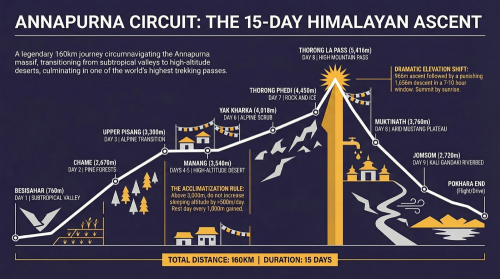
Day 1: Kathmandu to Besisahar, drive to Chame (2,670m) Day 2: Trek Chame to Upper Pisang (3,300m) - 5-6 hours Day 3: Trek Upper Pisang to Manang via Ghyaru (3,540m) - 6-7 hours Day 4: Acclimatization day in Manang Day 5: Trek Manang to Yak Kharka (4,018m) - 3-4 hours Day 6: Trek Yak Kharka to Thorong Phedi (4,450m) - 3-4 hours Day 7: Cross Thorong La Pass (5,416m) to Muktinath (3,760m) - 7-9 hours Day 8: Trek Muktinath to Jomsom (2,720m) - 5-6 hours Day 9: Fly Jomsom to Pokhara Days 10-11: Buffer days for weather delays Days 12-15: Pokhara leisure, return to Kathmandu
Short 12-Day Itinerary (Time-Limited)
Fitness Required
The short itinerary requires excellent physical fitness and prior high-altitude experience. Do not attempt this if you've never trekked above 4,000m before.
Day 1: Fly Kathmandu to Pokhara, drive to Chame Day 2: Trek to Upper Pisang Day 3: Trek to Manang Day 4: Acclimatization day (mandatory—do not skip) Day 5: Trek to Thorong Phedi via Yak Kharka Day 6: Cross Thorong La to Muktinath Day 7: Trek to Jomsom Day 8: Fly Jomsom to Pokhara Days 9-12: Buffer and return to Kathmandu
Day-by-Day Detailed Guide
Section 1: Approach (Days 1-3)
Day 1: Kathmandu to Besisahar, Drive to Dharapani
Logistics:
- 6-7 hour drive from Kathmandu to Besisahar (760m)
- Continue by jeep to Dharapani (1,860m) - 4-5 hours
- Total travel: 10-12 hours
The long drive from Kathmandu follows the Prithvi Highway along the Trisuli River before turning north into the Marsyangdi Valley. Most trekkers now bypass the lower trail sections, which have been significantly impacted by road construction.
Road Avoidance Tip: The jeep ride to Dharapani allows you to skip approximately 3 days of dusty, road-affected trekking. Some purists still walk this section, but the experience has diminished significantly.
Day 2: Dharapani to Chame (2,670m)
Trek Details:
- Distance: 15 km
- Duration: 5-6 hours
- Elevation Gain: +810m
The trail officially enters the Manang district, and the landscape begins its transition from subtropical to temperate. You'll pass through Bagarchap (2,160m) with its Tibetan-style flat-roofed houses and continue through forests of pine and fir.
Cultural Note: Dharapani marks the ethnic boundary between the Hindu lowlands and the Buddhist highlands. From here north, you'll encounter gompa monasteries, prayer wheels, and Tibetan cultural influences.
Day 3: Chame to Upper Pisang (3,300m)
Trek Details:
- Distance: 12 km
- Duration: 5-6 hours
- Elevation Gain: +630m
Chame is the administrative center of Manang district, with the last ATM until Jomsom. The trail continues through apple orchards (try the local apple brandy, but not before trekking) with increasingly impressive views of Annapurna II and Lamjung Himal.
Critical Decision: At Pisang, choose the HIGH route through Upper Pisang. The low route follows the road and misses spectacular scenery. Upper Pisang offers a traditional village atmosphere and superior mountain views.
Information current as of January 2025.
Dharapani
1,860m
Gateway to Manang district. Last lowland village.
Chame
2,670m
Room: NPR 300-500
Dal Bhat: NPR 450-600
District headquarters. Last ATM until Jomsom.
Upper Pisang
3,300m
Room: NPR 300-500
Dal Bhat: NPR 500-700
Spectacular sunrise views of Annapurna II. Choose this over Lower Pisang.
Section 2: The Magnificent Middle (Days 4-6)
This is the Annapurna Circuit at its finest—spectacular mountain scenery, ancient monasteries, and pristine trail conditions away from any road.
Day 4: Upper Pisang to Manang via Ghyaru and Ngawal (3,540m)
Trek Details:
- Distance: 16 km
- Duration: 6-7 hours
- Elevation Gain: +500m (with undulations)
This is arguably the most beautiful day of the entire circuit. The high trail through Ghyaru (3,670m) and Ngawal (3,680m) offers continuous views of Annapurna II, III, and IV, Gangapurna, and Tilicho Peak. The villages themselves are architectural gems—traditional stone houses with flat roofs used for drying grain and hay.
Don't Miss:
- Sunrise at Upper Pisang before departing
- Ancient chortens and mani walls between villages
- Braga monastery (3,439m), one of the region's most impressive
- Views across the valley to the Manang Valley floor
Day 5: Acclimatization Day in Manang
Mandatory rest day. Do not skip.
Manang (3,540m) is a fascinating town that serves as the circuit's cultural and logistical hub. The combination of Tibetan Buddhist traditions and modern trekking infrastructure makes it an ideal place to spend extra time.
Acclimatization Hikes:
- Ice Lake (4,620m): 4-5 hour round trip, spectacular glacial lake
- Gangapurna Lake (3,650m): Easy 1-hour walk, milky blue glacial water
- Praken Gompa (3,760m): Cave monastery above town, 2-hour round trip
Facilities in Manang:
- HRA (Himalayan Rescue Association) clinic with daily altitude talks
- Numerous bakeries and restaurants serving pizza, coffee, and dal bhat
- Gear shops for last-minute purchases
- Internet cafes (slow but functional)
Day 6: Manang to Yak Kharka (4,018m)
Trek Details:
- Distance: 10 km
- Duration: 3-4 hours
- Elevation Gain: +478m
A shorter day that allows continued acclimatization while gaining altitude. The landscape becomes increasingly stark and alpine—juniper scrub gives way to rock and ice. Yak Kharka ("yak pasture") is a small settlement with basic but comfortable lodges.
Alternative: Some trekkers prefer to stay at Letdar (4,200m), slightly higher but with fewer facilities.
Section 3: The High Crossing (Days 7-9)
Day 7: Yak Kharka to Thorong Phedi (4,450m)
Trek Details:
- Distance: 7 km
- Duration: 3-4 hours
- Elevation Gain: +432m
The final approach to Thorong La base camp. Thorong Phedi ("foot of Thorong") sits in a dramatic amphitheater below the pass. The lodges here are well-equipped for the pre-dawn departures, serving dinner as early as 5 PM and breakfast from 3 AM.
High Camp Option: Consider hiking to High Camp (4,925m) in the afternoon and staying there overnight. This shortens the pass day considerably and provides better acclimatization. High Camp facilities are more basic than Thorong Phedi but adequate.
Day 8: Thorong La Pass (5,416m) to Muktinath (3,760m)
The Big Day.
Trek Details:
- Distance: 14 km (from Thorong Phedi) or 10 km (from High Camp)
- Duration: 7-10 hours total
- Elevation Gain: +966m to pass, then -1,656m descent
- Typical Start Time: 4:00-5:00 AM
This is the day you've been preparing for. The pre-dawn start in freezing temperatures, headlamp-lit trail, and gradual revelation of the Himalayan panorama as the sun rises create an unforgettable experience.
Pass Day Timeline (from Thorong Phedi):
- 4:00 AM: Wake-up, hot drinks, light breakfast
- 4:30-5:00 AM: Depart
- 6:00-7:00 AM: Reach High Camp (rest stop)
- 8:00-10:00 AM: Reach Thorong La Pass (celebration, photos)
- 10:00 AM-1:00 PM: Descent to Muktinath
At the Pass: The top of Thorong La is marked by prayer flags, a small teahouse, and extraordinary views in every direction. On clear days, you can see Dhaulagiri (8,167m), the Annapurnas, and far to the east, even Manaslu. Take photos, but don't linger too long—the thin air and cold wind make extended stays uncomfortable.
The Descent: The west side of Thorong La is markedly different from the east—drier, browner, more reminiscent of Tibet. The descent to Muktinath is steep and can be hard on the knees, but the psychological relief of having crossed the pass makes the going easier.
Turn Back If Symptoms Appear
If you experience severe headache, vomiting, confusion, or difficulty walking in a straight line (ataxia) at any point during the climb, you MUST descend immediately. These are signs of potentially life-threatening altitude illness. Your life is more important than crossing any pass.
Day 9: Muktinath to Jomsom (2,720m)
Trek Details:
- Distance: 20 km
- Duration: 5-6 hours
- Elevation Loss: -1,040m
After the intensity of the pass crossing, this day feels almost leisurely. The trail descends through the Kali Gandaki Valley, one of the world's deepest gorges, with Dhaulagiri on one side and Nilgiri on the other.
Muktinath Temple: Before leaving, visit Muktinath Temple, one of the most sacred pilgrimage sites in Nepal. Revered by both Hindus and Buddhists, the temple complex features 108 water spouts and an eternal flame burning on natural gas seeps. Even non-religious visitors find the atmosphere powerful.
The Trail: The path follows the ancient salt trading route, passing through Kagbeni (2,800m)—a medieval-looking town that marks the gateway to Upper Mustang (restricted area, requires additional permits). The final stretch to Jomsom is notorious for afternoon winds that blow up the valley with surprising force.
Travel Tip: Try to reach Jomsom by early afternoon to avoid the worst of the wind. The town has an airport with regular flights to Pokhara (weather permitting).
Section 4: Return Options
Option 1: Fly Jomsom to Pokhara (Recommended)
- Flight time: 20-25 minutes
- Cost: $100-130 USD
- Weather dependent—build in buffer days
- Spectacular aerial views of the Kali Gandaki and Annapurnas
Option 2: Continue Trekking to Tatopani and Ghorepani
- Add 4-5 days for Poon Hill sunrise viewpoint
- Hot springs at Tatopani
- Rhododendron forests (especially beautiful in spring)
- Completes a true circuit back to Pokhara
Option 3: Drive Jomsom to Pokhara
- 8-10 hour jeep ride on rough road
- Dusty and bumpy but reliable
- Some travelers find the scenery interesting; others find it exhausting
Acclimatization Strategy: Critical for Success
Successful completion of the Annapurna Circuit—specifically, crossing Thorong La Pass—depends on proper acclimatization. The pass claims lives every year, almost always due to altitude illness in trekkers who rushed their itinerary.
Understanding Altitude Illness
At high altitude, reduced atmospheric pressure means less oxygen in each breath. Your body needs time to adapt by producing more red blood cells and adjusting breathing patterns.
Altitude Illness Types:
- AMS (Acute Mountain Sickness): Headache, nausea, fatigue, dizziness. Common and manageable with rest.
- HAPE (High Altitude Pulmonary Edema): Fluid in lungs. Symptoms include breathlessness at rest, cough with frothy/pink sputum. Medical emergency.
- HACE (High Altitude Cerebral Edema): Brain swelling. Symptoms include confusion, ataxia (can't walk straight), irrational behavior. Medical emergency—descend immediately.
Recommended Acclimatization Schedule
The Golden Rules
- Climb High, Sleep Low: Hike to higher elevations during the day but sleep at lower camps
- Maximum 500m Sleep Altitude Gain Per Day: Above 3,000m, don't increase sleeping altitude by more than 500m
- Rest Days Every 1,000m: Take a full acclimatization day every 1,000m of altitude gained
- Hydrate Aggressively: 3-4 liters of water per day
- Avoid Alcohol and Sleeping Pills: Both suppress breathing and mask symptoms
- Listen to Your Body: If you feel terrible, don't go higher
Medication: Diamox (Acetazolamide)
Many trekkers use Diamox as a preventive measure. Consult your doctor before the trek.
Typical Dosage: 125-250mg twice daily, starting 1-2 days before ascending above 3,000m
Side Effects: Tingling in fingers/toes, increased urination, altered taste (especially carbonated drinks)
Important: Diamox does not mask symptoms of altitude illness. If you feel sick on Diamox, it's still altitude illness, and you should respond appropriately.
Best Remaining Trekking Sections
1. Upper Pisang to Manang via Ghyaru and Ngawal
This high route is the Annapurna Circuit's best-kept secret. While most trekkers take the lower valley route, those who climb to Ghyaru (3,670m) and traverse to Ngawal (3,680m) experience:
- Unobstructed views of Annapurna II, III, IV, and Gangapurna
- Traditional Tibetan-style villages relatively unchanged by tourism
- Ancient chortens and mani walls along the trail
- Far fewer trekkers than the lower route
- No road noise or dust
2. Manang Valley and Surroundings
The area around Manang offers some of the circuit's best day hikes:
- Ice Lake (Kicho Tal, 4,620m): Stunning turquoise glacial lake, excellent acclimatization
- Gangapurna Lake (3,650m): Easy walk with impressive icefall views
- Praken Gompa: Cave monastery with panoramic valley views
- Braga Monastery: One of the region's most important Buddhist sites
3. The Thorong La Crossing
The pass crossing itself remains entirely road-free and always will be—the terrain makes road construction impossible. From Yak Kharka to Muktinath, you're in pristine high-altitude wilderness.
4. Muktinath and the Upper Kali Gandaki
The descent from Thorong La into the Mustang region reveals a dramatically different landscape—arid, Tibetan, almost lunar. The sacred temple complex at Muktinath and the medieval town of Kagbeni are cultural highlights unaffected by road development.
Tilicho Lake Side Trip: World's Highest Lake
Adding Tilicho Lake (4,919m) to your Annapurna Circuit itinerary is highly recommended for trekkers with adequate time and fitness. See our full Tilicho Lake extension guide for the day-by-day breakdown. Often cited as the world's highest lake (though this is disputed), Tilicho offers pristine wilderness trekking away from any roads.
The Route
Day 1: Manang to Khangsar (3,734m)
- Distance: 10 km
- Duration: 4-5 hours
- Trail leaves main circuit at Manang and heads northwest
Day 2: Khangsar to Tilicho Base Camp (4,150m)
- Distance: 8 km
- Duration: 4-5 hours
- Dramatic terrain with landslide-prone sections
Day 3: Tilicho Base Camp to Tilicho Lake (4,919m) and Return
- Distance: 8 km round trip
- Duration: 5-6 hours
- Early morning start essential for clear views
Day 4: Tilicho Base Camp to Yak Kharka (via Tilicho Pass or return route)
- Rejoin main Annapurna Circuit
- Tilicho Pass (5,100m) route more challenging but avoids backtracking
Why Add Tilicho?
- Completely road-free wilderness trekking
- Stunning alpine lake surrounded by ice peaks
- Excellent additional acclimatization before Thorong La
- Far fewer trekkers than the main circuit
- The lake itself is profoundly beautiful—deep blue water ringed by ice cliffs
Tilicho Timing
The Tilicho side trip works best before crossing Thorong La, departing from Manang after your acclimatization day. This adds 2-3 days but provides excellent additional altitude adaptation.
Cultural Highlights Along the Route
Manang: The High-Altitude Trading Hub
Manang (3,540m) is one of Nepal's most fascinating towns. The Manangba people were historically granted special trading privileges by the King of Nepal, allowing them to travel and trade throughout Southeast Asia. This heritage is reflected in the town's relative prosperity and cosmopolitan atmosphere.
Don't Miss:
- The Himalayan Rescue Association (HRA) daily altitude lecture (4 PM)
- Traditional houses with flat roofs and wood-carved windows
- Local apple brandy and sea buckthorn juice
- Bakeries serving surprisingly good croissants and cinnamon rolls
Muktinath Temple: Sacred to Two Faiths
Muktinath (3,760m) is one of the holiest sites in Nepal, sacred to both Hindus and Buddhists. Hindus consider it a Vishnu temple, one of the 108 Divya Desams (sacred shrines). Buddhists revere it as Chumig Gyatsa (place of a hundred waters) and associate it with Guru Rinpoche.
Key Features:
- 108 brass water spouts shaped like bull heads (holy to bathe under)
- Eternal flame burning on natural gas seeps (fire on water)
- Jwala Mai Temple (Buddhist section)
- Pilgrims from across Nepal and India
Kagbeni: Gateway to Upper Mustang
Kagbeni (2,800m) is a medieval-looking town at the confluence of the Kali Gandaki and Jhong Khola rivers. Its tight alleys, mud-brick buildings, and ancient gompa make it feel like stepping back centuries.
Note: Kagbeni is the checkpoint for Upper Mustang (Lo Manthang). Continuing north requires a special restricted area permit (USD 50/day (no minimum days)). Many trekkers pause here to contemplate this extension.
Buddhist Monasteries
The Annapurna Circuit passes numerous gompa monasteries:
- Braga Gompa (3,439m): 500+ years old, impressive interior murals
- Upper Pisang Gompa: Sunrise views, dramatic cliff-side location
- Kagbeni Gompa: Red-walled fortress monastery
- Muktinath Buddhist temples: Cave meditation sites
Best Time to Visit: Month-by-Month Analysis
| Month | High | Low | Conditions | Crowds | Notes |
|---|---|---|---|---|---|
| January | -2°C | -20°C | 15mm | Very Low | Extreme cold at high altitude, Thorong La often snow-blocked |
| February | 2°C | -17°C | 25mm | Very Low | Still very cold, possible late-season snow on pass |
| MarchBest | 7°C | -12°C | 40mm | Moderate | Spring begins, warming but snow still possible on Thorong La |
| AprilBest | 12°C | -8°C | 60mm | High | Peak spring season, rhododendrons blooming at lower elevations |
| MayBest | 15°C | -5°C | 75mm | Moderate | Warm but increasing afternoon clouds, good pass conditions |
| June | 15°C | 0°C | 150mm | Low | Pre-monsoon, rain beginning, reduced visibility |
| July | 14°C | 5°C | 350mm | Very Low | Full monsoon, trails slippery, leeches, poor visibility |
| August | 14°C | 5°C | 320mm | Very Low | Monsoon continues, not recommended |
| SeptemberBest | 12°C | 0°C | 150mm | Moderate | Monsoon ending, clearing skies, some trail damage |
| OctoberBest | 10°C | -8°C | 35mm | High | Peak season, best weather, best visibility, busy trails |
| NovemberBest | 6°C | -12°C | 10mm | Moderate | Excellent weather, colder, decreasing crowds |
| December | 2°C | -18°C | 10mm | Low | Clear but cold, some lodges closing, Thorong La risky |
Prime Trekking Windows
For a deeper month-by-month breakdown, see our best time to trek the Annapurna Circuit guide.
October-November (Autumn): The gold standard. Post-monsoon skies are crystal clear, temperatures are cold but manageable, and the trail is in good condition. October is busier; November sees decreasing crowds and colder nights.
March-May (Spring): Warming temperatures and blooming rhododendrons (at lower elevations) make spring attractive. April is peak spring month. May sees increasing afternoon clouds as the monsoon approaches but maintains good pass conditions.
Thorong La Snow Considerations
The pass is most reliable October-November and April-May. However, weather is unpredictable:
- Fresh Snow: Can make the trail temporarily impassable (usually clears within 1-2 days)
- Winter Accumulation: December-February often sees heavy snow blocking the pass entirely
- Late Spring Snow: Possible into May, usually not severe
- Early Autumn Snow: September can see early snowfall
Safety Protocol: If significant snow falls while you're approaching the pass, wait for it to clear or local guides to confirm safety. Do not attempt to break trail through deep snow.
Lesson From the 2014 Thorong La Disaster
In October 2014, an unseasonal blizzard near Thorong La caught hundreds of trekkers off guard and killed more than 40 people—the deadliest trekking accident in Nepal's history. The cause was a fast-moving storm combined with parties pushing over the pass in worsening conditions. The takeaways are permanent: check the forecast before pass day, never cross in heavy snow or whiteout, carry proper insulation and microspikes in shoulder seasons, and trust a guide who calls for a delay. Weather windows on the pass can close within hours.
Cost Breakdown: Budget Analysis
For a line-by-line accounting of every fee, see our Annapurna Circuit cost breakdown.
Budget Ranges (2026)
| Budget Level | Total Cost | Daily Breakdown | What It Includes |
|---|---|---|---|
| Budget | $800-1,200 | $50-75/day | Basic teahouses, dal bhat meals, group guide, minimal extras |
| Mid-Range | $1,500-2,000 | $90-120/day | Good teahouses, varied meals, private guide, porter, permits |
| Premium | $2,200-2,800 | $130-180/day | Best lodges, premium food, private guide and porter, all contingencies |
Cost Components
Fixed Costs:
- ACAP Permit: NPR 3,000 (~$22 USD)
- TIMS Card: NPR 2,000 (mandatory registration)
- Guide fee: $25-$35 /day
- Porter fee: $20-$30 /day
Variable Costs (per day):
- Teahouse room: $3-10 (varies by altitude)
- Meals (3x): $15-25
- Hot showers: $2-5
- Charging devices: $2-5
- Snacks and drinks: $5-10
Transportation:
- Kathmandu to Besisahar bus: $5-10
- Jeep to Dharapani/Chame: $25-40
- Jomsom-Pokhara flight: $100-130
- Jomsom-Pokhara jeep: $30-50
Hidden Costs to Budget For
- Tipping: $100-200 for guide and porter (expected and appreciated)
- Weather delays: Extra nights and meals if Jomsom flights canceled
- Hot drinks: Tea and coffee add up at $2-3 each
- Gear rental: If needed, $1-5/day per item
- Insurance: $100-200 for comprehensive trekking coverage
Pro Tip
Carry enough cash for your entire trek. The only ATMs are in Chame and Jomsom, and both are unreliable. Budget NPR 3,000-4,000 per day ($22-30 USD) for comfortable trekking with hot meals and occasional beer.
Difficulty Assessment
Physical Requirements
The Annapurna Circuit is rated Difficult due to:
- Duration: 12-21 consecutive days of trekking
- Altitude: Extended time above 4,000m, pass crossing at 5,416m
- Daily Distance: 10-20 km per day
- Terrain: Rocky trails, steep ascents/descents, potentially icy conditions
- Weather: Cold temperatures, wind, potential snow
Fitness Baseline
Minimum Requirements:
- Walk 15-20 km on hilly terrain comfortably
- Handle 6-8 hours of walking per day
- Climb 800-1,000m elevation in a single day
- Previous multi-day trekking experience recommended (mandatory since April 2023)
Ideal Preparation:
- Begin training 3-4 months before trek
- Regular cardio (running, cycling, swimming)
- Hiking with weighted pack
- Stair climbing for altitude simulation
- Strength training for legs and core
Difficulty Comparison
| Trek | Max Altitude | Difficulty | Days Above 4,000m |
|---|---|---|---|
| Poon Hill | 3,210m | Easy-Moderate | 0 |
| Annapurna Base Camp | 4,130m | Moderate | 1-2 |
| Langtang Valley | 4,984m | Moderate | 2-3 |
| Everest Base Camp | 5,364m | Moderate-Challenging | 6-8 |
| Annapurna Circuit | 5,416m | Difficult | 4-6 |
| Everest Three Passes | 5,545m | Very Difficult | 10+ |
| Manaslu Circuit | 5,160m | Difficult | 4-5 |
Mental Preparation
Don't underestimate the psychological challenge:
- Long days with repetitive terrain
- Cold, uncomfortable nights
- Basic facilities (squat toilets, cold showers or none)
- Altitude affects mood and sleep
- Potential weather delays requiring flexibility
Annapurna Circuit vs Everest Base Camp: Detailed Comparison
These two treks are Nepal's most famous, and many first-time visitors struggle to choose. Here's an honest comparison:
At a Glance
| Factor | Annapurna Circuit | Everest Base Camp |
|---|---|---|
| Maximum Altitude | 5,416m (Thorong La) | 5,364m (EBC) |
| Duration | 12-21 days | 12-16 days |
| Difficulty | Difficult | Moderate-Challenging |
| Crowds | Moderate (reduced by roads) | High in peak season |
| Landscape Diversity | Exceptional (5 climate zones) | More uniform |
| Cultural Experience | Excellent (multiple ethnic groups) | Good (Sherpa culture) |
| Teahouses | Excellent | Excellent |
| Flight Requirement | Optional (Jomsom) | Required (Lukla) |
| Road Impact | Significant on lower sections | None |
| Cost | Similar | Similar |
Choose Annapurna Circuit If...
- You want maximum landscape and cultural diversity
- You prefer a circuit route over an out-and-back
- You have 2+ weeks and want to avoid crowds
- Crossing a high pass is a priority goal
- You're interested in Tibetan Buddhist culture
- You want optional road transport to shorten the trek
- You'd like to add Tilicho Lake for extra adventure
Choose Everest Base Camp If...
- Seeing Everest is a lifelong dream
- You prefer shorter total duration
- You want consistent high-quality trekking throughout (no roads)
- You're comfortable with the Lukla flight requirement
- You want the iconic "Everest Base Camp" achievement
- You're interested in mountaineering history and expedition atmosphere
- You prefer slightly easier trekking (moderate vs difficult)
The Verdict
Both are world-class treks. The Annapurna Circuit offers more diversity but has been impacted by road construction. EBC offers a more consistently pristine trekking experience but is busier and more focused on a single destination. Many serious trekkers do both on separate trips.
For more detailed EBC information, see our Everest Base Camp Trek Guide.
Permits & Regulations (2026 Update)
Required Permits
| Permit | Cost (2025) | Where to Obtain | Notes |
|---|---|---|---|
| ACAP (Annapurna Conservation Area Permit) | NPR 3,000 (~$22 USD) | Nepal Tourism Board (Kathmandu/Pokhara) or Online | Mandatory for all |
| TIMS Card | NPR 2,000 | Nepal Tourism Board | Mandatory registration |
Total Permit Cost: Approximately $22-25 USD
2026/2027 Regulation Changes
Mandatory Guide Requirement: As of April 2026, Nepal requires all foreign trekkers in major trekking regions (including Annapurna) to trek with a licensed guide. Solo trekking is no longer permitted for foreigners.
Impact on Trekkers:
- Must book through a registered trekking agency
- Must have a licensed guide accompanying you
- Increases minimum cost but improves safety
- Agencies handle all permit arrangements
For comprehensive permit information, see our Nepal Trekking Permits Explained guide.
Safety Information
Nepal Tourism Police
24-hour emergency line
HRA Manang Clinic
Altitude medicine experts, daily 4 PM talks
CIWEC Clinic (Kathmandu)
Western-standard medical care
Nepal Ambulance Service
National emergency medical services
Helicopter evacuation cost: $3,000-6,000 USD depending on location
ESSENTIAL: Verify your travel insurance covers helicopter evacuation to at least 6,000m altitude. Standard policies often cap at lower elevations. Bring your insurance documents and emergency contact numbers on the trek.
For comprehensive altitude safety protocols, see our Altitude Sickness Signs and Turnaround Rules guide.
Common Hazards
- Acute Mountain Sickness (AMS): The primary risk. Follow acclimatization protocols strictly.
- Hypothermia: Temperatures drop rapidly at altitude, especially on Thorong La day.
- Falls: Rocky, uneven terrain requires attention, especially when fatigued.
- Gastrointestinal illness: Drink only treated water, eat at busy teahouses.
- Weather exposure: Carry layers, rain gear, and sun protection always.
- Khumbu cough: Dry, irritating cough common at altitude—hydrate and use throat lozenges.
Frequently Asked Questions
Thorong La Pass
How high is Thorong La Pass on the Annapurna Circuit? Thorong La Pass sits at 5,416m (17,769 ft), making it the highest point of the Annapurna Thorong La Pass trek and one of the highest trekking passes in the world. You cross it in a single long day from Thorong Phedi (4,450m) or High Camp (4,925m), then descend to Muktinath (3,760m).
How long does the Thorong La crossing take? Plan for 7-10 hours total. From Thorong Phedi it is roughly 6-7 hours to the pass; from High Camp, 2.5-3.5 hours. The descent to Muktinath takes another 3-4 hours. Most trekkers start at 4:00-5:00 AM to clear the pass before afternoon wind and cloud build up.
What are the NATT trails and should I use them? The Natural Annapurna Trekking Trails (NATT) are way-marked footpaths that avoid the jeep road on the most road-affected sections. They are marked red-and-white (main) and blue-and-white (off-road alternatives). Yes—ask your guide to follow NATT variants, especially in the lower Marsyangdi Valley, to recover a genuine off-road trekking experience.
Difficulty & Fitness
How hard is the Annapurna Circuit compared to other treks? The Annapurna Circuit is rated Difficult, primarily due to the Thorong La Pass crossing at 5,416m. It's harder than Annapurna Base Camp or Langtang, comparable to Manaslu Circuit, and slightly more demanding than Everest Base Camp due to the higher pass altitude.
Can beginners do the Annapurna Circuit? First-time trekkers can complete the AC with proper preparation. However, previous multi-day hiking experience is strongly recommended. If this is your first major trek, consider training thoroughly and choosing a 15-18 day itinerary with adequate acclimatization time.
What's the success rate for crossing Thorong La? With proper acclimatization, 85-90% of trekkers successfully cross. Failures are almost always due to altitude sickness (rushing the approach), weather (snow blocking the pass), or injury. Follow acclimatization protocols and you dramatically improve your odds.
How fit do I need to be? You should be able to walk 6-8 hours daily for 10+ consecutive days, handle 800-1,000m elevation gain in a single day, and carry a daypack (8-10 kg if using a porter for the main bag). Start training 3-4 months before your trek.
Logistics & Planning
Do I need a guide for the Annapurna Circuit? Yes, as of 2026. Nepal now requires foreign trekkers to have a licensed guide. Beyond the legal requirement, guides provide safety, local knowledge, and cultural interpretation that enhance the experience.
How far in advance should I book? For October-November peak season, book 2-3 months ahead. Spring (April-May) requires 1-2 months advance booking. Shoulder seasons allow more flexibility.
What if weather prevents the Thorong La crossing? If heavy snow or storms make the pass dangerous, you have three options: wait for conditions to improve (1-3 days usually), turn back and return via the Marsyangdi Valley, or fly from Humde to Pokhara. Your guide will advise on safety.
Is the trek clockwise or counter-clockwise? The standard direction is counter-clockwise (Besisahar to Jomsom), which provides better acclimatization. You gradually gain altitude on the approach to Thorong La, then descend rapidly on the other side. Clockwise trekking is possible but more challenging and requires excellent fitness and altitude experience.
Health & Safety
Do I need altitude medication? Discuss with your doctor. Acetazolamide (Diamox) is commonly prescribed as a preventive, typically 125-250mg twice daily. It doesn't mask symptoms—you'll still know if you're getting AMS.
Can I trek with asthma or other conditions? Many people with well-controlled asthma complete the AC successfully. Consult your doctor before booking. Cold, dry air at altitude may trigger symptoms—bring adequate medication. Serious cardiac or respiratory conditions require careful medical evaluation.
Is the water safe to drink? Never drink untreated water. Use purification tablets (chlorine or iodine), a SteriPen, or buy bottled water (though bottles create waste). Most teahouses sell boiled water for NPR 100-200 per liter.
The Road Impact
How bad are the roads really? The lower Marsyangdi Valley (Besisahar to Chame) has been significantly impacted by road construction. You'll share the trail with jeeps and walk through dust. From Upper Pisang onwards, the trekking is pristine and road-free. Most trekkers now drive to Chame or Dharapani to skip the affected sections.
Is the Annapurna Circuit still worth doing? Absolutely. While the lower sections have changed, the heart of the trek—from Manang through Thorong La to Muktinath—remains spectacular and road-free. The reduced crowds (due to negative publicity about roads) actually make the experience more authentic in many ways.
What's the best way to avoid roads?
- Drive to Chame or Dharapani to start
- Take the Upper Pisang route (high trail)
- Add the Tilicho Lake side trip
- Fly out from Jomsom
Budget & Money
How much cash should I bring? NPR 50,000-70,000 ($370-520 USD) for a 15-day trek covers teahouse stays, meals, hot showers, drinks, and small purchases. Add more for tips and emergencies. ATMs exist only in Chame and Jomsom, and reliability is poor.
How much should I tip guides and porters? Standard guidelines: $8-$15 /day for guides, $10-15/day for porters. For a 15-day trek with one guide and one porter, budget $250-400 total for tips. Tipping is expected and appreciated—these are hard-working professionals.
Are credit cards accepted? Rarely outside Kathmandu and Pokhara. Bring cash in Nepali Rupees. Some teahouses in Manang accept cards but charge 3-5% fees.
Weather & Timing
When does Thorong La typically have snow? Snow can fall any time but is most common December-March. Fresh snow usually clears within 1-3 days in autumn and spring. Heavy winter accumulation can close the pass entirely for weeks.
What temperatures should I expect? At Thorong La (5,416m): -10°C to -20°C at night, -5°C to 5°C daytime. At Manang (3,540m): 0°C to 10°C daytime, -5°C to -10°C nighttime. Lower elevations are significantly warmer.
Can I trek in monsoon (June-August)? Not recommended. Heavy rain, poor visibility, slippery trails, and leeches at lower elevations make monsoon trekking unpleasant and potentially dangerous. Thorong La conditions are also unpredictable.
Route Variations
Should I add Tilicho Lake? If you have time, yes. It adds 2-3 days of pristine wilderness trekking, provides excellent additional acclimatization, and Tilicho Lake itself is stunningly beautiful. It's one of the best additions to the standard circuit.
Can I extend to Poon Hill? Yes. After Jomsom, instead of flying/driving out, you can continue trekking via Tatopani (hot springs), Ghorepani, and Poon Hill for sunrise views. This adds 4-5 days but completes a true circuit and showcases the Annapurna region's diversity.
What about Upper Mustang? Upper Mustang (Lo Manthang) requires a special restricted area permit (USD 50/person/day (no minimum days) minimum). It's a separate adventure that can be added from Kagbeni but requires significant additional time and budget. Most trekkers save it for a dedicated trip.
Related Routes
- Annapurna Base Camp Trek — Shorter trek to the Annapurna Sanctuary
- Manaslu Circuit Trek — Similar circuit experience with fewer crowds
- Everest Base Camp Trek — Nepal's most famous trek for comparison
- Gokyo Lakes Trek — Alternative Everest region experience
- Everest Three Passes Trek — Advanced high-altitude circuit
- Langtang Valley Trek — Closer to Kathmandu, excellent for first-timers
- Poon Hill Trek — Short Annapurna teaser with stunning sunrise views
- Upper Mustang Trek — Restricted area extension from Kagbeni
- Back to Annapurna Region Overview
Bridge Block: Next Steps
Ready to plan your Annapurna Circuit adventure? Here are your next steps:
- Compare verified operators for Annapurna Circuit
- Nepal Trekking Permits Explained
- Altitude Sickness Signs and Turnaround Rules
- Best Time to Trek in Nepal
- What to Pack for Himalayan Trekking
- Nepal Visa and Entry Requirements
- Trekking Insurance Guide
- See verified agencies for Annapurna Circuit
This guide is maintained by the Nepal Trekking Team with input from verified trekking agencies and local experts. Last updated June 2026. For corrections or updates, contact our editorial team.
The Route
Interactive Route Map
Explore the trek on a topographic map. Tap a waypoint for elevation, accommodation, and day-by-day detail. Scroll to zoom.
Loading interactive map…


