


14 days (+ 2 travel days = 16 total)
~177 km (110 miles)
5,160m (16,929 ft) - Larkya La Pass
5-8 hours (up to 10 on pass day)
Counter-clockwise (Soti Khola → Dharapani)
Strenuous - requires good fitness
Manaslu Restricted Area Permit + MCAP + TIMS
Yes - mandatory for Manaslu (restricted area)
The Manaslu Circuit is one of Nepal's great trekking experiences -- a remote, culturally rich circuit around the world's eighth-highest mountain that rivals the Annapurna Circuit in grandeur while receiving a fraction of the visitors. The trek passes through subtropical forests, narrow river gorges, Tibetan-style villages, and over the dramatic Larkya La Pass (5,160m) before descending to join the Annapurna Circuit trail at Dharapani.
This day-by-day itinerary covers the standard 14-day trekking schedule, with detailed information on daily distances, altitude gains, highlights, accommodation quality, and practical tips. Whether you are in the planning stages or have already booked your trek, this guide will help you know exactly what to expect each day on the trail.
For route overview, costs, and permit details, see our main Manaslu Circuit guide and Manaslu Circuit cost breakdown.
Mandatory Guide and Group Requirement
The Manaslu Circuit passes through a restricted area. A licensed guide is mandatory, and trekkers must be part of an organized group of at least two people through a registered trekking agency. Solo, independent trekking is not permitted. Your agency will arrange the restricted area permit, Manaslu Conservation Area Permit (MCAP), and TIMS card. See our permits guide for full details.
Itinerary Overview
The standard Manaslu Circuit follows a counter-clockwise route, beginning with a long drive from Kathmandu to Soti Khola and ending at Dharapani (or Besisahar) with a drive back to Kathmandu. The circuit traces the Budhi Gandaki River upstream, crosses the Larkya La Pass, and descends through the Marsyangdi River valley.
Quick Reference: 14-Day Itinerary at a Glance
| Day | Route | Altitude | Trekking Time | Distance |
|---|---|---|---|---|
| 1 | Kathmandu → Soti Khola (drive) | 700m | -- | Drive 7-8 hrs |
| 2 | Soti Khola → Machha Khola | 930m | 6-7 hrs | ~14 km |
| 3 | Machha Khola → Jagat | 1,340m | 6-7 hrs | ~12 km |
| 4 | Jagat → Deng | 1,860m | 6-7 hrs | ~11 km |
| 5 | Deng → Namrung | 2,630m | 6-7 hrs | ~12 km |
| 6 | Namrung → Samagaun | 3,530m | 6-7 hrs | ~15 km |
| 7 | REST DAY - Samagaun | 3,530m | Optional hike | -- |
| 8 | Samagaun → Samdo | 3,860m | 4-5 hrs | ~8 km |
| 9 | REST/ACCLIMATIZATION - Samdo | 3,860m | Optional hike | -- |
| 10 | Samdo → Dharamsala (Larkya Phedi) | 4,460m | 4-5 hrs | ~7 km |
| 11 | PASS DAY: Dharamsala → Larkya La → Bimthang | 5,160m → 3,590m | 8-10 hrs | ~18 km |
| 12 | Bimthang → Dharapani | 1,860m | 6-7 hrs | ~20 km |
| 13 | Dharapani → Jagat/Tal | 1,700m | 5-6 hrs | ~15 km |
| 14 | Jagat → Besisahar → Kathmandu | 760m | 4-5 hrs trek + drive | -- |
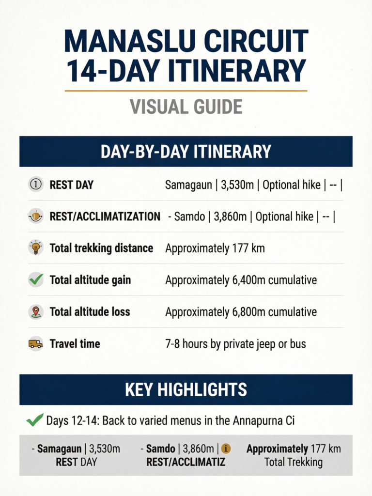
Total trekking distance: Approximately 177 km Total altitude gain: Approximately 6,400m cumulative Total altitude loss: Approximately 6,800m cumulative
Day-by-Day Itinerary
Day 1: Kathmandu to Soti Khola (700m) -- Drive Day
Travel time: 7-8 hours by private jeep or bus Road conditions: Paved to Dhading Besi, then rough dirt road to Arughat and beyond Overnight: Basic lodge in Soti Khola
The trek begins with a long but scenic drive from Kathmandu, heading west through the Prithvi Highway before turning north at Dhading Besi toward the Budhi Gandaki valley. The road is paved until Dhading Besi (about 3 hours), then deteriorates significantly as you approach the trailhead.
The final section from Arughat Bazaar (a large market town where you can buy last-minute supplies) to Soti Khola follows a rough, bumpy road that can take 3-4 hours despite the short distance. During monsoon season or immediately after, this road may be impassable, and alternative starting points may be necessary.
Soti Khola is a small, spread-out settlement along the Budhi Gandaki River. Lodges are basic -- expect simple rooms, shared toilets, and dal bhat for dinner. This is the lowest point of the trek, with a warm, subtropical climate.
What to do on arrival: Rest, check your gear, have an early dinner, and prepare for the first trekking day. The accommodation is basic but adequate.
Pro Tip
Day 2: Soti Khola to Machha Khola (930m)
Trekking time: 6-7 hours Distance: ~14 km Altitude change: +230m net gain (with ups and downs) Terrain: River valley, subtropical forest, suspension bridges
Today you follow the Budhi Gandaki River northward through lush subtropical vegetation. The trail passes through small farming villages, crosses several suspension bridges, and undulates along the river valley. Despite the modest altitude gain, the trail has numerous short climbs and descents that make it more strenuous than the numbers suggest.
Highlights:
- Suspension bridges spanning the turquoise Budhi Gandaki River
- Terraced rice paddies and subtropical vegetation (banana trees, bamboo)
- Waterfalls cascading from the hillsides
- First permit checkpoint at Lapubesi (keep permits accessible)
Machha Khola (meaning "Fish River") is a small village with several basic lodges. You are still in the lowlands here -- expect warm temperatures, possibly insects, and simple accommodation.
Accommodation: Basic lodges with simple rooms and shared facilities. Menus include dal bhat, noodles, and basic Western options.
Day 3: Machha Khola to Jagat (1,340m)
Trekking time: 6-7 hours Distance: ~12 km Altitude change: +410m Terrain: River gorge, forest, some exposed sections
The trail continues up the Budhi Gandaki valley, entering the Manaslu Conservation Area (your MCAP permit is checked at the checkpoint). The valley begins to narrow, and the trail passes through some exposed sections above the river.
Highlights:
- Entry into the Manaslu Conservation Area (permit checkpoint)
- Tatopani hot springs -- Natural hot springs along the trail where you can soak your feet (or whole body). A wonderful trail-side break.
- The narrowing Budhi Gandaki gorge
- Increasing vertical rock walls as the valley deepens
Jagat is a significant checkpoint village with a police post and MCAP checkpoint. Your permits will be thoroughly checked here. This is one of the larger settlements in the lower valley, with several decent lodges.
Accommodation: Improved compared to the first two nights. Basic but clean rooms, good dal bhat, and a friendly atmosphere.
Permit Checkpoint at Jagat
Jagat has a major permit checkpoint where rangers carefully verify your Manaslu Restricted Area Permit, MCAP permit, and TIMS card. Ensure all documents are in order. Your guide typically handles the paperwork, but you should have your passport ready for verification. The process takes 15-30 minutes.
Day 4: Jagat to Deng (1,860m)
Trekking time: 6-7 hours Distance: ~11 km Altitude change: +520m Terrain: Narrow gorge, dramatic cliff trail, waterfalls
This is one of the most dramatic days on the trek. The trail follows the Budhi Gandaki through a spectacular narrow gorge with towering rock walls on either side. In places, the trail is carved into the cliff face, and the river thunders below. You pass through the transition zone between Hindu and Buddhist culture -- the architecture, people, and prayer flags begin to change.
Highlights:
- The spectacular Budhi Gandaki gorge -- vertical rock walls hundreds of meters high
- Cliff-carved trail sections with dramatic exposure
- Cultural transition -- you begin seeing mani walls, prayer flags, and chortens
- Multiple suspension bridges in the gorge
Deng is a small, atmospheric village where Tibetan-Buddhist culture becomes dominant. The village has a few lodges and a monastery. The landscape feels increasingly Himalayan.
Accommodation: Basic but comfortable lodges. The remoteness increases here, and menu options become more limited.
Day 5: Deng to Namrung (2,630m)
Trekking time: 6-7 hours Distance: ~12 km Altitude change: +770m Terrain: Ascending valley, pine and rhododendron forest, Tibetan villages
A significant altitude gain day as you climb from the middle hills into the higher valleys. The landscape transforms dramatically -- subtropical vegetation gives way to pine and rhododendron forests, and the villages are unmistakably Tibetan in character with stone houses, flat roofs, and prayer flags.
Highlights:
- First views of Manaslu (8,163m) and surrounding peaks -- a truly magnificent moment
- Entry into Tibetan Buddhist cultural zone
- Lho village -- stunning Manaslu views and the beautiful Ribung Gompa monastery
- Transition from lowland to highland ecosystem
Namrung is a traditional Tibetan-style village with impressive views. The altitude is now significant (2,630m), and you may begin to notice the thinner air, especially during uphill sections.
Accommodation: Decent lodges with more character than the lower valley options. Heated dining rooms may be available. Tibetan-influenced food begins to appear on menus.
Pro Tip
Day 6: Namrung to Samagaun (3,530m)
Trekking time: 6-7 hours Distance: ~15 km Altitude change: +900m Terrain: Alpine valley, yak pastures, Tibetan villages
A long day with significant altitude gain that brings you to Samagaun, the largest and most important village on the Manaslu Circuit. The trail passes through beautiful Lho village (do not miss the views and the monastery) before ascending into the broader upper valley. You are now firmly in high-altitude territory.
Highlights:
- Lho village -- one of the most photogenic stops on the entire circuit, with Manaslu towering directly behind the village and its monastery
- Stunning panoramic views of Manaslu, Peak 29 (Ngadi Chuli, 7,871m), and surrounding glaciers
- Yak pastures and high-altitude grazing lands
- Arrival in Samagaun -- the cultural heart of the Manaslu region
Samagaun (also spelled Sama) is a large, prosperous village at 3,530m with a strong Tibetan influence. It has the best accommodation and facilities on the circuit -- multiple lodges, a few small shops, a monastery, and a school. This is where you will spend your crucial acclimatization rest day.
Accommodation: The best on the circuit. Some lodges have attached bathrooms, hot showers (solar heated), and heated dining rooms. Menus are relatively varied.
Important: You have gained 900m today and are now at 3,530m. Altitude sickness symptoms may appear. Drink plenty of water, eat well, and report any headaches, nausea, or unusual fatigue to your guide.
Day 7: REST DAY -- Samagaun (3,530m)
Status: Mandatory acclimatization day Activities: Optional day hikes, village exploration Overnight: Same lodge as Day 6
This rest day is not optional -- it is a critical acclimatization day that prepares your body for the push to Larkya La Pass (5,160m) in the coming days. Skipping this rest day dramatically increases your risk of altitude sickness, HAPE, or HACE.
Optional activities:
Option A: Hike to Manaslu Base Camp (4,400m)
- Round trip: 5-6 hours
- Excellent acclimatization hike (climb high, sleep low)
- Spectacular views of Manaslu's north face and the Manaslu Glacier
- Moderate difficulty with some steep sections
Option B: Visit Birendra Lake (3,450m)
- Round trip: 2-3 hours
- A beautiful glacial lake named after the late King Birendra
- Easier option if you are feeling the altitude
- Good views of surrounding peaks
Option C: Explore Samagaun Village
- Visit the Pungyen Gompa (monastery) -- one of the largest in the Manaslu region
- Walk through the village and interact with locals (respectfully)
- Visit the local school
- Observe Tibetan Buddhist culture and daily life
Option D: Pure Rest
- If you are experiencing AMS symptoms (headache, nausea, fatigue), spend the day resting
- Hydrate aggressively (3-4 liters of water)
- Eat regular meals even if appetite is reduced
- Read, journal, or socialize with other trekkers
Do Not Skip This Acclimatization Day
Your guide may feel pressure from tight schedules, and you may feel impatient to keep moving. Resist the temptation. This rest day at 3,530m, combined with a high day hike to Manaslu Base Camp (4,400m), is the key acclimatization event that prepares your body for the pass. Trekkers who skip this day are significantly more likely to develop serious altitude illness.
Day 8: Samagaun to Samdo (3,860m)
Trekking time: 4-5 hours Distance: ~8 km Altitude change: +330m Terrain: High valley, yak pastures, Buddhist culture
A deliberately short day for continued acclimatization. The trail follows the valley north toward the Tibet border, passing through open, windswept terrain with expansive views. You are now in a remote, thinly populated area where the landscape feels vast and austere.
Highlights:
- Vast, open high-altitude landscape
- Views toward the Tibet border
- Samdo village -- the last significant settlement before the pass
- Tibetan cultural immersion (many Samdo residents have Tibetan roots and connections)
Samdo is a small village with a few lodges. It feels remote and wind-exposed, situated at 3,860m in a broad valley. The accommodation is more basic than Samagaun but adequate.
Accommodation: Basic lodges. Rooms may be cold at night. Dining rooms are usually heated. Limited menu options.
Important: Do not push higher today. The short day allows your body to adjust to the increasing altitude. Walk slowly, drink lots of water, and avoid alcohol.
Day 9: Samdo Exploration / Acclimatization Day (3,860m)
Status: Optional but highly recommended rest day Activities: Acclimatization hike toward Tibet border viewpoint Overnight: Same lodge as Day 8
This second acclimatization day is the difference between a comfortable and a dangerous Larkya La crossing. While some itineraries skip this day, we strongly recommend including it, making the total trek 15 days rather than 14.
Optional activities:
Acclimatization Hike: Tibet Border Viewpoint (~4,500m)
- Round trip: 3-4 hours
- Hike north toward the border area for stunning views
- Excellent "climb high, sleep low" acclimatization
- Views of peaks along the Nepal-Tibet border
Village Exploration
- Visit the small monastery in Samdo
- Walk through the village
- Observe yak herding and high-altitude farming practices
Pass Preparation
- Check your gear for the pass crossing
- Ensure headlamp batteries are fresh
- Pack your summit daypack with warm layers, snacks, water, and sunscreen
- Discuss the pass day plan with your guide (start time, weather assessment, emergency protocols)
Pro Tip
Day 10: Samdo to Dharamsala / Larkya Phedi (4,460m)
Trekking time: 4-5 hours Distance: ~7 km Altitude change: +600m Terrain: High valley, glacial moraine, bare terrain
Another short day by design -- you are now entering the danger zone for altitude illness, and the purpose of this day is simply to reach the pass base camp without overexerting yourself.
Highlights:
- Dramatic, barren high-altitude landscape
- Views of Larkya Peak and surrounding glaciers
- Arrival at the most remote accommodation on the entire trek
Dharamsala (also called Larkya Phedi, meaning "foot of the pass") is not a village -- it is a basic stone shelter at 4,460m. Expect:
- Accommodation: A large stone building with dormitory-style sleeping. No private rooms. Basic mattresses on platforms. It will be cold.
- Food: Basic meals prepared by your guide's cook or lodge staff. Hot noodle soup, dal bhat, and tea.
- Water: May be limited. Fill water bottles before arriving.
- Sleep: Difficult at this altitude. Expect restless sleep, possibly headaches. This is normal.
Pass day preparation checklist:
- Headlamp with fresh batteries (start in darkness)
- All warm layers accessible (multiple fleece/down layers, hat, gloves, neck gaiter)
- Sunscreen and sunglasses (high UV above 5,000m)
- 2-3 liters of water in insulated containers (water can freeze)
- High-energy snacks (chocolate, nuts, energy bars)
- Rain/wind jacket and pants
- Trekking poles (essential for the descent)
- Camera (you will want photos at the pass)
Early dinner (4:00-5:00 PM) and early bed (6:00-7:00 PM). Wake up will be around 3:00-4:00 AM.
Altitude Check at Dharamsala
At 4,460m, you are at serious altitude. If any member of your group has significant AMS symptoms (severe headache, persistent vomiting, confusion, breathlessness at rest), they should NOT attempt the pass. Descend to Samdo and reassess. Attempting Larkya La with active altitude sickness is extremely dangerous. See our HAPE and HACE guide for emergency recognition and response.
Day 11: LARKYA LA PASS DAY -- Dharamsala to Bimthang (5,160m → 3,590m)
Trekking time: 8-10 hours Distance: ~18 km Altitude change: +700m ascent, then -1,570m descent Terrain: Glacial moraine, snow/ice (possible), steep descent
This is the biggest day of the trek -- the day everything builds toward. The crossing of Larkya La (5,160m) is physically demanding, logistically complex, and spectacularly beautiful. It requires an early start, stamina, and favorable weather.
Detailed timeline:
3:00-4:00 AM: Wake up. Hot tea and a light breakfast (biscuits, porridge, chapati). Do not eat a heavy meal -- your stomach will not thank you at 5,000m.
4:00-5:00 AM: Depart Dharamsala with headlamps. The trail ascends gradually over glacial moraine in darkness. Walk slowly and steadily.
5:30-6:30 AM: Dawn breaks as you approach the steeper sections. Stunning sunrise over surrounding peaks. The trail becomes steeper and may have snow or ice patches.
7:00-9:00 AM: Reach Larkya La Pass (5,160m). The final approach is steep but not technically difficult. Prayer flags mark the pass summit, and in clear weather, the 360-degree panorama is among the finest in Nepal:
- Manaslu (8,163m) behind you
- Himlung Himal (7,126m) and Cheo Himal (6,820m) ahead
- Annapurna II (7,937m) in the distance
- A sea of peaks stretching to the horizon
Celebrate, take photos, but do not linger. Weather can change rapidly at this altitude, and the long descent awaits.
9:00 AM - 1:00 PM: Descend from the pass. The initial descent is steep and can be treacherous if icy -- trekking poles are essential. The trail drops sharply over loose rock and scree before reaching glacial terrain and eventually the meadows above Bimthang.
1:00-3:00 PM: Arrive in Bimthang (3,590m). A beautiful settlement in a wide valley with jaw-dropping views of Manaslu's south face, Lamjung Himal, and Himlung Himal.
Accommodation in Bimthang: Simple but comfortable lodges. After the Dharamsala experience, even basic rooms with mattresses feel luxurious. Hot food and the relief of having crossed the pass create a celebratory atmosphere.
Pro Tip
What can go wrong on pass day:
- Weather: Snow, wind, and whiteout conditions can make the pass dangerous or impassable. Your guide makes the final decision on whether to attempt the crossing.
- Altitude sickness: If any member of the group develops serious symptoms during the ascent, the entire group may need to turn back. This is why acclimatization days are so critical.
- Trail conditions: Ice and snow on the trail, especially early in the season or after recent snowfall. Crampons or microspikes may be helpful.
- Fatigue: The combination of altitude, cold, and a 10-hour day takes a toll. Pace yourself and eat/drink regularly.
Day 12: Bimthang to Dharapani (1,860m)
Trekking time: 6-7 hours Distance: ~20 km Altitude change: -1,730m Terrain: Forest trails, steep descent, river valley
A long descent day that takes you from the high alpine zone back down into the forested middle hills. The contrast is dramatic -- you start the day surrounded by glaciers and end it in rhododendron forest beside a rushing river.
Highlights:
- Morning views from Bimthang -- Manaslu's south face in morning light
- Descent through rhododendron and pine forest
- Arrival at Dharapani -- the junction with the Annapurna Circuit trail
- The satisfaction of having completed the high-altitude section
Dharapani is a significant village where the Manaslu Circuit trail meets the Annapurna Circuit trail. You will likely see more trekkers here than you have in days. There is a checkpoint where permits may be checked.
Accommodation: Improved facilities compared to the upper circuit. Dharapani caters to both Manaslu and Annapurna Circuit trekkers.
Physical note: The extended downhill can be tough on knees. Use trekking poles, take it slow on steep sections, and consider anti-inflammatory medication if knee pain is an issue.
Day 13: Dharapani to Jagat / Tal (1,700m)
Trekking time: 5-6 hours Distance: ~15 km Altitude change: -160m (relatively flat with ups and downs) Terrain: River valley, villages, easy trail
A relaxed day following the Marsyangdi River valley downstream. The hard work is behind you, and this day is about enjoying the trek's final stages at a comfortable altitude with warm temperatures and lush vegetation.
Highlights:
- Beautiful Marsyangdi River valley scenery
- Waterfalls and terraced farmland
- The village of Tal -- a flat, wide valley floor that feels like an oasis
- Warm temperatures after days of cold at altitude
- A general sense of accomplishment and celebration
Accommodation: Good quality lodges in the Annapurna Circuit corridor. Hot showers, varied menus, and a more comfortable atmosphere.
Day 14: Jagat to Besisahar (760m), then Drive to Kathmandu
Trekking time: 4-5 hours to Besisahar Drive time: 7-8 hours Besisahar to Kathmandu (or 6-7 hours to Pokhara) Altitude change: -940m descent to Besisahar
The final day involves a morning trek to Besisahar (the starting point of the Annapurna Circuit), followed by a long drive back to Kathmandu or onward to Pokhara.
Highlights:
- Final trekking sections through warm, green lowlands
- Arrival in Besisahar -- the symbolic end of the trek
- Cold drinks and celebratory meal
The drive: The road from Besisahar to Kathmandu is paved but winding, taking 7-8 hours. Alternatively, you can drive to Pokhara (6-7 hours) for post-trek relaxation by the lake. See our Pokhara guide and post-trek recovery guide.
Tip for the drive: Book a private jeep or ensure your agency provides comfortable transport. After 14 days of trekking, a cramped local bus for 8 hours is not ideal.
Altitude Profile
Understanding the daily altitude changes helps you prepare mentally and physically:
| Day | Start Altitude | End Altitude | Net Change | Cumulative Max |
|---|---|---|---|---|
| 1 | Kathmandu (1,400m) | Soti Khola (700m) | -700m (drive) | 700m |
| 2 | 700m | 930m | +230m | 930m |
| 3 | 930m | 1,340m | +410m | 1,340m |
| 4 | 1,340m | 1,860m | +520m | 1,860m |
| 5 | 1,860m | 2,630m | +770m | 2,630m |
| 6 | 2,630m | 3,530m | +900m | 3,530m |
| 7 | 3,530m | 3,530m (rest) | 0m | ~4,400m (day hike) |
| 8 | 3,530m | 3,860m | +330m | 3,860m |
| 9 | 3,860m | 3,860m (rest) | 0m | ~4,500m (day hike) |
| 10 | 3,860m | 4,460m | +600m | 4,460m |
| 11 | 4,460m | 3,590m | +700m / -1,570m | 5,160m (Larkya La) |
| 12 | 3,590m | 1,860m | -1,730m | -- |
| 13 | 1,860m | 1,700m | -160m | -- |
| 14 | 1,700m | 760m | -940m | -- |
Where to Add Extra Days
If your schedule allows flexibility, these are the best places to add extra days:
Samdo Rest Day (Day 9) -- Highly Recommended
If you only add one extra day, make it here. The second acclimatization day at 3,860m with a hike to ~4,500m gives your body the best possible preparation for Larkya La. This turns the 14-day itinerary into a 15-day schedule and significantly reduces altitude sickness risk.
Extra Day in Lho (between Days 5-6)
Lho village (3,180m) has spectacular Manaslu views and a beautiful monastery. Adding a night here breaks up the long Day 6 and provides an additional acclimatization step. Turns the itinerary into 16 days.
Extra Day in Bimthang (after Day 11)
If the pass crossing was exhausting and your knees need recovery, an extra day in Bimthang allows rest before the long descent days. The morning views are worth an extra day. Turns the itinerary into 16-17 days.
Acclimatization Strategy
The Manaslu Circuit's acclimatization challenge is significant: you go from 700m (Soti Khola) to 5,160m (Larkya La) in roughly 10 trekking days.
Non-Negotiable Acclimatization Points
-
Samagaun rest day (Day 7): Mandatory. With an acclimatization hike to Manaslu Base Camp (~4,400m), this is your primary adaptation event.
-
Samdo rest day (Day 9): Highly recommended. With an acclimatization hike to ~4,500m, this provides the second "climb high, sleep low" opportunity.
Signs to Watch For
From Day 6 onward, monitor yourself and companions for altitude sickness symptoms:
- Headache (beyond normal tiredness)
- Nausea or loss of appetite
- Dizziness
- Difficulty sleeping
- Unusual fatigue
If symptoms are mild, rest and hydrate. If symptoms worsen, descend. See our altitude sickness prevention guide and HAPE/HACE emergency guide.
Larkya La Pass: Preparation and Tips
The Larkya La crossing is the crux of the Manaslu Circuit. Here is everything you need to know:
Start Time
4:00-5:00 AM departure is standard. This ensures you cross the pass before afternoon weather deterioration. In clear, stable conditions, a 5:00 AM start is fine. If weather is uncertain, 4:00 AM or earlier is better.
What to Carry on Pass Day
Your main bag goes with the porters. In your daypack, carry:
- All warm layers (down jacket, fleece, hat, gloves, neck gaiter)
- Rain/wind jacket and pants
- Sunscreen (SPF 50+) and lip balm with UV protection
- Sunglasses (UV-rated, essential for snow glare)
- 2-3 liters of water (insulated to prevent freezing)
- High-energy snacks for the full day
- Headlamp with fresh batteries
- Camera
- Personal medication (Diamox if taking, painkillers)
- Small first aid supplies
Weather Considerations
- Best months for Larkya La: October-November (autumn) and March-May (spring). See best time for Manaslu.
- Snow and ice: Possible at any time, especially October-November and March-April. Basic crampons or microspikes may be useful.
- Afternoon weather: Clouds, wind, and precipitation typically build after noon. Cross early.
Turnaround Time
If your group has not reached the pass by 11:00 AM and conditions are deteriorating, your guide should seriously consider turning back. Being caught in a whiteout on Larkya La with no shelter is a life-threatening situation.
Emergency Options at Larkya La
- Closest helicopter landing zone: Bimthang (below) or Dharamsala/Samdo (behind)
- No shelter between Dharamsala and Bimthang: Once you leave Dharamsala, the next accommodation is in Bimthang. There is no bailout option partway through the pass crossing.
- Satellite phone: Your guide should carry one for emergencies
Accommodation Expectations by Section
| Section | Days | Quality | What to Expect |
|---|---|---|---|
| Soti Khola to Jagat | 1-3 | Basic | Simple rooms, shared toilets, dal bhat focus, warm temperatures |
| Jagat to Namrung | 4-5 | Basic to moderate | Improving quality, Tibetan character, some heated dining rooms |
| Samagaun | 6-7 | Best on circuit | Some attached bathrooms, hot showers, varied menus |
| Samdo | 8-9 | Basic | Remote village lodges, limited menus, cold at night |
| Dharamsala | 10 | Spartan | Dormitory stone shelter, very basic, cold, limited food |
| Bimthang | 11 | Moderate | Simple lodges, hot food, great views, celebratory atmosphere |
| Dharapani to Besisahar | 12-14 | Good | Annapurna Circuit corridor, better facilities |
Food Availability and Recommendations
- Days 1-5: Dal bhat is the reliable staple. Noodle soups, fried rice, and basic Western options (pancakes, eggs) are usually available.
- Days 6-9: Samagaun has the most varied menus. Samdo is more limited. Stock up on snacks in Samagaun.
- Day 10 (Dharamsala): Very limited. Basic noodle soup, dal bhat, and tea. Bring your own snacks.
- Day 11 (Pass day): No food available on the trail. Carry energy bars, chocolate, nuts, dried fruit.
- Days 12-14: Back to varied menus in the Annapurna Circuit corridor.
Pro Tip
Shorter and Longer Itinerary Options
12-Day Fast Itinerary
For experienced, well-acclimatized trekkers only:
- Combine Days 2-3, skip Samdo rest day
- Higher risk of altitude sickness
- Not recommended for most trekkers
16-Day Comfortable Itinerary
- Add Samdo rest day (Day 9) if not already included
- Add extra day in Lho or Bimthang
- More comfortable pace with better acclimatization
- Recommended for first-time high-altitude trekkers
Combining with Tsum Valley (+5-7 days)
The Tsum Valley is a sacred Himalayan valley that branches off the Manaslu Circuit near Chhekampar. It is a fascinating cultural detour that adds 5-7 days to your trek, visiting ancient monasteries, cave hermitages, and remote Tibetan-Buddhist communities. A separate permit is required for Tsum Valley. The combined Manaslu + Tsum Valley trek takes approximately 20-23 days.
Frequently Asked Questions
How difficult is the Manaslu Circuit compared to EBC or Annapurna Circuit?
The Manaslu Circuit is more strenuous than both Everest Base Camp and the Annapurna Circuit. The lower trail sections involve more cumulative climbing, accommodation is more basic, the route is more remote (fewer escape options), and Larkya La (5,160m) is a demanding pass crossing. Good fitness and previous trekking experience above 4,000m are strongly recommended.
Can I do the Manaslu Circuit independently?
No. The Manaslu region is a restricted area requiring a registered trekking agency, a licensed guide, and a no longer no longer requires a minimum group size (solo trekkers allowed with licensed guide) trekkers. Solo independent trekking is not permitted. See our permits guide.
What is the best time for the Manaslu Circuit?
October-November (autumn) and March-May (spring) are the best seasons. October offers the clearest skies, while spring brings warmer temperatures and rhododendron blooms. See our Manaslu Circuit best time guide.
How much does the Manaslu Circuit cost?
Including permits, agency fees, food, and accommodation, expect $1,200-$2,500 USD depending on your agency and comfort level. See our Manaslu Circuit cost breakdown.
Is there mobile phone coverage on the Manaslu Circuit?
Limited. You may get intermittent Ncell or NTC signal in larger villages (Jagat, Samagaun, Dharapani), but coverage is unreliable. Most lodges in Samagaun offer WiFi (paid, slow). Carry a satellite phone or emergency communication device for safety.
What happens if Larkya La is closed due to weather?
If heavy snow or dangerous conditions close the pass, you have two options: wait in Samdo or Dharamsala for conditions to improve (if your schedule allows), or retrace your steps back down the Budhi Gandaki valley. Your agency should have contingency plans for this scenario. This is more common in late November, December, and early spring.
Can I hire porters for the Manaslu Circuit?
Yes, and it is highly recommended. Your agency will typically arrange porters as part of the package. The lower sections involve significant daily walking, and carrying a heavy pack adds unnecessary fatigue. A porter carries 20-30 kg and typically costs $20-25 USD per day.
Is the Manaslu Circuit crowded?
No. Compared to EBC and ABC, the Manaslu Circuit sees far fewer trekkers due to the restricted area permit requirement and higher cost. Even during peak season (October), you may see only 10-30 trekkers per day at most. This is one of the trek's greatest appeals.
Do I need crampons for Larkya La?
Not usually, but microspikes or basic crampons can be helpful if there is snow or ice on the pass. Check with your agency about conditions and whether they provide them. In mid-October through November and March through April, snow is possible.
What vaccinations or medications should I have?
Consult a travel medicine clinic 4-6 weeks before your trip. Standard recommendations include: Hepatitis A and B, Typhoid, Tetanus booster, and Diamox (Acetazolamide) for altitude sickness prevention. See our first aid medical kit guide.
What is the minimum fitness level needed?
You should be able to walk 6-8 hours per day on hilly terrain for consecutive days. Regular cardiovascular exercise (running, cycling, hiking) for at least 3 months before the trek is recommended. Previous trekking experience above 4,000m is beneficial. See our fitness requirements guide.
Final Thoughts
The Manaslu Circuit is a trek that rewards patience, preparation, and respect for the mountains. The 14-day itinerary outlined here provides a well-paced schedule with proper acclimatization, though adding a 15th day (extra rest in Samdo) makes it even safer and more enjoyable.
The highlights are unforgettable: the dramatic Budhi Gandaki gorge, the cultural richness of Samagaun, the raw challenge of Larkya La, and the profound remoteness of a route that still feels like genuine adventure rather than a tourist highway.
For agency recommendations, see our guide to the best trekking agencies for Manaslu Circuit. For what to pack, see our Nepal trekking packing list. And for post-trek recovery after this demanding circuit, see our post-trek recovery guide.