

| Route | Duration | Max Altitude | Difficulty | Permits | Teahouses | Crowds |
|---|---|---|---|---|---|---|
| Ama Dablam Base Camp | 10-12 days | 4,570m | Moderate-Challenging | $50-55 | Good | Low |
| Everest Base Camp (Kala Patthar) | 12-16 days | 5,545m | Moderate-Challenging | $50-55 | Excellent | Very High |
| Gokyo Lakes | 12-15 days | 5,357m | Moderate-Challenging | $50-55 | Excellent | Moderate |
| Island Peak Base Camp | 12-14 days | 5,100m | Challenging | $50-55+ | Good | Moderate |
Ama Dablam has been called the most beautiful mountain in the world. At 6,812 meters, it doesn't rival Everest in height, but in form — the sweeping ridges, the dramatic hanging glacier, the steep symmetry that rises above the Khumbu Valley like a cathedral — it surpasses every peak in the range for sheer elegance. Climbers and photographers have agreed on this for decades.
The Ama Dablam Base Camp trek brings you to within close proximity of this spectacular mountain — no climbing required, no technical gear, just a 10-12 day trekking journey through the heart of the Khumbu to the expedition base camp at 4,570 meters. This is the Everest region at its most quietly dramatic: the classic Sherpa villages, the high-altitude monasteries, the glaciated valleys — with Ama Dablam as your constant, compelling companion.
Unlike the Everest Base Camp route that channels thousands of trekkers through the same corridor each season, the Ama Dablam Base Camp approach branches off at Pangboche, where most EBC-bound trekkers continue north. You'll find the trail quieter, the lodges less crowded, and the mountain more intimate.
This guide covers everything: detailed itinerary, acclimatization strategy, comparison with EBC, and all the logistical details for planning your journey to the base of Nepal's most beautiful peak.
Route Snapshot
10-12 days from Lukla
4,570m (14,993 ft) at Ama Dablam Base Camp
80-95 km (50-59 miles)
Moderate to Challenging
Mar-May (Spring), Oct-Nov (Autumn)
Khumbu, Everest Region
Lukla (via Kathmandu flight)
Sagarmatha National Park ($30), TIMS (NPR 2,000)
Teahouse lodges throughout
$1,200-$2,500 (all-inclusive)
Popular Route Variants:
| Variant | Duration | Highlights | Best For |
|---|---|---|---|
| Standard Base Camp | 10-11 days | Namche, Tengboche, Pangboche, ADBC | Most trekkers |
| Extended Acclimatization | 12-14 days | Extra rest days at Namche and Pangboche | First-time high-altitude trekkers |
| ADBC + EBC Combo | 18-22 days | Both base camps via Lobuche | Maximum Everest region experience |
| ADBC + Gokyo | 16-18 days | Base camp then Gokyo Lakes loop | Experienced trekkers |
Ama Dablam: The Himalayan Matterhorn
Ama Dablam (6,812m) towers over the Khumbu Valley with an authority that goes beyond its relatively modest height among Himalayan giants. The name translates from Tibetan as "Mother's Necklace" — a reference to the hanging glacier on the southwest ridge that resembles a pendant worn by a Sherpa mother.
Why Ama Dablam Is Special
The mountain's unique qualities:
Ama Dablam rises from the valley floor with a steepness that makes it appear far taller than its 6,812 meters. From Namche Bazaar, Tengboche, or Pangboche, it dominates the skyline — not because it's the highest peak visible, but because its proportions are so perfectly dramatic.
Unlike Everest, which retreats behind foothills and only reveals itself when you're well into the approach, Ama Dablam announces itself from Namche onward and accompanies you for the remainder of the trek. Photographers who visit the Khumbu specifically to photograph mountains almost always cite Ama Dablam as the most photogenic subject.
Climbing history: The first ascent came in 1961, by a New Zealand-American expedition that included Sir Edmund Hillary's companions. The standard route — the southwest ridge — is considered one of the most beautiful technical climbs in the world. During October-November expedition season, you'll see high camp tents clinging to the ridge above you when you stand at base camp.
The Base Camp Experience
Reaching base camp at 4,570 meters places you at the foot of the southwest ridge, the primary ascent route. The base camp sits on a moraine terrace with unobstructed views of the entire southwest face — a vertical wall of rock and ice that ascends nearly 2,400 meters above you.
What you'll see and experience at base camp:
- The south face: The full sweep of the southwest ridge and main face
- Expedition infrastructure (during season): Colorful tents, fixed ropes visible on the lower ridge, the organized activity of a climbing expedition
- Glacier scenery: The Ama Dablam Glacier moraine and surrounding high terrain
- Panoramic views: Makalu, Baruntse, and the Khumbu peaks surrounding the base camp plateau
Expedition Season Overlap
Ama Dablam expeditions are typically active during October-November (autumn season) and to a lesser extent spring. Trekking to base camp during these periods means you may encounter actual expedition teams preparing for summit attempts. Climbing teams are generally welcoming of respectful trekker visitors — this adds a unique dimension unavailable on the EBC route where base camp is often empty of active climbers.
Route Overview: Lukla to Ama Dablam Base Camp
The Classic Approach
The Ama Dablam Base Camp route follows the main EBC highway from Lukla to Pangboche, then branches east to the base camp. This means you experience all the classic Khumbu highlights — Namche Bazaar, Tengboche Monastery, Dingboche — before reaching your specific objective.
Day 1: Kathmandu → Lukla (2,840m) → Phakding (2,610m)
Day 2: Phakding → Namche Bazaar (3,440m)
Day 3: Namche Bazaar acclimatization day
Day 4: Namche → Tengboche (3,860m)
Day 5: Tengboche → Pangboche (3,985m)
Day 6: Pangboche → Ama Dablam Base Camp (4,570m) and back to Pangboche
Day 7: Pangboche rest or Dingboche (4,410m) side trip
Day 8: Pangboche → Namche Bazaar
Day 9: Namche → Lukla (2,840m)
Day 10: Lukla → Kathmandu
Trail Terrain Summary
| Section | Distance | Elevation Change | Terrain | Challenge |
|---|---|---|---|---|
| Lukla to Namche | 20-22 km | +830m net | Valley trail, suspension bridges | Moderate |
| Namche to Tengboche | 10-12 km | +420m net | Ridge trail, forest | Moderate |
| Tengboche to Pangboche | 5-6 km | +125m | Rhododendron forest, open valley | Easy-Moderate |
| Pangboche to ADBC | 6-8 km | +585m | Moraine trail, open slopes | Moderate-Challenging |
| Return to Lukla | 35-38 km | -1,730m net | Descent over 3 days | Moderate (knees) |
Complete Itinerary: 10-Day Trek
Day 1: Kathmandu to Lukla to Phakding (2,610m)
Flight: Kathmandu to Lukla (~30 minutes) Trek: Lukla to Phakding (2-3 hours) Elevation change: -230m
The famous Tenzing-Hillary Airport at Lukla receives your aircraft at 2,840 meters — altitude that begins working on your physiology immediately. After sorting gear at the airport, your trek begins immediately along the Dudh Koshi river valley, descending gently to Phakding for the first night.
The trail is well-worn, the scenery spectacular from the first steps: suspension bridges, river gorges, rhododendron and pine forest, and glimpses of high peaks ahead. The afternoon walk to Phakding takes the edge off travel-day restlessness.
Day 2: Phakding to Namche Bazaar (3,440m)
Trek duration: 5-6 hours Elevation gain: +830m (with several dips)
This classic stage climbs from the valley floor to the famous trading hub of Namche Bazaar, the capital of Khumbu trekking. The route crosses the Dudh Koshi river multiple times on iconic suspension bridges — some of the highest in the world — before the long final climb to Namche.
The first views of Ama Dablam appear as you crest the final ridge above Namche. The mountain materializes above the valley head with startling drama — your first sight of your objective.
Namche Bazaar highlights:
- Saturday market (traditional Sherpa-Tibetan trading)
- Trekking shops and equipment rental
- The Hillary school and Sherpa culture museum
- First clear Ama Dablam views from the ridge above town
Day 3: Namche Bazaar Acclimatization Day (3,440m)
Day hike: Khumjung or Everest View Hotel (3,880m) Elevation gain for day hike: +440m
The golden rule of Khumbu trekking: spend two nights in Namche. Your body needs time at this altitude before continuing higher. The day is not wasted — Namche rewards exploration.
Acclimatization hike options:
- Everest View Hotel (3,880m): A 2-3 hour uphill walk to a viewpoint with possibly the most famous mountain view accessible at altitude
- Khumjung village: Traditional Sherpa village above Namche, home to the Hillary school and the alleged yeti scalp in the monastery
- Syangboche Airstrip: Short uphill for views over Namche and toward Ama Dablam
The key principle: hike high, sleep low. Climb 300-500 meters above your sleeping altitude during the day, return to Namche to sleep.
Information current as of January 2025.
Namche Bazaar
3,440m
Room: $15-30/night
Dal Bhat: $8-15
Last ATM before the mountains. Stock up on cash, snacks, and any gear you're missing. Two nights minimum for acclimatization — this is not optional.
Day 4: Namche to Tengboche (3,860m)
Trek duration: 4-5 hours Distance: 10-12 km Elevation gain: +420m net
This beautiful stage climbs from Namche on a contour trail with continuous mountain views before descending to cross the Dudh Koshi and climbing again to the Tengboche ridge. Ama Dablam is your constant companion now — visible for most of the walk, growing closer and more detailed with each kilometer.
Tengboche Monastery, sitting on a ridge above the treeline with Ama Dablam directly behind it, is one of Nepal's most photographed scenes. The large monastery (the most important in the Khumbu) offers afternoon prayer sessions that visitors are welcome to observe.
Tengboche highlights:
- Tengboche Monastery — attend afternoon prayers if timing allows
- Highest-elevation rhododendron forest in the Himalayas
- Panorama of Everest, Lhotse, Nuptse, and Ama Dablam from the ridge
- The famous "Ama Dablam behind the monastery" photograph location
Photography Tip: Tengboche at Dawn
The classic photograph of Tengboche Monastery with Ama Dablam rising behind it is best captured at dawn when alpenglow catches the peak. Set an alarm and walk to the monastery in the dark — you'll likely be alone, and the light is worth it.
Day 5: Tengboche to Pangboche (3,985m)
Trek duration: 3-4 hours Distance: 5-6 km Elevation gain: +125m net
A shorter day that descends through magnificent rhododendron forest before climbing gently to Pangboche — the highest permanently inhabited village in the Khumbu, and your base for the Ama Dablam Base Camp excursion.
Pangboche has two sections: Lower Pangboche (3,985m) and Upper Pangboche (4,050m), each with lodges. The older upper village is more traditional, with the Pangboche Monastery — possibly the oldest in Khumbu — at its center.
Pangboche Monastery: This ancient gompa houses relics including what is claimed to be a yeti scalp and hand, drawing curious visitors for decades. The monastery dates to the 17th century and remains an active place of worship. Morning prayers are conducted daily.
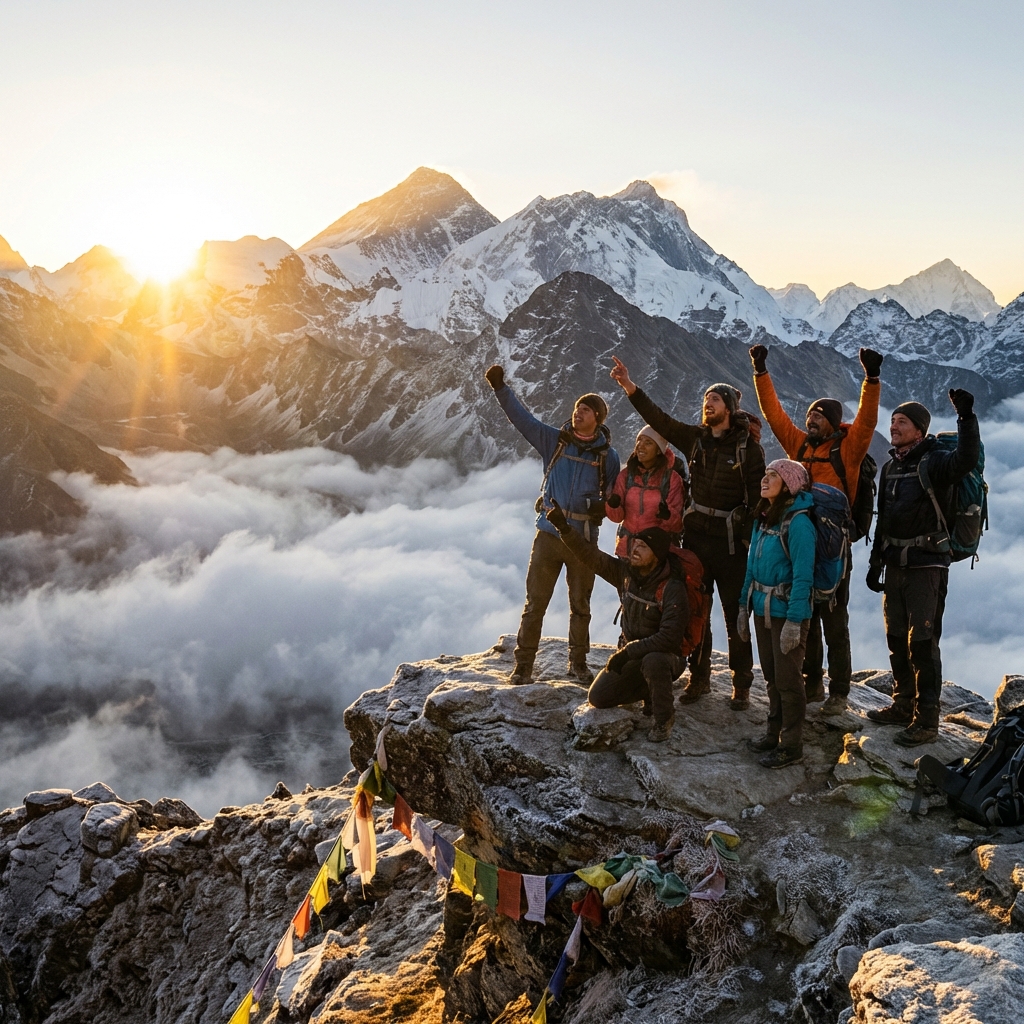
Day 6: Pangboche to Ama Dablam Base Camp (4,570m) and Return
Trek duration: 3-4 hours up, 2.5-3 hours down Distance: 12-14 km round trip Elevation gain: +585m
The goal day. From Pangboche, the trail climbs through open yak pastures and rocky moraine terrain to reach the base camp plateau below Ama Dablam's southwest face. The approach offers continuously improving views of the mountain's full profile.
The approach trail:
- Leave Pangboche by 7:00-8:00 AM
- First section through upper yak grazing pastures
- Trail becomes rockier and more exposed above 4,000m
- Final push up moraine to base camp plateau at 4,570m
At base camp:
The base camp area sits on a broad moraine shelf with unobstructed views of the southwest face. The mountain rises above you with vertiginous drama — from this angle you can see the full technical route including the famous Dablam (the hanging glacier), the Yellow Tower, and the upper ridges where summit camps are established.
During expedition season, you may share the base camp with actual climbing teams. These encounters — respectful and curious on both sides — add dimension to the experience that simply doesn't happen at Everest Base Camp, which is often empty of active climbers.
Return to Pangboche:
Descend by early afternoon, aiming to be back at Pangboche lodges by 2:00-3:00 PM. The descent rewards backward glances as the mountain's profile changes with every step downhill.
Information current as of January 2025.
Pangboche
3,985m
Room: $12-20/night
Dal Bhat: $7-10
Excellent base for Ama Dablam Base Camp day. The upper village monastery is worth a morning visit before your base camp push.
Ama Dablam Base Camp
4,570m
Room: N/A (day visit only for trekkers)
Dal Bhat: N/A
Carry packed lunch and plenty of warm layers. Wind can be significant. Arrive before noon for best light on the face.
Days 7-10: Return to Lukla and Kathmandu
Day 7: Pangboche rest day or optional Dingboche (4,410m) side trip Day 8: Pangboche to Namche Bazaar (4-5 hours) Day 9: Namche to Lukla (5-6 hours) Day 10: Lukla to Kathmandu flight
The return follows the same trail downward, though descending the same path feels entirely different — faster, easier, and offering forward views into valleys that were behind you on the way up. Many trekkers use the return days for photography they missed on the approach.
Difficulty Assessment
Moderate to ChallengingWhat makes this trek challenging:
- Altitude: Maximum 4,570m at base camp; sleeping above 3,800m for multiple nights
- Duration: 10-12 days of sustained trekking at altitude
- Cumulative fatigue: Consecutive days above 3,500m require proper acclimatization
- Lukla approach: The famous Lukla flight (and potential delays) adds logistical stress
What makes it achievable for fit trekkers:
- Standard trail: No technical terrain, well-maintained paths
- Good teahouse infrastructure: Reliable lodges throughout
- Guided route: Well-signposted with regular guide services available
- Bail-out options: Can descend quickly if altitude issues arise
Fitness requirements:
- Walk 5-7 hours consecutively on uneven terrain
- Sustained uphill climbing at altitude (above 3,500m)
- 10+ consecutive days of trekking
- Previous hiking experience strongly recommended; altitude experience helpful
Acclimatization Strategy
Proper acclimatization is the critical factor for a successful Ama Dablam Base Camp trek.
The Golden Rules:
- Two nights in Namche (3,440m) minimum — non-negotiable
- Hike high, sleep low on acclimatization day
- Ascend no more than 300-500m per sleeping altitude after 3,000m
- If headache or nausea persists, descend — never ascend with symptoms
- Stay well hydrated (3-4 liters per day at altitude)
- Avoid alcohol for the first 3-4 days at altitude
AMS Symptom Recognition:
- Mild: Headache, nausea, fatigue — rest, hydrate, do not ascend
- Moderate: Severe headache unresponsive to ibuprofen, vomiting — descend immediately
- Severe: Confusion, loss of coordination, wet cough — emergency descent, helicopter if needed
Best Time to Visit
| Month | High | Low | Conditions | Crowds | Notes |
|---|---|---|---|---|---|
| January | 4°C | -12°C | 10mm | Very Low | Extreme cold. Some lodges closed. Only for very experienced winter trekkers. |
| February | 6°C | -10°C | 20mm | Very Low | Cold but clearing. Some early-season trekkers begin. |
| MarchBest | 10°C | -6°C | 35mm | Low-Moderate | Spring begins. Good visibility. Rhododendrons blooming lower down. Pre-season quiet. |
| AprilBest | 14°C | -2°C | 50mm | Moderate-High | Peak spring season. Good weather, full services, climbing expeditions active. Excellent. |
| MayBest | 16°C | 0°C | 80mm | Moderate | Late spring. Some afternoon clouds. Pre-monsoon building. Still generally good. |
| June | 16°C | 4°C | 180mm | Very Low | Monsoon arriving. Poor visibility. Not recommended. |
| July | 16°C | 6°C | 260mm | Very Low | Full monsoon. Avoid. |
| August | 15°C | 6°C | 250mm | Very Low | Monsoon continues. |
| September | 14°C | 2°C | 130mm | Low | Monsoon clearing late month. Some trekkers begin. Variable conditions. |
| OctoberBest | 10°C | -5°C | 25mm | Very High | Best overall conditions. Crystal clear skies. Ama Dablam climbing expeditions active. Busy but stunning. |
| NovemberBest | 6°C | -8°C | 10mm | Moderate-High | Excellent clarity. Cooler temperatures. Fewer trekkers than October. Very good month. |
| December | 3°C | -12°C | 5mm | Low | Cold. Short days. Some lodges closing. For experienced cold-weather trekkers only. |
Best months: October and April offer the ideal combination of clear skies, comfortable temperatures (by high-altitude standards), and active expedition atmosphere.
Permits and Costs
Required Permits
| Permit | Cost (USD) | Notes |
|---|---|---|
| Sagarmatha National Park | $30 | Paid at the checkpoint before Namche |
| TIMS Card | NPR 2,000 (as of 2026) | Obtained in Kathmandu or Lukla |
Cost Breakdown
| Package Type | Price Range (USD) | Includes |
|---|---|---|
| Budget Group | $1,200-$1,600 | Basic lodges, shared guide, most meals, Lukla flight |
| Standard Private | $1,600-$2,000 | Good lodges, private guide + porter, all meals, Lukla flight |
| Comfortable Private | $2,000-$2,500 | Best lodges, experienced guide, all services, Lukla flight |
Fixed Costs:
- Kathmandu-Lukla round trip flight: $215-320 per person
- National Park permit: $30
- Licensed guide: $35-40/day
- Porter (optional): $25-30/day
Frequently Asked Questions
How does this compare to the Everest Base Camp trek?
The ADBC trek is 2-4 days shorter and reaches a lower maximum altitude (4,570m vs 5,545m at Kala Patthar), making it moderately less physically demanding. The trail follows the same EBC route until Pangboche. The key difference is your destination: Ama Dablam Base Camp offers closer views of a more photogenic mountain with dramatically fewer crowds than Everest Base Camp.
Do I need altitude experience?
Previous experience above 3,500m is helpful but not strictly required with proper acclimatization scheduling. The 10-12 day itinerary builds altitude gradually. However, trekkers who have never experienced altitude should add 1-2 extra acclimatization days.
Can I see Everest from this trek?
Yes. Everest is visible from multiple points on the route — from the ridge above Namche, from Tengboche, and from the upper approaches to Ama Dablam Base Camp. You won't be as close as on the EBC route, but Everest features prominently in the panorama throughout.
Is the Lukla flight reliable?
Lukla flights are weather-dependent and cancellations are common, particularly in the shoulder seasons. Always build 1-2 buffer days in Kathmandu for delayed return flights. Travel insurance with trip delay coverage is essential.
What's the difference between spring and autumn for this trek?
Autumn (October-November) offers the clearest skies and most stable weather, coinciding with Ama Dablam climbing expedition season. Spring (March-May) has slightly more cloud potential but features rhododendron blooms on the lower trail. Both are excellent; autumn has marginally better mountain views.
Related Routes and Planning Resources
Nearby Treks in Everest Region:
- Everest Base Camp Trek — The classic ultimate objective
- Gokyo Lakes Trek — Alternative Everest viewpoint with turquoise lakes
- Namche to Thame Loop — Short cultural loop from Namche
- Everest Three Passes Trek — Advanced full circuit
Essential Planning Guides:
- Everest/Khumbu Region Overview — Complete Khumbu planning guide
- Nepal Trekking Permits Explained — Permit details
- Altitude Sickness Prevention — Critical safety guide
- Best Time to Trek Everest Region — Seasonal advice
Final Thoughts: Beauty Over Fame
Everest is the world's tallest mountain. Ama Dablam may be the world's most beautiful. These are not competing claims — they measure different things. And the fact that far fewer trekkers make the journey to Ama Dablam's base camp, despite it being shorter and lower than EBC, means you get to experience a Khumbu that feels closer to what it was before mass trekking tourism.
Standing below Ama Dablam's southwest face, watching its ridges catch morning light while expedition tents dot the moraine around you, you understand why climbers call this the most aesthetic objective in the Himalayas. The mountain has a presence that statistics cannot capture.
Come for the mountain. Stay for the journey through the Khumbu that gets you there.
This guide is maintained by the Nepal Trekking Team with input from Khumbu-based guides, the Ama Dablam expedition community, and verified trekking data. Last updated March 2026.


