Skip to content
+977-9861293812
WhatsApp
Trek and Tour Nepal
Annapurna Region · Nepal

Annapurna Circuit Trek

Guaranteed departure4.8from 276 reviews
Days
16
Highest point
5,416 m
Level
Challenging
Best months
Mar to May and Sep to Nov

Overview

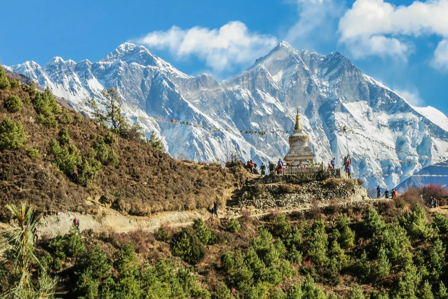
There are few treks on Earth that can match the sheer variety of the Annapurna Circuit. Over 16 unforgettable days, you walk through a living atlas of Nepal — from steamy subtropical river valleys thick with banana groves and rice paddies, through ancient Gurung and Thakali villages where prayer wheels spin in the breeze, up into alpine meadows ablaze with wildflowers, and finally into the stark, windswept desert of the Manang Valley that feels more Tibetan plateau than Himalayan foothills. The climax is the crossing of Thorong La Pass at 5,416m, one of the highest trekking passes in the world, rewarding you with a sunrise panorama that stretches from Dhaulagiri to the Annapurna massif. The descent into the sacred town of Muktinath and the world's deepest gorge of the Kali Gandaki completes a journey of extraordinary contrasts. This trek is ideal for experienced trekkers seeking a longer immersive adventure through Nepal's most diverse landscapes. Spring (March-May) brings rhododendron blooms and clear skies, while autumn (October-November) offers the most stable weather and the sharpest mountain views. No other single trek delivers this breadth of culture, geography, and high-altitude drama.

Want more detail on this route?

Read our full route guide with trail conditions, permits, and planning tips.

Route Guide

Highlights

Cross Thorong La Pass at 5,416m, one of the world's highest trekking passes
Trek through the Kali Gandaki, the deepest gorge on Earth
Visit the sacred pilgrimage temple of Muktinath with its 108 water spouts
Experience landscapes spanning subtropical jungle to arid Tibetan-style desert
Stay in authentic Gurung and Thakali villages along the ancient trade route

Itinerary

16 days
Highest stop
4,450 m
Day 11
Biggest climb
+750 m
Day 5
Over 2,500 m
8 days
of 16

Day 1 of 16 · Arrival in Kathmandu

1,400 m

2,500 m · altitude zone
  1. Day 1

    Arrival in Kathmandu

    • 1,400 m
    • Hotel
    • Dinner

    Your Annapurna Circuit adventure begins at Tribhuvan International Airport in Kathmandu (1,400m). Our airport representative meets you outside the arrivals hall and transfers you to your hotel in the Thamel district, approximately 8 km from the airport. In the evening, attend a comprehensive trek briefing at the hotel where your guide reviews the 16-day itinerary, checks your gear, and issues any last-minute packing recommendations.

  2. Day 2

    Drive to Besisahar, Trek to Khudi

    • 790 m
    • Down610 m from day 1
    • Teahouse
    • Breakfast, Lunch, Dinner

    Depart Kathmandu early morning for the 6-7 hour drive west along the Prithvi Highway to Besisahar (760m), the district headquarters of Lamjung and the traditional starting point of the Annapurna Circuit. The road follows the Trisuli River through terraced hillsides and roadside settlements. From Besisahar, begin trekking north along the Marsyangdi River valley approximately 5 km to the village of Khudi (790m), a gentle 2-hour warm-up walk on a flat trail.

    See Besisahar on the map
  3. Day 3

    Trek to Bahundanda

    • 1,310 m
    • Up520 m from day 2
    • Teahouse
    • Breakfast, Lunch, Dinner

    Today's trek covers approximately 12 km over 5-6 hours, ascending from Khudi (790m) to Bahundanda (1,310m) with a total elevation gain of 520m. The trail follows the eastern bank of the Marsyangdi River, passing through the villages of Bhulbhule and Ngadi before a final steep climb to Bahundanda, whose name means 'Brahmin hill' — a settlement perched dramatically on a ridge above the valley.

  4. Day 4

    Trek to Chamje

    • 1,410 m
    • Up100 m from day 3
    • Teahouse
    • Breakfast, Lunch, Dinner

    The trail from Bahundanda to Chamje covers approximately 10 km over 5-6 hours with modest elevation gain, as you descend from the ridge at 1,310m before climbing gently to Chamje at 1,410m. The route features several dramatic suspension bridges over the Marsyangdi River, some swaying 30-40 metres above the churning whitewater below. The gorge narrows significantly as the river carves deeper into the bedrock, and you walk along narrow cliff-edge trails with steel cables for handrails.

    See Chamje on the map
  5. Day 5

    Trek to Bagarchap

    • 2,160 m
    • Up750 m from day 4
    • Teahouse
    • Breakfast, Lunch, Dinner
    • Biggest climb

    Today's trek of approximately 12 km over 6-7 hours ascends from Chamje (1,410m) to Bagarchap (2,160m), gaining 750m in elevation — the most significant altitude gain so far. The trail passes through Tal (1,700m), a flat village on an ancient lakebed, and continues upward through increasingly dramatic terrain. You officially enter the Manang District today, crossing a cultural boundary from Hindu lowland villages into Buddhist highland settlements.

    See Bagarchhap on the map
  6. Day 6

    Trek to Chame

    • 2,670 m
    • Up510 m from day 5
    • Teahouse
    • Breakfast, Lunch, Dinner

    The trek from Bagarchap to Chame covers approximately 11 km over 5-6 hours, gaining 510m as you ascend from 2,160m to 2,670m. The trail passes through Danaque and Koto — the latter being the checkpoint for the restricted Nar Phu Valley — before continuing through blue pine forest to Chame, the administrative capital of Manang District. The Marsyangdi River remains your constant companion, and the trail crosses it several times on well-built bridges.

    See Chame on the map
  7. Day 7

    Trek to Pisang

    • 3,200 m
    • Up530 m from day 6
    • Teahouse
    • Breakfast, Lunch, Dinner

    Today's 15 km trek from Chame (2,670m) to Pisang (3,200m) takes approximately 5-6 hours, gaining 530m through a landscape that shifts from dense pine forest to open alpine terrain. The trail passes through Bratang with its famous apple orchards and a dramatic narrowing of the valley where rockfall debris has created a natural gateway. Beyond this point, the vegetation thins and you enter the Manang Valley — a broad, arid rain shadow valley that feels more Tibetan plateau than Himalayan forest.

    See Pisang on the map
  8. Day 8

    Trek to Manang

    • 3,540 m
    • Up340 m from day 7
    • Teahouse
    • Breakfast, Lunch, Dinner

    The trek from Pisang to Manang covers approximately 18 km over 6-7 hours, but the elevation gain is modest — only 340m from 3,200m to 3,540m — making it an excellent acclimatization day with more lateral distance than vertical gain. The trail passes through Hongde (with its small airstrip), the medieval village of Braga, and several stretches of open alpine meadow before reaching Manang village.

    See Manang on the map
  9. Day 9

    Acclimatization Day in Manang

    • 3,540 m
    • Teahouse
    • Breakfast, Lunch, Dinner
    • Acclimatization

    This rest day in Manang (3,540m) is critical for safe acclimatization before ascending toward Thorong La Pass. The recommended acclimatization hike is to Gangapurna Lake (3,580m), a 30-minute walk from the village to a glacial lake at the base of the Gangapurna icefall, or the more ambitious climb to Ice Lake (Kicho Tal) at 4,600m — a challenging 4-5 hour round trip that gains over 1,000m and delivers stunning panoramic views of the Annapurna, Gangapurna, and Chulu ranges.

    See Manang on the map
  10. Day 10

    Trek to Yak Kharka

    • 4,110 m
    • Up570 m from day 9
    • Teahouse
    • Breakfast, Lunch, Dinner

    Departing Manang, today's trek covers approximately 9 km over 4-5 hours, ascending from 3,540m to Yak Kharka at 4,110m — a gain of 570m through increasingly barren and windswept terrain. The trail passes through Tenki Manang and Gunsang, small settlements with basic teahouses, before reaching the yak pastures that give Yak Kharka its name. The Marsyangdi Valley widens here into a high-altitude steppe dotted with grazing yaks and stone corrals.

    See Yak Kharka on the map
  11. Day 11

    Trek to Thorong Phedi

    • 4,450 m
    • Up340 m from day 10
    • Teahouse
    • Breakfast, Lunch, Dinner
    • Highest stop

    A short but significant day: approximately 5 km over 3-4 hours, ascending from Yak Kharka (4,110m) to Thorong Phedi (4,450m), gaining 340m. The trail climbs steadily along the barren valley floor, crossing glacial streams on simple log bridges. Thorong Phedi — meaning 'foot of Thorong' — is the base camp for the pass crossing. It sits in a narrow valley at the base of the steep moraine wall that leads up to Thorong La.

  12. Day 12

    Cross Thorong La Pass, Descend to Muktinath

    • 3,800 m
    • Down650 m from day 11
    • Teahouse
    • Breakfast, Lunch, Dinner

    The defining day of the Annapurna Circuit. Depart Thorong Phedi at 4:00 AM by headlamp, ascending 966m over approximately 5 km to reach Thorong La Pass (5,416m) — the highest point of the trek. The climb takes 4-5 hours on a steep, switchbacking trail through loose moraine and scree. From the pass, descend 1,616m over approximately 9 km in 3-4 hours down a steep trail to the sacred town of Muktinath (3,800m). Total walking time is 8-10 hours.

    See Muktinath on the map
  13. Day 13

    Trek to Jomsom

    • 2,720 m
    • Down1,080 m from day 12
    • Teahouse
    • Breakfast, Lunch, Dinner

    A gentle and scenic descent of approximately 20 km over 5-6 hours from Muktinath (3,800m) to Jomsom (2,720m) through the legendary Kali Gandaki gorge — the deepest river valley in the world, flanked by Dhaulagiri (8,167m) to the west and Annapurna I (8,091m) to the east. The trail passes through Kagbeni, a medieval walled town at the gateway to Upper Mustang, and continues south along the wide, wind-scoured riverbed to Jomsom.

    See Jomsom on the map
  14. Day 14

    Fly to Pokhara

    • 820 m
    • Down1,900 m from day 13
    • Hotel
    • Breakfast

    Take the spectacular 20-minute morning flight from Jomsom (2,720m) to Pokhara (820m), one of the most scenic short flights in the world. The Twin Otter aircraft threads through the Kali Gandaki gorge with Dhaulagiri and Annapurna towering on either side — have your camera ready for aerial views that rival anything seen from the trail. Flights depart early morning when winds are calm; afternoon flights are frequently cancelled due to the valley's notorious gusts.

  15. Day 15

    Drive or Fly to Kathmandu

    • 1,400 m
    • Up580 m from day 14
    • Hotel
    • Breakfast

    Travel from Pokhara (820m) back to Kathmandu (1,400m), either by a 25-minute domestic flight offering spectacular views of the Himalayan range, or by a 6-7 hour drive along the Prithvi Highway following the Trisuli and Marsyangdi rivers through the middle hills. The drive passes through Kurintar and Mugling — good rest stops with riverside restaurants — and climbs over the final ridge before descending into the Kathmandu Valley.

  16. Day 16

    Departure

    • 1,400 m
    • Breakfast

    Your Annapurna Circuit adventure concludes today. Transfer from your hotel to Tribhuvan International Airport for your international departure flight. The drive takes approximately 30-45 minutes depending on traffic, so allow at least 3 hours before your scheduled departure. Your guide or a company representative accompanies you to the airport terminal.

Want a different pace?

A local guide can add a rest day, shorten a stage, or swap where you sleep. We reply within 24 hours.

Ask a guide on WhatsApp

What's Included

Best Time to Trek Annapurna Circuit

Month by month

Main seasons: Mar to May and Sep to Nov

Tap a month to add it to your plan.

Spring

Rhododendron forests between Chamje and Upper Pisang explode with color in March-April. Thorong La crossing conditions are stable, with snowmelt opening the pass reliably by mid-March.

Autumn

October-November delivers the sharpest mountain views and the most stable weather for the 5,416m Thorong La crossing. Teahouses are busier but the atmosphere is festive — Dashain and Tihar celebrations add cultural depth.

From
$1,099/ person

Before you book

Is the Annapurna Circuit Trek right for you?

Straight answers from this trek's own plan. Tap Ask about this on anything you are unsure of, and we send it all to a local guide in one message.

Who this trek suits

Designed for experienced trekkers who want Nepal's most diverse landscape in a single route. Autumn delivers the sharpest views for the Thorong La crossing, spring wraps the lower valleys in wildflower color, and the 16-day duration suits those with time to fully immerse in Gurung and Thakali culture.

Can I walk it?

Level 3 of 4: Challenging.

6-8 hours walking per day

  • High passes, steep terrain, significant altitude
  • Prior multi-day trekking and good fitness required

The 16-day duration demands sustained stamina. The Thorong La pass day (5,416m) is the physical crux — you need reserves of energy after two weeks of walking. Regular cardio training 2-3 months before departure makes a significant difference.

How high does it go?

Highest point 5,416 meters. 8 of 16 days end above 2,500 meters.

Days above 2,500 m
8 of 16
Rest days to adjust
1

Above 2,500 m altitude sickness is possible for anyone, fit or not. Walk slowly, drink plenty and tell your guide how you feel. Our guides are trained Wilderness First Responders.

Where will I sleep?

  • 12teahouse nights
  • 3hotel nights

Teahouses are simple family-run lodges: a twin room, a shared dining room and home-cooked meals. Rooms get more basic the higher you go.

Teahouses by altitude

Who will I walk with?

Up to 12 trekkers per group

  • Guides trained as Wilderness First Responders
  • Guiding in 5 languages: English, German, French, Spanish, Nepali
  • Nepal Tourism Board Licensed, trekking since 2010
Meet the team

What if my plans change?

  1. You bookNo deposit
  2. 30 days beforeFree to cancel until here
  3. DepartureGuaranteed to run

You do not pay a deposit to hold your dates. Cancel for free up to 30 days before you start, and our departures are guaranteed, so a confirmed date runs.

What do other trekkers say?

4.9out of 5, from 1,200+ reviews
“As a solo female traveler, I felt completely safe the entire time.”
Emma Richardson, Annapurna Circuit, 2024
Read more reviews

Still unsure? Ask a guide who has walked it.

Tap Ask about this on any answer above to add it to your message.

A real person in our Thamel office replies within 24 hours. Asking costs nothing.

The route

Where the route goes

Every stop on a satellite map, numbered in order, with the peaks around them. The line follows the trail as mapped on OpenStreetMap. Tap a stop on the map or in the list for its elevation and where you sleep, or switch to the topo map for contour lines. Pick 3D to see the valleys and passes in relief, and fly along the trail.

11 stopsWalk the route stop by stop

Height along the trail: 11 stops over 131 km of the route as drawn on the map, from Besisahar at 760 meters to Jomsom at 2,743 meters.

Ground height along the OpenStreetMap trail, from the Copernicus DEM GLO-90 (© DLR e.V. 2010-2014 and © Airbus Defence and Space GmbH 2014-2018, provided under COPERNICUS by the European Union and ESA). Stop heights are our own.

  • Trail, from OpenStreetMap
  • Start
  • Finish
  • Overnight stop
  • Stop on the way
  • Mountain peak

11 stops, in order

Frequently asked questions

Similar treks nearby

Other routes in the Annapurna region.

  • Annapurna Base Camp Trek

    11 daysModerate

    Highest point 4,130 m

    Best: Spring, Autumn

    from$949

  • Mardi Himal Trek

    7 daysModerate

    Highest point 4,500 m

    Best: Spring, Autumn

    from$749

  • Khopra Ridge Trek

    6 daysModerate

    Highest point 3,660 m

    Best: Spring, Autumn

    from$649

Compare0/3
Add a trek
Add a trek
Add a trek